Landmark is a census-designated place (CDP) in Pulaski County, Arkansas, United States. The population was 3,555 at the 2010 census. It is part of the Little Rock–North Little Rock–Conway Metropolitan Statistical Area.

USS S-21 (SS-126) was a first-group S-class submarine of the United States Navy in commission from 1921 to 1922 and from 1923 to 1942. In 1928, she made the first gravimetric measurements ever made aboard a U.S. ship at sea. Prior to World War II, she operated in the Atlantic Ocean, Caribbean Sea, and Pacific Ocean, and after the United States entered the war, she operated off Panama. She then served in the Royal Navy as HMS P.553 from 1942 to 1944.

Old Scatness is an archeological site on the Ness of Burgi, near the village of Scatness, parish of Dunrossness in the south end of Mainland, Shetland, near Sumburgh Airport and consists of medieval, Viking, Pictish, and Iron Age remains. It has been a settlement for thousands of years, each new generation adding buildings, and leveling off old ones. Among the discoveries is an Iron Age broch, the Ness of Burgi fort.
The Churchill Barriers are four causeways in the Orkney Islands, with a total length of 2.3 kilometres (1.4 mi). They link the Orkney Mainland in the north to the island of South Ronaldsay via Burray and the two smaller islands of Lamb Holm and Glimps Holm.

The Holm of Papa is a very small uninhabited island in the Orkney Islands. It is around 21 hectares in size. It can be visited from its neighbouring island Papa Westray, or Papay, an island less than a hundred metres west of the Holm.

Muckle Green Holm is an uninhabited island in the North Isles of the Orkney archipelago in Scotland. It is roughly 28 hectares (0.11 sq mi) in extent and rises to 28 metres (92 ft) above sea level, the summit having a trig point.

Helliar Holm is an uninhabited island off the coast of Shapinsay in the Orkney Islands, Scotland. It is home to a 42-foot-tall (13 m) lighthouse, which was built in 1893 and automated in 1967. It is a tidal island that used to be connected to Shapinsay. It is still possible to walk across from the mainland during very low tides.

Dunrossness, is the southernmost parish of Shetland, Scotland. Historically the name Dunrossness has usually referred to the area on the Shetland mainland south of Quarff. However, in 2016 there were three separate Shetland Community Councils for a) Gulberwick, Quarff and Cunningsburgh; b) Sandwick; and c) Dunrossness. The 2011 census defined Dunrossness as including everybody within the British ZE2 postal code, which goes as far north as Gulberwick. It has the best and largest area of fertile farmland of any parish in Shetland. Dunrossness includes the island of Mousa, Levenwick, St Ninian's Isle, Bigton, Scousburgh, the Lochs of Spiggie and Brow, Boddam, Quendale, Virkie, Exnaboe, Grutness, Toab, Ness of Burgi, Clumlie Broch, Scatness, Sumburgh Airport, Sumburgh Head, West Voe, the islands of Lady's Holm, Little Holm, Horse Holm island and Fair Isle.

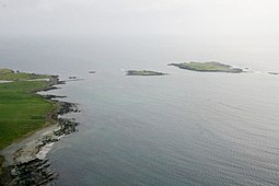
The West Voe of Sumburgh,, is the most southerly bay on the Shetland Mainland, located between Sumburgh Head, and the point of Scat Ness.

The Holm of Scockness is a small island in the Orkney Islands, between Rousay and Egilsay.
Lady's Holm is an island off southern Mainland in the Shetland Islands. It is not to be confused with the Maiden Stack, which is also known as "Frau Stack"
There are numerous islands containing the word holm, mainly in northern Europe. In many cases the name is derived from the Old Norse holmr, meaning "a small and rounded islet". These include:
Dylewo is a village in the administrative district of Gmina Sypniewo, within Maków County, Masovian Voivodeship, in east-central Poland.

The Ness of Burgi is a narrow peninsula that stretches to the south from the Scat Ness headland of Mainland, Shetland, a Scottish island. It is in the parish of Dunrossness.

The Zenith of Iron Age Shetland is a combination of three sites in Shetland that have applied to be on the United Kingdom "Tentative List" of possible nominations for the UNESCO World Heritage Programme list of sites of outstanding cultural or natural importance to the common heritage of humankind. The application was made by the Shetland Amenity Trust in 2010, and in 2011 the site became one of 11 successful UK applications to join the Tentative List, three of them from Scotland.

Holm of Grimbister is an inhabited tidal islet in the Orkney archipelago of Scotland. Located in the Bay of Firth near Finstown it is connected to Mainland Orkney by a causeway.
White Sands Launch Complex 36 (LC-36) is a site at White Sands Missile Range used for launches of the Black Brant IX and Black Brant 9CM1. It was also used from May 1964 and January 1966 to launch the Little Joe 2 rocket for the Apollo Program.
The Black River is a river located in North Queensland, Australia.
Bear Branch is a stream in Iron and Reynolds counties in the U.S. state of Missouri. It is a tributary of the Black River.