
The Arctic Archipelago, also known as the Canadian Arctic Archipelago, is an archipelago lying to the north of the Canadian continental mainland, excluding Greenland.
Foula, located in the Shetland archipelago of Scotland, is one of the United Kingdom’s most remote permanently inhabited islands. Owned since the turn of the 20th century by the Holbourn family, the island was the location for the film The Edge of the World. RMS Oceanic was wrecked on the nearby Shaalds of Foula.
The Mainland is the main island of Shetland, Scotland. The island contains Shetland's only burgh, Lerwick, and is the center of Shetland's ferry and air connections.

Baleshare is a flat tidal island in the Outer Hebrides of Scotland. Baleshare lies to the south-west of North Uist. Its economics and community were boosted by the building of a causeway in 1962. The 350 metres causeway was built by William Tawse Ltd. The island is extremely flat by Hebridean standards, rising to only 12 metres above sea level and known for its long sandy beach. It has a population of 49 living in two settlements: Samhla and Teananachar.

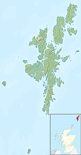
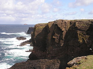
Bound Skerry is part of the Out Skerries group in the Shetland Islands. As well as being the most easterly island of that group, it is also the easternmost point of Scotland.

Garbh Eileach is an uninhabited island in the Inner Hebrides of the west coast of Scotland. It is the largest of the Garvellachs and lies in the Firth of Lorne between Mull and Argyll.
Eileach an Naoimh, also known as Holy Isle, is an uninhabited island in the Inner Hebrides of the west coast of Scotland. It is the southernmost of the Garvellachs archipelago and lies in the Firth of Lorne between Mull and Argyll. The name is Gaelic for "rocky place of the saint".

HMS Verulam was an Admiralty V-class destroyer of the Royal Navy. She was built by Hawthorn Leslie and was launched on 3 October 1917. She struck a mine off the island of Seiskari in the Gulf of Finland on the night between 3–4 September 1919, and sank killing 16 crew.

Casas de Benítez is a municipality in Cuenca, Castile-La Mancha, Spain. It has a population of 1,118.
Eilean Mhealasta is an uninhabited island off the west coast of Lewis in the Outer Hebrides of Scotland. It takes its name from Mealista, a nearby township on Lewis.
Garbh Eilean is one of the Shiant Islands at the south end of the Minch on the west coast of Scotland.

Espadañedo is a municipality located in the province of Zamora, Castile and León, Spain. According to the 2009 census (INE), the municipality has a population of 158 inhabitants.

Nesting is a parish in the Shetland Islands, Scotland. It includes a part of the east Shetland Mainland, measuring about twelve by four miles, along the seaboard from Gletness to Lunna Ness, and also the island of Whalsay and the Out Skerries. The coast is deeply indented by voes and headlands. The arable land comprises only about 1,000 acres, the remainder being mostly open moorland. The total area is given as 105.6 km2. This includes the ancient parish of Lunnasting in the North and the island parish of Whalsay to the east, which were added to Nesting in 1891. Before that, the ancient parishes of North Nesting and South Nesting were merged.

The Motagua Fault is a major, active left lateral-moving transform fault which cuts across Guatemala, continuing offshore along the southern Pacific coast of Mexico, returning onshore along the southernmost tip of Oaxaca, then continuing offshore until it merges with the Middle America Trench near Acapulco. It forms part of the tectonic boundary between the North American Plate and the Caribbean Plate. It is considered the onshore continuation of the Swan Islands Transform Fault which runs under the Caribbean Sea.
This is a list of the extreme points and extreme elevations in Scotland.

The borders of the oceans are the limits of Earth's oceanic waters. The definition and number of oceans can vary depending on the adopted criteria. The principal divisions of the five oceans are the Pacific Ocean, Atlantic Ocean, Indian Ocean, Southern (Antarctic) Ocean, and Arctic Ocean. Smaller regions of the oceans are called seas, gulfs, bays, straits, and other terms. Geologically, an ocean is an area of oceanic crust covered by water.
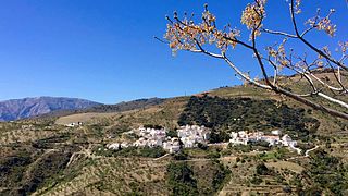
Polopos is a municipality in the province of Granada, Spain. As of 2010, it has a population of 1856 inhabitants.
German submarine U-532 was a Type IXC U-boat of Nazi Germany's Kriegsmarine during World War II.
This page is based on this
Wikipedia article Text is available under the
CC BY-SA 4.0 license; additional terms may apply.
Images, videos and audio are available under their respective licenses.