See also
60°9′57″N1°20′7″W / 60.16583°N 1.33528°W
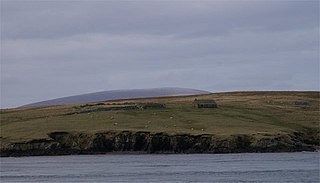
North Havra (Old Norse : Hafrey, ocean island) is a small island off south west Shetland. It is 30 metres at its highest point.
Situated 1/3 mile from the ness-end of South Whiteness, the island possess a lighthouse and a couple of small sheep pens (cribs), as well as a couple dozen sheep and different bird species. North Havra is currently owned by Thomas Stout who uses it for crofting.
60°9′57″N1°20′7″W / 60.16583°N 1.33528°W

Kasilof is a census-designated place (CDP) in Kenai Peninsula Borough, Alaska, United States. At the 2020 census the population was 525, down from 549 in 2010.

The Brough of Birsay is an uninhabited tidal island off the north-west coast of The Mainland of Orkney, Scotland, in the parish of Birsay. It is located around 13 miles north of Stromness and features the remains of Pictish and Norse settlements as well as a modern lighthouse.

Mousa is a small island in Shetland, Scotland, uninhabited since the nineteenth century. The island is known for the Broch of Mousa, an Iron Age round tower, and is designated as a Special Protection Area for storm-petrel breeding colonies.

East Burra is one of the Scalloway Islands, a subgroup of the Shetland Islands in Scotland. It is connected by a bridge to West Burra.
Sanda Island is a small island in the Firth of Clyde, off of Argyll and Bute, Scotland, near the southern tip of the Kintyre peninsula, near Southend and Dunaverty Castle.
Vaila is an island in Shetland, Scotland, lying south of the Westland peninsula of the Shetland Mainland. It has an area of 327 hectares, and is 95 metres (312 ft) at its highest point.

South Havra, formerly Hevera, is an uninhabited island in the Scalloway Islands, Shetland, Scotland.

Ronay is an island in the Outer Hebrides of Scotland, which lies a short distance off the east coast of Grimsay.

Isay is an uninhabited island in the Inner Hebrides of the west coast of Scotland. It lies in Loch Dunvegan, 1 kilometre (1,100 yd) off the northwest coast of the Isle of Skye. Two smaller isles of Mingay and Clett lie nearby. The name originated from the Old Norse ise-øy meaning porpoise island. The island of Lampay is due south. The area of Isay is 60 hectares.

Linga is a very small uninhabited island in the Bluemull Sound, Shetland, Scotland. It is one of many islands in Shetland called Linga. It has an area of 45 ha and is 26m at its highest point.
Pabay is a Scottish island just off the coast of Skye. The name Pabay is derived from an old Norse word meaning "priest's isle" and there are the remains of a 13th-century chapel.

Bigga is an uninhabited island in the Yell Sound between the Mainland and Yell in Shetland, Scotland.
Linga is a small, uninhabited island, 1 km (0.62 mi) east of Muckle Roe in the Shetland Islands. The island is roughly circular in shape and its highest elevation is 69 metres (226 ft). Its area is 70 hectares (0.27 sq mi).

The Scalloway Islands are in Shetland opposite Scalloway on south west of the Mainland. They form a mini-archipelago and include:
Island Macaskin or MacAskin is an island in Loch Craignish, in the Inner Hebrides of Scotland. It is owned by the Jenkin family and has been since 1904.
Fuaigh Mòr is an island in the Outer Hebrides of Scotland. It is off the west coast of Lewis near Great Bernera in Loch Ròg. It is 84 hectares and 67 metres at its highest point.

Weisdale is a bay, hamlet and ancient parish on Mainland in Shetland, Scotland. The bay opens near the northern extremity of Scalloway Bay, and strikes four and a half miles to the north north east.
Little Havra is a small island off the west of South Mainland in Shetland. It is 35 metres (115 ft) at its highest point, upon which there is a cairn. It is located west of South Havra.
The Shaw River is an ephemeral river in the Pilbara region of Western Australia. It was named by explorer F.T. Gregory on 21 August 1861 after Norton Shaw, Secretary of the Royal Geographical Society.
The Whitlock Valley is a small valley in southeast Graham County, Arizona, southwestern United States, lying between three mountain ranges. The valley lies on the south perimeter region of the White Mountains in eastern Arizona, and lies south of the west-flowing Gila River, and the region transitions south into Cochise County and three large valleys, with some scattered dry lakes. The valley is endorheic, with a small dry lake called Parks Lake, and merges southwest into the north of the San Simon Valley, where the San Simon River has its origins in the flatlands, and surrounding perimeter mountains. The valley was named after Captain James H. Whitlock who commanded during the Battle of Mount Gray in 1864 which was fought near the valley.