


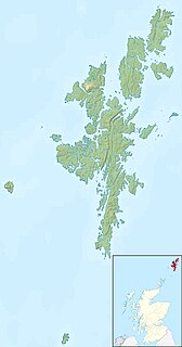
The North Isles are the northern islands of the Shetland Islands, Scotland. The main islands in the group are Yell, Unst and Fetlar. Sometimes the islands in Yell Sound are included in this group.
The North Isles are the northern islands of the Shetland Islands, Scotland. The main islands in the group are Yell, Unst and Fetlar. Sometimes the islands in Yell Sound are included in this group.
They are a significant group, since Yell and Unst are the second and third largest islands in the archipelago, and also the third and fourth most populous (Whalsay, which is not in the group, is the second most populous). Combined, their total land area is far larger than the rest of the Shetland Islands (excluding Mainland) combined.
The group also contains the most northerly land of the United Kingdom and Shetland at Out Stack near Muckle Flugga, and its most northerly settlement Skaw on Unst. These also happen to be the most northerly British territorial claims currently in existence, since Canadian independence. In similar fashion, Britain's most northerly maritime claims are also based on these islands, having great effect on its fishing and oil industries.
Fetlar also contains some of the most easterly points of Scotland with the exception of the Out Skerries, and much of Fetlar and Unst are under 350 km from Norway.
Travellers do not encounter any further land masses between Out Stack and the North Pole if heading directly north.
Other British records include -
The regular ferries are the most northerly scheduled routes in the British Isles (excluding those going to the Faroes and Iceland). They operate between Yell and Unst, Yell and Fetlar and Yell and Mainland.
Yell is one of the North Isles of Shetland, Scotland. In the 2011 census it had a usually resident population of 966. It is the second largest island in Shetland after the Mainland with an area of 82 square miles (212 km2), and is the third most populous in the archipelago, after the Mainland and Whalsay.
Fetlar is one of the North Isles of Shetland, Scotland, with a usually resident population of 61 at the time of the 2011 census. Its main settlement is Houbie on the south coast, home to the Fetlar Interpretive Centre. Fetlar is the fourth-largest island of Shetland and has an area of just over 4,000 hectares (15 sq mi).
Unst is one of the North Isles of the Shetland Islands, Scotland. It is the northernmost of the inhabited British Isles and is the third-largest island in Shetland after the Mainland and Yell. It has an area of 46 square miles (120 km2).

Out Stack or Ootsta is an island in Shetland, Scotland and the northernmost point of both the United Kingdom and the British Isles. It has been described as "the full stop at the end of Great Britain".

Muckle Flugga lighthouse punctuates the rocky stack of Muckle Flugga, in Shetland, Scotland. Originally called North Unst Lighthouse, it was renamed in 1964.

Muckle Flugga is a small rocky island north of Unst in the Shetland Islands, Scotland. It is often described as the northernmost point of the British Isles, but the smaller islet of Out Stack is actually farther north. It used to be the northernmost inhabited island, but forfeited that accolade to Unst when Muckle Flugga Lighthouse was automated in 1995 and the last residents moved out.
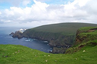
Hermaness is the northernmost headland of Unst, the most northerly inhabited island of Shetland, Scotland. It consists of huge sea cliffs and moorland, making it an ideal habitat for a variety of birds. Hermaness was designated a national nature reserve (NNR) in 1955. The NNR extends over 965 hectares, including the whole of the Hermaness peninsula and the outlying Muckle Flugga and Out Stack. The reserve has a path and boardwalk that extends out onto the moorland. The reserve is managed by NatureScot, though it remains in private ownership, with most being owned by the Buness Estate, although the stacks and skerries around Muckle Flugga are owned by the Northern Lighthouse Board.

Linga is a very small uninhabited island in the Bluemull Sound, Shetland, Scotland. It is one of many islands in Shetland called Linga. It has an area of 45 ha and is 26m at its highest point.

Haroldswick or Harold's Wick, is on Unst, Shetland Islands, Scotland, and is one of the most northerly settlements in the British Isles.

Baltasound is the largest settlement on the island of Unst in Shetland, Scotland. It comes from the Old Norse man's name Balti (Baltisund). Unst is the most northerly inhabited island in the United Kingdom. The village lies halfway along the island's east coast on a sheltered bay called Balta Sound.

The Valhalla Brewery in Unst, Shetland, Scotland, was the northernmost brewery in the United Kingdom. It was opened by the husband and wife team Sonny and Silvia Priest in December 1997, and originally based in a large shed in Baltasound, in the centre of Unst. In 2012 the brewery moved to a building at the former RAF Saxa Vord radar station, near Haroldswick. This larger premises allowed the brewery to double production to 144,000 litres a year.

Yell Sound is the strait running between Yell and Mainland, Shetland, Scotland. It is the boundary between the Mainland and the North Isles and it contains many small islands. Sullom Voe, on the shores of which is a substantial oil terminal, is an arm of Yell Sound.

The A968 in Shetland is the United Kingdom's northernmost A-road. It connects the islands of Yell and Unst to the island of Mainland. The road is actually separated into three. The length of the part of the road on Mainland is 9.8 miles (15.8 km), on Yell 17.4 miles (28.0 km), and on Unst it is 10 miles (16 km). The road is marked red on most maps and goes from the A970 on Mainland to Haroldswick. It is 41.9 miles (67.4 km) long.
Geopark Shetland is the name used by the Geopark formally established in September 2009 on its entry into the European Geoparks Network. The Geopark extends across the entire Shetland archipelago off the north coast of mainland Scotland. It is administered by the Shetland Amenity Trust in partnership with organisations such as Scottish Natural Heritage, the Shetland Islands Council, Highlands and Islands Enterprise and various community and tourism associations.
Shetland Islands Council Ferries is a company operating inter-island ferry services in Shetland, a subarctic archipelago off the northeast coast of Scotland.
Delting is a civil parish and community council area on Mainland, Shetland, Scotland. It includes the Sullom Voe oil terminal and its main settlements are Brae, Mossbank and Voe.
Muckle may refer to:
| Inhabited islands | ||
|---|---|---|
| Other islands | ||
| Towns and villages | ||
| Points of interest | ||
| Inhabited islands | ||
|---|---|---|
| Other islands | ||
| Towns and villages | ||
| Mainland Parishes | ||
| Insular Parishes | ||
| Maritime features | ||
Extreme points
| ||
| Topics | ||
Coordinates: 60°40′N1°0′W / 60.667°N 1.000°W
| | This Shetland location article is a stub. You can help Wikipedia by expanding it. |