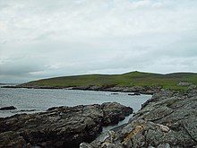
Looking SSW across the Bight of Cudda, West Linga, towards the Head of Berg.
Geography and geology
West Linga is a long narrow island covered in rough heath. It is separated from Whalsay by Linga Sound, and Lunning on Mainland, Shetland to the west. Little Linga, Swarta Skerry, Lona Skerry and Ketill Holm lie to the west. The Calf of Linga to the south is a drying islet. Wether Holm is separated by a 3 metres (10ft) deep channel at the north end.[4]
There are two lochs, and a natural arch in the north west. The two main hills are at either end - North and South Ward. There is a cairn in the south.[5]
West Linga appears to have been inhabited intermittently until the late 18th century. The lack of an anchorage and somewhat brackish water have hindered settlement.[4]
Some acreage on "Liungøuo í Hwalsøyo" is recorded in 1485 for sale for ten marks, as part of an illegal land sale, at Holy Cross Church near Bergen in Norway.[6]
Hugh MacDiarmid who lived on nearby Whalsay, said in The Uncanny Scot that he had spent three days on the island, living in a cave, with many matches and two books. In fact it transpired that he'd been there only for a few hours.[4] One of MacDiarmid's best known poems was On a Raised Beach.
The Mainland, also known as Hrossey and Pomona, is the main island of Orkney, Scotland. Both of Orkney's burghs, Kirkwall and Stromness, lie on the island, which is also the heart of Orkney's ferry and air connections.
Yell is one of the North Isles of Shetland, Scotland. In the 2011 census it had a usually resident population of 966. It is the second largest island in Shetland after the Mainland with an area of 82 square miles (212 km2), and is the third most populous in the archipelago, after the Mainland and Whalsay.
Whalsay is the sixth largest of the Shetland Islands in the north of Scotland.
The Out Skerries are an archipelago of islets, some inhabited, in Shetland, Scotland, and are the easternmost part of Shetland. Locally, they are usually called Da Skerries or just Skerries.
Hildasay, also known as Hildisay, is an uninhabited island off the west coast of the Shetland Mainland.
Housay, also known as West Isle, is one of the three islands that form the Out Skerries island group, the most easterly part of the Shetland Isles.
Bruray is one of the three Out Skerries islands of Shetland, and contains Scotland's most easterly settlement.
Linga is a small, uninhabited island, 1 km (0.62 mi) east of Muckle Roe in the Shetland Islands. The island is roughly circular in shape and its highest elevation is 69 metres (226 ft). Its area is 70 hectares (0.27 sq mi).
Yell Sound is the strait running between Yell and Mainland, Shetland, Scotland. It is the boundary between the Mainland and the North Isles and it contains many small islands. Sullom Voe, on the shores of which is a substantial oil terminal, is an arm of Yell Sound.
Linga is one of the Shetland Islands, near Vaila and Walls on Mainland, Shetland. Its highest elevation is 28 metres (91 ft). In 2014 and 2018 it was reported that the island was for sale for £250,000.
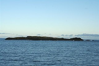
East Linga is one of the Shetland Islands. It lies between Whalsay, and Grif Skerry to the east.
Nesting is a parish in the Shetland Islands, Scotland. It includes a part of the east Shetland Mainland, measuring about twelve by four miles, along the seaboard from Gletness to Lunna Ness, and also the island of Whalsay and the Out Skerries. The coast is deeply indented by voes and headlands. The arable land comprises only about 1,000 acres, the remainder being mostly open moorland. The total area is given as 105.6 km2. This includes the ancient parish of Lunnasting in the North and the island parish of Whalsay to the east, which were added to Nesting in 1891. Before that, the ancient parishes of North Nesting and South Nesting were merged.
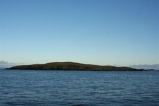
Little Linga is a small island in the Shetland Islands. It is near West Linga and Vidlin on Mainland, Shetland. It is 20 metres (66 ft) at its highest point. It measures 500 metres (550 yd) from north to south.
Shetland Islands Council Ferries is a company operating inter-island ferry services in Shetland, a subarctic archipelago off the northeast coast of Scotland. The company operates services across 10 of the Shetland islands.
Rumble is a skerry in the Shetland islands of Scotland, situated roughly 4 kilometres (2.5 mi) east off the coast of Huxter, southeastern Whalsay. It lies 0.75 miles (1.21 km) to southwest of East Linga. The main island, also known as Rumble Holm, is 27 feet (8.2 m) high. Nearby and to the north are the Flaeshans of Rumble, a series of small islets and stacks and Burlastack of Rumble lies to the east. On the northern side of the main island is an inlet, known as the Voe of Rumble. Lobsters and prawns are said to shelter here. It is also mentioned that a ship named Griften of unknown nationality was shipwrecked either here or on the Holm of Sandwick in 1611.
St Magnus Bay is a large coastal feature in the north-west of Mainland Shetland, Scotland. Roughly circular in shape with a diameter of about 19 kilometres (12 mi), it is open to the North Atlantic Ocean to the west. The indented coastline to the north, south and east between Esha Ness in the north and the Ness of Melby in the south contains numerous bays, firths and voes and there are several islands around the perimeter. The waters of the bay are up to 165 metres (541 ft) deep and may have been the site of a substantial meteor impact.
This page is based on this Wikipedia article Text is available under the CC BY-SA 4.0 license; additional terms may apply. Images, videos and audio are available under their respective licenses.