Symbister

Last updated

Symbister
Symbister Harbour, Whalsay - geograph.org.uk - 116092.jpg
Symbister Harbour, viewed from Ward of Clate
Shetland UK location map.svg
Red pog.svg
Symbister
Location within Shetland
Population797 
OS grid reference HU539622
Civil parish
Council area
Lieutenancy area
Country Scotland
Sovereign state United Kingdom
Post town SHETLAND
Postcode district ZE2
Dialling code 01806
Police Scotland
Fire Scottish
Ambulance Scottish
UK Parliament
Scottish Parliament
Symbister Ness Lighthouse OOjs UI icon edit-ltr-progressive.svg
Light on Symbister Ness (geograph 3346747).jpg
Coordinates 60°20′26″N1°02′17″W / 60.340482°N 1.038066°W / 60.340482; -1.038066
Constructed1904 (first)
Foundationconcrete basement
Constructionmetal skeletal tower (current)
cast iron tower (first)
Height7 metres (23 ft)
Shapequadrangular tower covered by aluminium panels with light on the top (current)
octagonal prism tower with balcony and lantern
Markingswhite tower
Power sourcesolar power  OOjs UI icon edit-ltr-progressive.svg
OperatorNorthern Lighthouse Board [1]
First lit2000s
Focal height11 metres (36 ft)
Rangewhite: 8 nautical miles (15 km; 9.2 mi)
green: 6 nautical miles (11 km; 6.9 mi) [2]
Characteristic Fl (2) WG 12s.
List of places
UK
Scotland
60°20′28″N1°01′19″W / 60.341°N 1.022°W / 60.341; -1.022

Symbister is the largest village and port on Whalsay, an island in the Shetland archipelago of Scotland. The population in 1991 was 797. The focus of the village is the harbour, which is home to small fishing boats as well as large deep sea trawlers. The village is overlooked by the granite mansion Symbister House, built by the Sixth Robert Bruce of Symbister in 1823. [3] The harbour is also known by the names Bay Of Symbister, Symbister Harbour and Symbister Old Harbour. [4]

Contents

The Pier House, now a museum, was once the centre for the export of dried and salted fish to the Hanseatic League, an alliance of trading guilds that established and maintained a trade monopoly over much of Northern Europe between the 13th and 17th centuries.

History

The island has been inhabited for more than 4000 years as witnessed by the Neolithic houses of Yoxie and Benie. An Iron Age block house to the northeast overlooks the Loch of Huxter. In the 14th century, the Huxters took over the island and held it until they went bankrupt in the 1830s. [5] Germans also sailed to Symbister for trading and brought their goods, iron tools, seeds, salt and cloth to barter for dried and salted fish from the island. [5] The old Hanseatic house which had been used by the Germans for several centuries until 1707, was refurbished into the museum. [5]

William Bruce of Symbister, who had migrated from Fife to Symbister, was a deputy to Laurence Bruce of Cultamalindie. In 1571, he was the Great Foude of Shetland, under Lord Robert Stewart. He married Marjorie Stewart, a daughter of John Stewart, Commendator of Coldingham. After his retirement, he moved back to his home country but he left his properties at Symbister to his eldest son and Fife to a son by his second wife. William Bruce, his grandson, the third in the lineage left his properties to a son by his second wife. The family lived in Symbister until recently and had considerable power on the island. [3] [6]

Tobset Bruce built the Symbister House at a cost of more than £30,000 using granite in 1823. In the 1850s, Robert Bruce of Symbister leased part of his estate to Robert Mouatvery, a merchant who illtreated his tenants and exploited the four estates.[ citation needed ] Symbister estate's fishing tenure under his lease was still run in a primitive form even in the 1860s, as William Stewart testified before a Royal Commission in 1872. [5]

Symbister House Symbister House, Whalsay - geograph.org.uk - 116089.jpg
Symbister House

The last resident of the Symbister House died in 1944. Since the 1960s, Symbister House has been used as Whalsay Junior High School, providing education to students of age 416. [3] The land around the Symbister House has an old wooden boat sculpture. Ghost stories are also narrated about this place, including that of an old sailor who was murdered for arguing with the gardener of the house during a game of cards. [7]

Facilities and economy

Symbister harbour and ferry terminal Symbister harbour and ferry terminal, Whalsay, Shetland - geograph.org.uk - 95477.jpg
Symbister harbour and ferry terminal

Symbister is a sheltered harbour and is busy with small fishing boats and recreational craft plying alongside large ocean-going trawlers. The marina here is a seventy-berth facility and also accommodates ferries travelling between the islands. A ferry to Laxo on the Shetland mainland operates from Symbister. Apart from ferry services, Symbister is also accessible by road from Whalsay airstrip, located in the island at its northeastern end at Skaw. [3]

As a village, Symbister has infrastructure facilities and basic amenities such as a post-office, many shops, a community hall, police station and a medical hospital with surgical facilities. [3] Whalsay Leisure Centre, Grieve House camping Böd and Harbison Park, home of Whalsay Football Club, are also of note. Symbister Harbour is now a modern harbour with a large fleet of fishing craft which have contributed to the economic progress of the island and making it one of the most prosperous in the region. [8] Whalsay Boating and Sports Club is based at the harbour.

Fishing has been the mainstay of the island of Whalsay and its harbour housed the fishing community. [5] During the earlier centuries herring was the main fishing focus with catches peaking in 1834. However, this industry suffered due to drastic decline of yield within a few years. Fishing picked up again in the late 1800s and in the mid-1900s. [9]

Aquatic fauna

Sea mammals such as porpoise, dolphin, minke whale, and orca can be seen from the rocks offshore over the harbour. Many migrants birds, like wheatear, meadow pipit, snow bunting and buff breasted sandpiper have been sighted. [5]

See also

Related Research Articles

Papa Stour is one of the Shetland Islands in Scotland, with a population of under fifteen people, some of whom immigrated after an appeal for residents in the 1970s. Located to the west of mainland Shetland and with an area of 828 hectares, Papa Stour is the eighth largest island in Shetland. Erosion of the soft volcanic rocks by the sea has created an extraordinary variety of caves, stacks, arches, blowholes, and cliffs. The island and its surrounding seas harbour diverse populations of wildlife. The west side of the island is a Site of Special Scientific Interest and the seas around the island are a Special Area of Conservation.

<span class="mw-page-title-main">Whalsay</span>

Whalsay is the sixth largest of the Shetland Islands in the north of Scotland.

<span class="mw-page-title-main">Scalloway</span> Human settlement in Shetland, Scotland

Scalloway is the largest settlement on the west coast of the Mainland, the largest island of the Shetland Islands, Scotland. The village had a population of roughly 900, at the 2011 census. Now a fishing port, until 1708 it was the capital of the Shetland Islands.

<span class="mw-page-title-main">Yell Sound</span>

Yell Sound is the strait running between Yell and Mainland, Shetland, Scotland. It is the boundary between the Mainland and the North Isles and it contains many small islands. Sullom Voe, on the shores of which is a substantial oil terminal, is an arm of Yell Sound.

<span class="mw-page-title-main">Laxo</span> Human settlement in Scotland

Laxo is a small settlement at the end of Laxo Voe in Vidlin, Shetland, Scotland.

Shetland Islands Council Ferries is a company operating inter-island ferry services in Shetland, a subarctic archipelago off the northeast coast of Scotland. The company operates services across 10 of the Shetland islands.

<span class="mw-page-title-main">Huxter</span> Human settlement in Scotland

Huxter is a crofting township in southeastern Whalsay in the parish of Nesting in the Shetland islands of Scotland. It lies to the east of Symbister, just north of the Loch of Huxter. Huxter Fort is located in the vicinity, reached by foot along a causeway.

<span class="mw-page-title-main">Symbister House</span> Historic site in Scotland

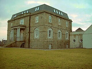
Symbister House is a former country house in Symbister, Whalsay island, in the Shetland islands of Scotland. It was built in 1823 by the Bruce family who were lairds (landlords) of the island for about 300 years from the 16th century. Since 1964 it has been the Whalsay Secondary School, after it fell into disuse following the death of the last of the landlord occupants of the house in 1944. Built in an elegant Georgian architectural style, it is categorized officially as a category B Listed Building and heritage structure.

<span class="mw-page-title-main">Hamister</span> Human settlement in Scotland

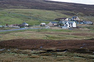
Hamister is a village in southwestern Whalsay in the parish of Nesting in the Shetland Islands of Scotland. It lies to the north of Symbister, just to the northeast of Saltness and southeast of North Park.

<span class="mw-page-title-main">Saltness</span> Human settlement in Scotland

Saltness is a hamlet in southwestern Whalsay in the parish of Nesting in the Shetland Islands of Scotland. It lies in the northern part of Symbister, just to the southwest of Hamister.

<span class="mw-page-title-main">North Park, Whalsay</span> Human settlement in Scotland

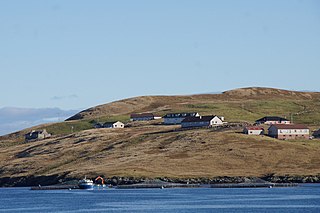
North Park is a hamlet in southwestern Whalsay in the parish of Nesting in the Shetland Islands of Scotland. It lies to the north of Saltness and Symbister, just to the northwest of Hamister.

<span class="mw-page-title-main">Loch of Huxter</span> Loch in Shetland Islands, Scotland

Loch of Huxter is a loch of southeastern Whalsay, Shetland Islands, Scotland, to the southwest of the village of Huxter. There is a water pumping station on its bank. Huxter Fort is located on an islet to the southeast of the loch, connected by a causeway.

<span class="mw-page-title-main">Treawick</span> Human settlement in Scotland

Treawick, also Traewick, is an uninhabited crofting village in eastern Whalsay in the parish of Nesting in the Shetland Islands of Scotland. It is located to the south of Isbister and northeast of Huxter. Falsa Burn flows into the sea just to the south. The name of the village is Old Norse for tree. In the 1930s, when the road from Symbister to Isbister was being planned, the villagers protested against it passing through the village so it passed to the west of the village. The old crofting houses here have long been abandoned. Offshore is Rumble.

<span class="mw-page-title-main">Huxter Fort</span> Iron Age fortification in Scotland

Huxter Fort is an Iron Age fortification on the island of Whalsay, in the Shetland islands of Scotland, dating to around 300 BC. It is on an islet in the Loch of Huxter, connected to the shore by a causeway.

<span class="mw-page-title-main">Skate of Marrister</span>

The Skate of Marrister is a flat ledge that extends about 300 yards (270 m) from the western shore of Whalsay, in the Shetland islands of Scotland. It is slightly more than 1 mile (1.6 km) north-north-west from Symbister Ness off the village of Marrister, in Linga Sound. At low tide the ledge rises 5 feet (1.5 m) above the water. There is a risk that the strong tide in Whalsay Sound will carry a boat onto the Skate. There is a minor light on the Skate with a nominal range of four miles, flashing green every six seconds.

<span class="mw-page-title-main">Setter Hill, Whalsay</span>

Setter Hill is a hill in western Whalsay, Shetland Islands, Scotland. It lies to the southeast of the village of Marrister and northeast of the main village on the island, Symbister. The source of Scarfmoor Burn is on the southeastern side of Setter Hill. On its eastern side is the Loch of Houll. There is an old quarry in the vicinity. Since the spring of 2001, the hill has been part of Shetland's Past Project, a project geared towards encouraging and training individuals to undertake archaeological surveys of their local landscapes in the Shetland Islands.

<span class="mw-page-title-main">Rumble, Shetland</span>

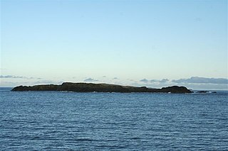
Rumble is a skerry in the Shetland islands of Scotland, situated roughly 4 kilometres (2.5 mi) east off the coast of Huxter, southeastern Whalsay. It lies 0.75 miles (1.21 km) to southwest of East Linga. The main island, also known as Rumble Holm, is 27 feet (8.2 m) high. Nearby and to the north are the Flaeshans of Rumble, a series of small islets and stacks and Burlastack of Rumble lies to the east. On the northern side of the main island is an inlet, known as the Voe of Rumble. Lobsters and prawns are said to shelter here. It is also mentioned that a ship named Griften of unknown nationality was shipwrecked either here or on the Holm of Sandwick in 1611.

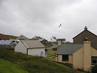
The Pier House Museum is a museum in Symbister, Whalsay, in the Shetland Islands of Scotland. The museum is located in the old Pier House, which was once the centre for trade with the Germans and the export of dried and salted fish to the Hanseatic League, an alliance of trading guilds that established and maintained a trade monopoly over much of Northern Europe between the 13th and 17th centuries. The Germans brought their goods, iron tools, seeds, salt and cloth to barter for dried and salted fish from the island. The old Hanseatic house which had been used by the Germans for several centuries until 1707, was refurbished for the museum, housing artefacts which date from the earlier trading period and providing an important insight into the economy of Shetland at the time. Architecturally it is described as "two-storeyed with crowstepped gables, and an external stone staircase." The house and port nearby are categorised officially as a category B Listed Building.

<span class="mw-page-title-main">Fethaland</span> Human settlement in Scotland

Fethaland or Fedeland is an abandoned settlement at the extreme north end of Mainland, Shetland. It was the site of the largest Haaf fishing station in Shetland.

<span class="mw-page-title-main">William Bruce of Symbister</span> Scottish landowner

William Bruce of Symbister and Sumburgh was a Scottish landowner.

References

  1. Rowlett, Russ. "Lighthouses of Scotland: Shetland". The Lighthouse Directory. University of North Carolina at Chapel Hill . Retrieved 31 May 2016.
  2. Symbister Ness Light Lighthouse Explorer. Retrieved 31 May 2016
  3. 1 2 3 4 5 "Symbister". Gazetteer for Scotland. Retrieved 1 February 2013.
  4. "Whalsay, Symbister, Pier House (Museum)". Official website of Royal Commission on the Ancient and Historical Monuments of Scotland. Retrieved 1 February 2013.
  5. 1 2 3 4 5 6 Holland, Julian (1 January 2009). Exploring the Islands of Scotland: The Ultimate Practical Guide. frances lincoln ltd. pp. 49–. ISBN   978-0-7112-2758-3 . Retrieved 3 January 2013.
  6. Goudie, Gilbert (May 2009). The Diary of the Rev. John Mill: Minister of the Parishes of Dunrossness Sandwick and Cunningsburgh in Shetland 1740-1803 with Selections from Local Records and Original Documents Relating to the District. Heritage Books. pp. 93–. ISBN   978-0-7884-2335-2 . Retrieved 3 January 2013.
  7. Marwick, Ernest W. (1975). The Folklore of Orkney and Shetland. Rowman & Littlefield Publishers, Incorporated. p. 96. ISBN   978-0-87471-681-8 . Retrieved 21 February 2013.
  8. Lonely Planet Scotland's Highlands & Islands. Lonely Planet. March 2012. pp. 344–. ISBN   978-1-74220-688-2 . Retrieved 3 January 2013.
  9. Thompson, Paul Richard; Wailey, Tony; Lummis, Trevor (1983). Living the Fishing. History Workshop Series. Routledge. p. 330. ISBN   9780710095084.