Yell is one of the North Isles of Shetland, Scotland. In the 2011 census it had a usually resident population of 966. It is the second largest island in Shetland after the Mainland with an area of 82 square miles (212 km2), and is the third most populous in the archipelago, after the Mainland and Whalsay.
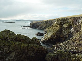
Papa Stour is one of the Shetland Islands in Scotland, with a population of under fifteen people, some of whom immigrated after an appeal for residents in the 1970s. Located to the west of mainland Shetland and with an area of 828 hectares, Papa Stour is the eighth largest island in Shetland. Erosion of the soft volcanic rocks by the sea has created an extraordinary variety of caves, stacks, arches, blowholes, and cliffs. The island and its surrounding seas harbour diverse populations of wildlife. The west side of the island is a Site of Special Scientific Interest and the seas around the island are a Special Area of Conservation.

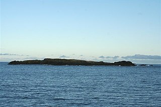
Hildasay, also known as Hildisay, is an uninhabited island off the west coast of the Shetland Mainland.
Housay, also known as West Isle, is one of the three islands that form the Out Skerries island group, the most easterly part of the Shetland Isles.

Esha Ness, also spelled Eshaness, is a peninsula on the west coast of Northmavine, on the island of Mainland, Shetland, Scotland. Esha Ness Lighthouse on the west coast, just south of Calder's Geo. It was designed by David Alan Stevenson and commissioned in 1929. The hamlet of Tangwick contains the Tangwick Haa Museum, which opened in the former Laird's house in 1987.
Muckle Holm is the name of a number of islands in Orkney and Shetland. It is an oxymoron, since muckle means "big" and "holm" refers to an islet.

Yell Sound is the strait running between Yell and Mainland, Shetland, Scotland. It is the boundary between the Mainland and the North Isles and it contains many small islands. Sullom Voe, on the shores of which is a substantial oil terminal, is an arm of Yell Sound.

Linga is one of the Shetland Islands, in Yell Sound.
There are numerous islands containing the word holm, mainly in northern Europe. In many cases the name is derived from the Old Norse holmr, meaning "a small and rounded islet". These include:
Clate is a hamlet and ward in southwestern Whalsay in the parish of Nesting in the Shetland Islands of Scotland.
Rumble is a skerry in the Shetland islands of Scotland, situated roughly 4 kilometres (2.5 mi) east off the coast of Huxter, southeastern Whalsay. It lies 0.75 miles (1.21 km) to southwest of East Linga. The main island, also known as Rumble Holm, is 27 feet (8.2 m) high. Nearby and to the north are the Flaeshans of Rumble, a series of small islets and stacks and Burlastack of Rumble lies to the east. On the northern side of the main island is an inlet, known as the Voe of Rumble. Lobsters and prawns are said to shelter here. It is also mentioned that a ship named Griften of unknown nationality was shipwrecked either here or on the Holm of Sandwick in 1611.
The Holm of Sandwick is an islet, located roughly 100 metres (330 ft) off Haa Ness and the southwestern side of Whalsay, in the Shetland Islands of Scotland. The small groups of islets to the west are called the Flaeshans of Sandwick. To the southwest is Sava Skerry. It is reported that a ship named Griften of unknown nationality was shipwrecked either here or on Rumble Holm in 1611.

St Magnus Bay is a large coastal feature in the north-west of Mainland Shetland, Scotland. Roughly circular in shape with a diameter of about 19 kilometres (12 mi), it is open to the North Atlantic Ocean to the west. The indented coastline to the north, south and east between Esha Ness in the north and the Ness of Melby in the south contains numerous bays, firths and voes and there are several islands around the perimeter. The waters of the bay are up to 165 metres (541 ft) deep and may have been the site of a substantial meteor impact.
This page is based on this
Wikipedia article Text is available under the
CC BY-SA 4.0 license; additional terms may apply.
Images, videos and audio are available under their respective licenses.