A chambered cairn is a burial monument, usually constructed during the Neolithic, consisting of a sizeable chamber around and over which a cairn of stones was constructed. Some chambered cairns are also passage-graves. They are found throughout Britain and Ireland, with the largest number in Scotland.

A gallery grave is a form of megalithic tomb built primarily during the Neolithic Age in Europe in which the main gallery of the tomb is entered without first passing through an antechamber or hallway. There are at least four major types of gallery grave, and they may be covered with an earthen mound or rock mound.

Kilmartin Glen is an area in Argyll not far from Kintyre. It has the most important concentration of Neolithic and Bronze Age remains in mainland Scotland.

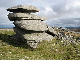
The Dwarfie Stane is a megalithic chambered tomb carved out of a titanic block of Devonian Old Red Sandstone located in a steep-sided glaciated valley between the settlements of Quoys and Rackwick on Hoy, an island in Orkney, Scotland. The stone is a glacial erratic located in desolate peatland.

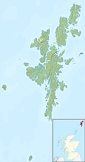
Heart of Neolithic Orkney refers to a group of Neolithic monuments found on the Mainland, one of the islands of Orkney, Scotland. The name was adopted by UNESCO when it proclaimed these sites as a World Heritage Site in 1999.

Gaerllwyd is a village in Monmouthshire, south east Wales, United Kingdom.

Midhowe Chambered Cairn is a large Neolithic chambered cairn located on the south shore of the island of Rousay, Orkney, Scotland. The name "Midhowe" comes from the Iron Age broch known as Midhowe Broch, that lies just west of the tomb. The broch got its name from the fact that it's the middle of three such structures that lie grouped within 500 metres (1,600 ft) of each other and Howe from the Old Norse word haugr meaning mound or barrow. Together, the broch and chambered cairn form part of a large complex of ancient structures on the shore of Eynhallow Sound separating Rousay from Mainland, Orkney.

Unstan is a Neolithic chambered cairn located about 2 miles (3 km) north-east of Stromness on Mainland, Orkney, Scotland. The tomb was built on a promontory that extends into the Loch of Stenness near the settlement of Howe. Unstan is notable as an atypical hybrid of the two main types of chambered cairn found on Orkney, and as the location of the first discovery of a type of pottery that now bears the name of the tomb. The site is in the care of Historic Environment Scotland as a scheduled monument.
Showery Tor is a rocky outcrop on a ridge-top approximately 0.6 kilometres (0.37 mi) north of the Rough Tor summit, near Camelford on Bodmin Moor in Cornwall. It is notable for its rock formations and prehistoric monuments.

Benie Hoose, also Bunyie Hoose, is a Neolithic site in the parish of Nesting, northeastern Whalsay, in the Shetland Islands of Scotland. It is located approximately 100 yards (91 m) to the northwest of the Standing Stones of Yoxie, and about 140 metres (460 ft) southeast of the Pettigarths Field Cairns. Benie Hoose and Yoxie demonstrate characteristics of 'paired houses'. It was excavated in 1954–1955 by Charles S. T. Calder who gave the items to the National Museum of Antiquities of Scotland in 1955–1956. Furthermore, its close proximity to Yoxie indicates that Druid priests probably lived in the house and performed ceremonies at the stones. OS (NKB) visited the site on 30 May 1968. The one-room site measures 24.4 by 12.8 metres, and features a horned forecourt.

The Standing Stones of Yoxie is a Neolithic site in the parish of Nesting on the northeastern coast of Whalsay, in the Shetland islands of Scotland. It is located approximately 100 yards (91 m) to the southeast of Benie Hoose, not far from the steep cliffs of Yoxie Geo. The site is also known as "Yoxie Biggins". The structure is the remains of a building in a neolithic settlement called Pettigarths Field, about 4,000 years old, which also includes a megalithic tomb and Benie Hoose. The site has been compared to that of Hal Tarxien.

Loch of Houll is a loch on Whalsay, one of the Shetland islands of Scotland. It is located to the southeast of Brough and on the eastern side of Setter Hill. An eastern tributary of the Scarfmoor Burn passes into the western side of the loch. It is described as a "large shallow loch with brown trout averaging 8-10 oz and some over 2 lbs." On the western side of the loch is Peerie Roonie House, a ruined stone house, which still has traces of the inner face of a drystone wall and drain. Archaeologists excavating at the site discovered stone tools dated to the Neolithic period and peat ash.

Stanydale Temple is a Neolithic site on Mainland, Shetland. It is located in a field to the south of the modern village of Stanydale, roughly 21 miles (34 km) by road northwest of Lerwick, to the northeast of the village of Gruting. Once a roofed building, all that remains is a large, walled enclosure. There is uncertainty about the original purpose of the building, but its unusual size indicates some communal purpose, or that it was possibly the home of an important person.

Charles S. T. Calder was a Scottish archaeologist who undertook extensive explorations from the 1920s to 1950s. He is best known for his explorations of Neolithic cairns and buildings in Shetland in the 1940s and 1950s, although his contribution to the investigative work and publications of RCAHMS during a period of over 40 years service cannot be overstated.

The Grey Cairns of Camster are two large Neolithic chambered cairns located about 8.5 miles (13.7 km) south of Watten and 5 miles (8.0 km) north of Lybster in Caithness, in the Highland region of Scotland. They are among the oldest structures in Scotland, dating to about 5,000 years ago. The cairns demonstrate the complexity of Neolithic architecture, with central burial chambers accessed through narrow passages from the outside. They were excavated and restored by Historic Scotland in the late 20th century and are open to the public.
British megalith architecture is the study of those ancient cultures that built megalithic sites on the British Isles, including the research and documentation of these sites. The classification sometimes used of these cultures based on geological criteria is problematic.

Tulach an t'Sionnaich, is a cairn at the northern end of Loch Calder in Caithness, Scotland that has been expanded over time. It was partially excavated in 1961 and 1963. Before the excavations there was just a 60-metre (200 ft) long and 12-metre (40 ft) wide cairn with no recognizable structures. The cairn is oriented from northwest to southeast; the southeastern end being higher and somewhat wider. Subsequently a ditch was cut some 15 metres (50 ft) from this end of the cairn.
Punds Water is a Neolithic heel-shaped cairn near Mangaster on Mainland, Shetland in the Shetland islands of Scotland. It is composed of large boulders and stands about 1.5 metres high above the surrounding peat. The facade faces east by southeast and measures more than 15 metres across. From front to back the cairn measures 9.8 metres. Within the facade is the entrance to a passage leading to a trefoil-shaped burial chamber.