Broch of West Burrafirth

Last updated

Coordinates: 60°17′53″N1°32′18″W / 60.298185°N 1.538235°W / 60.298185; -1.538235

Geographic coordinate system Coordinate system

A geographic coordinate system is a coordinate system that enables every location on Earth to be specified by a set of numbers, letters or symbols. The coordinates are often chosen such that one of the numbers represents a vertical position and two or three of the numbers represent a horizontal position; alternatively, a geographic position may be expressed in a combined three-dimensional Cartesian vector. A common choice of coordinates is latitude, longitude and elevation. To specify a location on a plane requires a map projection.

Contents

Broch of West Burrafirth
Broch of West Burrafirth - geograph.org.uk - 438680.jpg
Remains of the broch on the little holm
Shetland UK location map.svg
Archaeological site icon (red).svg
Shown within Shetland
Location Mainland, Shetland
Coordinates 60°17′53″N1°32′18″W / 60.298185°N 1.538235°W / 60.298185; -1.538235
Type Broch
History
Periods Iron Age

The Broch of West Burrafirth is an Iron Age broch located on the west side of Mainland, Shetland (grid reference HU25625720 ).

The British Iron Age is a conventional name used in the archaeology of Great Britain, referring to the prehistoric and protohistoric phases of the Iron Age culture of the main island and the smaller islands, typically excluding prehistoric Ireland, which had an independent Iron Age culture of its own. The parallel phase of Irish archaeology is termed the Irish Iron Age. The Iron Age is not an archaeological horizon of common artefacts, but is rather a locally diverse cultural phase.

Broch type of Iron Age drystone hollow-walled structure

A broch is an Iron Age drystone hollow-walled structure found in Scotland. Brochs belong to the classification "complex atlantic roundhouse" devised by Scottish archaeologists in the 1980s. Their origin is a matter of some controversy.

Mainland, Shetland the main island of Shetland, Scotland

The Mainland is the main island of Shetland, Scotland. The island contains Shetland's only burgh, Lerwick, and is the centre of Shetland's ferry and air connections.

Location

The broch stands on a low rocky islet (the "Holm of Hebrista") in West Burra Firth. [1] The site is inaccessible without a boat except at very low tide. [1] There was once a causeway from the islet to the shore, which is no longer readily apparent. [1]

Description

The broch is in a ruined state with much fallen debris. [1] The entrance is blocked with stones but the lintel over the inner end is still apparent. [1] There appear to be two guard cells on either side of the entrance passage. [1] Internally four mural cells can be seen, two of which are dumb-bell shaped with short passages between the two halves. [1] The site is a scheduled monument. [2]

Scheduled monument nationally important archaeological site or historic building in the United Kingdom

In the United Kingdom, a scheduled monument is a "nationally important" archaeological site or historic building, given protection against unauthorised change.

Later history

The Orkneyinga saga states of Magnus Erlendsson and Hákon Paulsson:

<i>Orkneyinga saga</i>

The Orkneyinga saga is a historical narrative of the history of the Orkney and Shetland islands and their relationship with other local polities, particularly Norway and Scotland. The saga has "no parallel in the social and literary record of Scotland" and is "the only medieval chronicle to have Orkney as the central place of action". The main focus of the work is the line of jarls who ruled the Earldom of Orkney, which constituted the Norðreyjar or Northern Isles of both Orkney and Shetland and there are frequent references to both archipelagoes throughout.

Magnus Erlendsson, Earl of Orkney Earl of Orkney

Saint Magnus Erlendsson, Earl of Orkney, sometimes known as Magnus the Martyr, was Earl of Orkney from 1106 to about 1115.

"Magnus and Hákon ruled their lands and defended them for some time, the two agreeing very well... They also slew a famous man, named Þorbjörn in Borgarfjörð in Hjaltland." [3]

Borgarfjörð, the "fjord of the borg" was so named by the Norse on account of the broch. [3] It is probable that the reason of Þorbjörn's connection with Borgarfjörð/Burra Firth was its affording him, and his followers a shelter, and a defensive position in the borg, or broch. [3] The old name Borgarfjörð occurs in a document in the Norse language dated 1299. [3]

Fjord A long, narrow inlet with steep sides or cliffs, created by glacial activity

Geologically, a fjord or fiord is a long, narrow inlet with steep sides or cliffs, created by a glacier. There are many fjords on the coasts of Alaska, Antarctica, British Columbia, Chile, Greenland, the Faroe Islands, Iceland, Kamchatka, the Kerguelen Islands, New Zealand, Norway, Novaya Zemlya, Labrador, Nunavut, Newfoundland, Quebec, Scotland, South Georgia Island, and Washington state. Norway's coastline is estimated at 29,000 kilometres (18,000 mi) with nearly 1,200 fjords, but only 2,500 kilometres (1,600 mi) when fjords are excluded.

Vikings Norse explorers, warriors, merchants, and pirates

Vikings were Norse seafarers, mainly speaking the Old Norse language, who during the late 8th to late 11th centuries, raided and traded from their Northern European homelands across wide areas of Europe, and explored westwards to Iceland, Greenland, and Vinland. The term is also commonly extended in modern English and other vernaculars to the inhabitants of Norse home communities during what has become known as the Viking Age. This period of Nordic military, mercantile and demographic expansion constitutes an important element in the early medieval history of Scandinavia, Estonia, the British Isles, France, Kievan Rus' and Sicily.

The broch was visited by George Low in the 18th century, when he noted a number of cells in the base of the wall, and he stated that a hollow, galleried wall began above these. [1]

Related Research Articles

Mousa small island in Shetland, Scotland

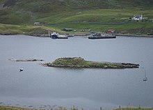
Mousa is a small island in Shetland, Scotland, uninhabited since the nineteenth century. The island is known for the Broch of Mousa, an Iron Age round tower, and is designated as a Special Protection Area for storm-petrel breeding colonies.

West Burra one of the Scalloway Islands, a subgroup of the Shetland Islands in Scotland.

West Burra is one of the Scalloway Islands, a subgroup of the Shetland Islands in Scotland. It is connected by bridge to East Burra. With an area of 743 hectares (2.87 sq mi), it is the eleventh largest of the Shetland Islands.

East Burra one of the Scalloway Islands, a subgroup of the Shetland Islands in Scotland

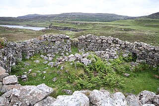
East Burra is one of the Scalloway Islands, a subgroup of the Shetland Islands in Scotland. It is connected by a bridge to West Burra.

Birsay human settlement in the United Kingdom

Birsay is a parish in the north west corner of The Mainland of Orkney, Scotland. Almost all the land in the parish is devoted to agriculture: chiefly grassland used to rear beef cattle. There are various ancient monuments in the parish.

Broch of Mousa finest preserved example of an Iron Age broch or round tower

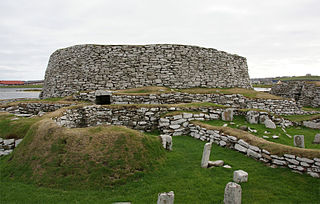
Broch of Mousa is the finest preserved example of an Iron Age broch or round tower. It is in the small island of Mousa in Shetland, Scotland. It is the tallest broch still standing and amongst the best-preserved prehistoric buildings in Europe. It is thought to have been constructed c. 100 BC, one of more than 500 brochs built in Scotland. The site is managed by Historic Environment Scotland as a scheduled monument.

Broch of Clickimin tower

The Broch of Clickimin is a large, well-preserved but restored broch in Lerwick in Shetland, Scotland. Originally built on an island in Clickimin Loch, it was approached by a stone causeway. The broch is situated within a walled enclosure and, unusually for brochs, features a large "forework" or "blockhouse" between the opening in the enclosure and the broch itself. The site is maintained by Historic Scotland. According to its excavator, John R.C. Hamilton, there were several periods of occupation of the site: Late Bronze Age farmstead, Early Iron Age farmstead, Iron Age fort, broch period, and wheelhouse settlement.

Broch of Culswick

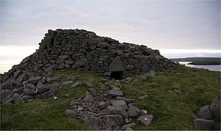
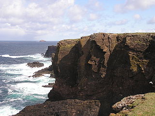
The Broch of Culswick is an unexcavated coastal broch in the Shetland Islands of Scotland. It has good views all around, including Foula and Vaila isles, and Fitful Head and Fair Isle in the south. The broch stands on the top of a rock platform and is about 3 metres high at its tallest point. Much rubble has fallen into the centre. This broch has a massive triangular lintel stone over the entrance, which is partly filled with rubble. Drawings by Low in 1774 and Skene in 1805 reveal that the structure survived very well up to those dates.

Haakon Paulsson was a Norwegian Jarl (1105–1123) and jointly ruled the Earldom of Orkney with his cousin Magnus Erlendsson. Their lives and times are recounted in the Orkneyinga Saga, which was first written down in the early 13th century by an unknown Icelandic author.

Burra, Shetland

Burra is the collective name for two of the Shetland Islands, West and East Burra, which are connected by bridge to one another, and to the Shetland Mainland via Trondra. They form part of the Scalloway Islands

Burroughston Broch

Burroughston Broch is an Iron Age broch located on the island of Shapinsay in the Orkney Islands, in Scotland. The site overlooks the North Sea on the northeast part of Shapinsay. Excavated in the mid 19th century, Burroughston Broch is still well-preserved. The drystone walls are up to four metres thick in some parts and there is a complete chamber intact off the entrance passage. Some remains of stone fittings are evident in the interior.

St Magnus Bay

St Magnus Bay is a large coastal feature in the north-west of Mainland Shetland, Scotland. Roughly circular in shape with a diameter of about 19 kilometres (12 mi), it is open to the North Atlantic Ocean to the west. The indented coastline to the north, south and east between Esha Ness in the north and the Ness of Melby in the south contains numerous bays, firths and voes and there are several islands around the perimeter. The waters of the bay are up to 165 metres (541 ft) deep and may have been the site of a substantial meteor impact.

Dun Telve An iron-age broch located about 4 kilometres southeast of the village of Glenelg, in Scotland, UK.

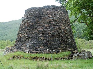
Dun Telve is an iron-age broch located about 4 kilometres (2.5 mi) southeast of the village of Glenelg, Highland, in Scotland. It is one of the best preserved brochs in Scotland.

Tirefour Castle

Tirefour Castle, is an Iron Age broch located 4 kilometres north of Achnacroish on the island of Lismore, Scotland.

Burra Ness Broch

Burra Ness Broch is an iron-age broch located on the east coast of the island of Yell, Shetland, Scotland.

Dun Fiadhairt archaeological site on Isle of Skye, Scotland

Dun Fiadhairt is an Iron Age broch located on the north coast of the island of Skye, in Scotland.

Dun Hallin

Dun Hallin is an Iron Age broch located near the northwest coast of the island of Skye, in Scotland.

Caisteal Grugaig

Caisteal Grugaig is an Iron Age broch near the eastern end of Loch Alsh in the Scottish Highlands.

Dun Bharabhat, Great Bernera tower

Dun Bharabhat is an Iron Age galleried dun or "semi-broch" situated on the island of Great Bernera near Lewis in Scotland.

Orphir Round Church church in United Kingdom

The remains of the Orphir Round Church, dedicated to Saint Nicholas, are located in Orphir Parish on the Mainland of Orkney, Scotland. It is thought to have been built by jarl (earl) Haakon Paulsson as penance for murdering his cousin and co-ruler Magnus Erlendsson in the late 11th or early 12th century. According to the Orkneyinga saga, earl Haakon took sole power in 1117 after the killing of Magnus, and the round kirk was later rededicated to St Magnus. The saga refers to a "large drinking-hall" with a "magnificent church" nearby. The remains of the drinking hall, known as the Earl's Bu, can still be seen, as well as a later Norse horizontal watermill.

References

  1. 1 2 3 4 5 6 7 8 Historic Environment Scotland. "West Burra Firth (371)". Canmore . Retrieved 15 September 2014.
  2. Historic Environment Scotland. "West Burra Firth,broch (SM2090)" . Retrieved 13 March 2019.
  3. 1 2 3 4 Joseph Anderson, (1873), The Orkneyinga saga. Translated by Jón A. Hjaltalin & Gilbert Goudie. Chapter 35 (page 60)