Broch of Gurness

Last updated

Broch of Gurness
Broch of Gurness2.jpg
Broch of Gurness
Orkney Islands UK location map.svg
Archaeological site icon (red).svg
Shown within Orkney Islands
Location Mainland, Orkney
RegionScotland
Coordinates 59°07′19″N3°04′41″W / 59.122°N 3.078°W / 59.122; -3.078
TypeIron age settlement
History
Periods Iron Age
Site notes
OwnershipHistoric Scotland
Public accessYes
Official nameAiker Ness,Broch of Gurness,broch and settlement
Designated4 May 1994
Reference no. SM90157

The Broch of Gurness is an Iron Age broch village on the northeast coast of Mainland Orkney in Scotland overlooking Eynhallow Sound, about 15 miles north-west of Kirkwall. It once housed a substantial community.

Contents

Description

Settlement here began sometime between 500 and 200 BC. [1] At the centre of the settlement is a stone tower or broch, which once probably reached a height of around 10 metres. Its interior is divided into sections by upright slabs. The tower features two skins of drystone walls, with stone-floored galleries in between. These are accessed by steps. Stone ledges suggest that there was once an upper storey with a timber floor. The roof would have been thatched, surrounded by a wall walk linked by stairs to the ground floor. The broch features two hearths and a subterranean stone cistern with steps leading down into it (resembling the set-up at Mine Howe). It is thought to have some religious significance, relating to an Iron Age cult of the underground. [1] [2] :38

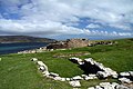
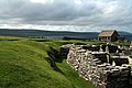
The remains of the central tower are up to 3.6 metres (11.8 ft) high, and the stone walls are up to 4.1 metres (13.5 ft) thick.

The roof probably was conical or mildly hyperbolic. [3]

The tower was likely inhabited by the principal family or clan of the area but also served as a last resort for the village in case of an attack. [1]

The broch continued to be inhabited while it began to collapse and the original structures were altered. The cistern was filled in and the interior was repartitioned. The ruin visible today reflects this secondary phase of the broch's use. [1]

The site is surrounded by three ditches cut out of the rock with stone ramparts, encircling an area of around 45 metres diameter. The remains of numerous small stone dwellings with small yards and sheds can be found between the inner ditch and the tower. These were built after the tower, but were a part of the settlement's initial conception. A "main street" connects the outer entrance to the broch. [2] :38 The settlement is the best-preserved of all broch villages. [1]

Pieces of a Roman amphora dating to before 60 AD were found here, lending weight to the record that a "King of Orkney" submitted to Emperor Claudius at Colchester in 43 AD. [4]

At some point after 100 AD the broch was abandoned and the ditches filled in. [1] It is thought that settlement at the broch continued into the 5th century AD, the period known as Pictish times. By that time the broch was not used anymore and some of its stones were reused to build smaller dwellings on top of the earlier buildings. [2] :38 Until about the 8th century, the site was just a single farmstead. [1]

In the 9th century, a Norse woman was buried at the site in a stone-lined grave with two bronze brooches and a sickle and knife made from iron. [2] :38 Other finds suggest that Norse men were buried here too. [1]

The broch is in the care of Historic Environment Scotland. [1]

[[]]

See also

Related Research Articles

<span class="mw-page-title-main">Broch</span> Type of Iron Age drystone hollow-walled structure

A broch is an Iron Age drystone hollow-walled structure found in Scotland. Brochs belong to the classification "complex Atlantic roundhouse" devised by Scottish archaeologists in the 1980s.

<span class="mw-page-title-main">Brough of Birsay</span> An uninhabited tidal island off the north-west coast of The Mainland of Orkney, Scotland

The Brough of Birsay is an uninhabited tidal island off the north-west coast of The Mainland of Orkney, Scotland, in the parish of Birsay. It is located around 13 miles north of Stromness and features the remains of Pictish and Norse settlements as well as a modern light house.

<span class="mw-page-title-main">Wyre, Orkney</span>

Wyre is one of the Orkney Islands, lying south-east of Rousay. It is 311 hectares (1.20 sq mi) and 32 metres (105 ft) at its highest point. It is one of the smallest inhabited islands in the archipelago.

<span class="mw-page-title-main">Papa Westray</span>

Papa Westray, also known as Papay, is one of the Orkney Islands in Scotland, United Kingdom. The fertile soil has long been a draw to the island.

<span class="mw-page-title-main">Jarlshof</span> Archeological site in Shetland, Scotland

Jarlshof is the best-known prehistoric archaeological site in Shetland, Scotland. It lies in Sumburgh, Mainland, Shetland and has been described as "one of the most remarkable archaeological sites ever excavated in the British Isles". It contains remains dating from 2500 BC up to the 17th century AD.

<span class="mw-page-title-main">Birsay</span>

Birsay is a parish in the north west corner of The Mainland of Orkney, Scotland. Almost all the land in the parish is devoted to agriculture: chiefly grassland used to rear beef cattle. There are various ancient monuments in the parish.

<span class="mw-page-title-main">Broch of Mousa</span> Tallest preserved example of an Iron Age broch or round tower

Broch of Mousa is a preserved Iron Age broch or round tower. It is on the island of Mousa in Shetland, Scotland. It is the tallest broch still standing and amongst the best-preserved prehistoric buildings in Europe. It is thought to have been constructed c. 100 BC, and is one of more than 500 brochs built in Scotland. The site is managed by Historic Environment Scotland as a scheduled monument.

<span class="mw-page-title-main">Dun Carloway</span>

Humans have inhabited Orkney, an archipelago in the north of Scotland, for about 8,800 years: Archeological evidence dates from Mesolithic times. Scandinavian clans dominated the area from the 8th century CE, using the islands as a base for further incursions. In the late 14th century the archipelago became part of Scotland.

<span class="mw-page-title-main">Old Scatness</span>

Old Scatness is an archeological site on Scat Ness, near the village of Scatness, in the parish of Dunrossness in the south end of Mainland, Shetland, Scotland, near Sumburgh Airport. It consists of medieval, Viking, Pictish, and Iron Age remains and has been a settlement for thousands of years, each new generation adding buildings, and levelling off old ones. Among the discoveries is an Iron Age broch, the Ness of Burgi fort.

Mine Howe is an Iron Age subterranean man-made chamber dug 6 meters deep inside a large mound. It is located in the Tankerness area of Orkney, Scotland, about 5 miles (8 km) southeast of Kirkwall, the capital of Orkney. The origin of the howe is not perfectly understood. Experts believe that it was built roughly 2000 years ago during the Iron Age. There is some similarity to the well inside the Iron Age Broch of Gurness.

<span class="mw-page-title-main">Burroughston Broch</span>

<span class="mw-page-title-main">Wheelhouse (archaeology)</span>

In archaeology, a wheelhouse is a prehistoric structure from the Iron Age found in Scotland. The term was first coined after the discovery of a ruined mound in 1855. The distinctive architectural form related to the complex roundhouses constitute the main settlement type in the Western Isles in the closing centuries BC. A total of 62 sites have now been identified in the Northern and Western Isles, and on the north coast of Caithness and Sutherland.

<span class="mw-page-title-main">Prehistoric Orkney</span> Overview of the prehistoric period on the Orkney Islands, Scotland

Prehistoric Orkney refers only to the prehistory of the Orkney archipelago of Scotland that begins with human occupation. Although some records referring to Orkney survive that were written during the Roman invasions of Scotland, “prehistory” in northern Scotland is defined as lasting until the start of Scotland's Early Historic Period.

<span class="mw-page-title-main">Midhowe Broch</span> Iron Age structure on Rousay, Orkney, Scotland

<span class="mw-page-title-main">Tankerness</span> Human settlement in Scotland

Tankerness is a district in the St Andrews parish in Mainland, Orkney, Scotland. Essentially a peninsula, it is about 13 kilometres (8 mi) south-east of Kirkwall and 1 kilometre (0.6 mi) east of Kirkwall Airport. The origin of the place name is uncertain, but it may derive from the Norse personal name "Tannskári". A "ness" is a promontory.

<span class="mw-page-title-main">Ousdale Broch</span>

<span class="mw-page-title-main">Broch of Borwick</span>

<span class="mw-page-title-main">Broch of Burrian</span>

<span class="mw-page-title-main">Cobbie Row's Castle</span> Ruins of a 12th century castle on the island of Wyre, Orkney, Scotland

Cobbie Row'sCastle is the oldest medieval castle known to exist in Scotland. The castle ruins are located on the island of Wyre in Orkney. Built in the mid-12 century by Norse landowner, Kolbeinn hrúga, the stone fortification originally consisted of a small, central tower set in an oval enclosure, surrounded by two ditches, a stone wall and an earthen rampart. Historic Environment Scotland established the site as a scheduled monument in 1929.

References

  1. 1 2 3 4 5 6 7 8 9 "Broch of Gurness" . Retrieved 8 June 2014.
  2. 1 2 3 4 Wickham-Jones, Caroline (2012). Monuments of Orkney. Historic Scotland. ISBN   978-1-84917-073-4.
  3. Angus Konstam (2006). Forts of Celtic Britain. Osprey Publishing, 64 pages, ISBN   978-1-84603-064-2
  4. Moffat, Alistair (2005). Before Scotland: The Story of Scotland Before History. London. Thames & Hudson. pp. 173–4.

59°07′19″N3°04′41″W / 59.122°N 3.078°W / 59.122; -3.078