
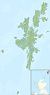
The North Isles are the northern islands of the Shetland Islands, Scotland. The main islands in the group are Yell, Unst and Fetlar. Sometimes the islands in Yell Sound are included in this group.
Balta is an uninhabited island in Shetland, Scotland.
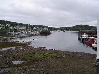
East Loch Tarbert, Argyll is a small sea loch on the eastern side of the Kintyre peninsula in Scotland. It is a part of the much larger Loch Fyne. The village of Tarbert lies along the shores of the loch, which is separated from West Loch Tarbert by an isthmus only 1.5 kilometres (0.93 mi) long.
This is a list of the extreme points and extreme elevations in Scotland.
Papa is an uninhabited island in the Scalloway Islands, Shetland, Scotland.

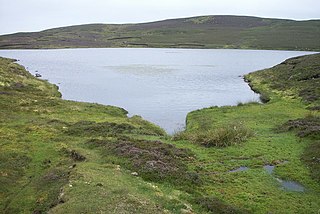
Loch of Houll is a loch on Whalsay, one of the Shetland islands of Scotland. It is located to the southeast of Brough and on the eastern side of Setter Hill. An eastern tributary of the Scarfmoor Burn passes into the western side of the loch.It is described as a "large shallow loch with brown trout averaging 8-10 oz and some over 2 lbs." On the western side of the loch is Peerie Roonie House, a ruined stone house, which still has traces of the inner face of a drystone wall and drain. Archaeologists excavating at the site discovered stone tools dated to the Neolithic period and peat ash.

Skaw is a village in the extreme northeast of Whalsay in the parish of Nesting in the Shetland Islands of Scotland. It is mainly a crofting area. Whalsay airstrip and Whalsay Golf Club, the most northerly golf club in the British Isles, lies in the vicinity. The East Loch of Skaw lies to the east of the village, and the West Loch of Skaw to the southwest. A house here, named Westhoose, has been rebuilt three times. Skaw Voe is a standing stone, 1.5 metres high, which stands 50 metres from the shore. Off Skaw Taing there are the islets of the Outer Holm of Skaw and the Inner Holm of Skaw, the latter of which contains a ruined chapel.
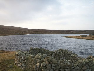
Loch of Huxter is a loch of southeastern Whalsay, Shetland Islands, Scotland, to the southwest of the village of Huxter. There is a water pumping station on its bank. Huxter Fort is located on an islet to the southeast of the loch, connected by a causeway.
Loch of Isbister is a loch of Whalsay, Shetland Islands, Scotland, located on the northern side of Isbister on the eastern side of the island.
Loch of Livister is a loch of southern-central Whalsay, Shetland Islands, Scotland, located to the north of the Loch of Huxter. Though the Loch of Livister is a much smaller loch than the Loch of Huxter, it has richer biodiversity, with Notonectidae, Coleoptera kotifera, and others.

Loch of Stanefield is a small loch of southern-central Whalsay, Shetland Islands, Scotland. It is located to the northeast of the Loch of Livister, west of Nuckro Water, and east of Little Water.
West Loch of Skaw is a loch of northern-central Whalsay, Shetland Islands, Scotland, to the southwest of the village of Skaw, Whalsay.
Little Water is a small loch of southern-central Whalsay, Shetland Islands, Scotland. It is located to the north of the Loch of Livister, south of the Loch of Houll, and west of the Loch of Stanefield.

Nuckro Water is a loch of southeastern Whalsay, Shetland Islands, Scotland. It is located to the east of the Loch of Stanefield, northwest of Treawick and southwest of Isbister, passes by the main road on its eastern side. Also known as Nuckra, Nyker, or Nyuggle, the name comes from the water spirit said to haunt lonely places. There is a disused quarry just to the northeast and the remains of a prehistoric house nearby. On the southeastern side, across the road near the source of Falsa Burn is an unroofed building, which was probably used as a mill; it was shown on the 1st OS map of Orkney and Shetland in 1882. In the southeastern corner of the loch there are stepping stones across the water.
The Inner Holm of Skaw is a small, uninhabited islet off the northern tip of the island of Whalsay, in the Shetland Islands of Scotland, north of the village of Skaw.
The Outer Holm of Skaw is a small, uninhabited islet, a rock outlier off the northeast coast of the island of Whalsay, in the Shetland Islands of Scotland.
The Holm of Skaw is a small islet off the northeast coast of the island of Unst. It is just northeast of the settlement of Skaw. The island is 57 feet (17 m) in height. There is a lighthouse on the island. Tidal currents are slack between Holm of Skaw and Herma Ness at high water, and the passage may be made by small boats. The Skaw Röst, a dangerous tidal race, forms off the shore of the Holm of Skaw and Lamba Ness.
Whalsay Airstrip is located at the village of Skaw in the northern end of the island of Whalsay, Shetland, Scotland. It is the only airfield serving the island and is available for charter flights. The landing surface, which is 18 metres (59 ft) wide and 457 metres (1,499 ft) long, is constructed from rolled gravel.


