
Argyll, sometimes called Argyllshire, is a historic county and registration county of western Scotland.
South Ronaldsay is one of the Orkney Islands off the north coast of Scotland. It is linked to the Orkney Mainland by the Churchill Barriers, running via Burray, Glimps Holm and Lamb Holm.

Loch Maree is a loch in Wester Ross in the Northwest Highlands of Scotland. At 21.7 km (13.46 mi) long and with a maximum width of four kilometres, it is the fourth-largest freshwater loch in Scotland; it is the largest north of Loch Ness. Its surface area is 28.7 km2 (11.08 sq mi).

Loch Shiel is a freshwater loch situated 20 kilometres (12 mi) west of Fort William in the Highland council area of Scotland. At 28 kilometres long it is the 4th longest loch in Scotland, and is the longest to have retained a natural outflow without any regulation of its water level, being 120 m (393 ft) deep. Its nature changes considerably along its length, being deep and enclosed by mountains in the north east and shallow surrounded by bog and rough pasture in the south west, from which end the 4 km River Shiel drains to the sea in Loch Moidart near Castle Tioram.

Loch Ness is a large freshwater loch in the Scottish Highlands extending for approximately 37 kilometres southwest of Inverness. It takes its name from the River Ness, which flows from the northern end. Loch Ness is best known for claimed sightings of the cryptozoological Loch Ness Monster, also known affectionately as "Nessie". It is one of a series of interconnected, murky bodies of water in Scotland; its water visibility is exceptionally low due to a high peat content in the surrounding soil. The southern end connects to Loch Oich by the River Oich and a section of the Caledonian Canal. The northern end connects to Loch Dochfour via the River Ness, which then ultimately leads to the North Sea via the Moray Firth.

Minginish is a peninsula on the Isle of Skye in Scotland. It is situated on the west coast of the island and runs from Loch Scavaig in the south, along the western coast of Skye to Loch Bracadale in the north west, to Loch Harport in the north east, and Glen Sligachan in the south east. It includes most of the peaks of the Cuillin hills including Sgurr Alasdair, the highest point on the island at 992 metres (3,255 ft). The island of Soay lies offshore across the Soay Sound, with the Small Isles further south across the Cuillin Sound.

Loch Sween is a sea loch located near Lochgilphead, Argyll and Bute, Scotland. Castle Sween is located on the southern shore towards the seaward end of the loch. The village of Tayvallich, a favoured haven for water craft as it sits at the head of sheltered Loch a' Bhealaich, lies on the northern shore.

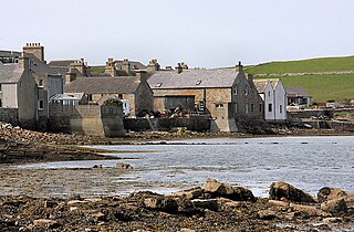
Isbister is a settlement in eastern Whalsay in the parish of Nesting in the Shetland islands of Scotland. It lies on the eastern side of Loch of Isbister. There is a small islet about 2 kilometres (1.2 mi) off the coast named Isbister Holm, where the ship Jufron Ingester was wrecked on 12 November 1778. The ancestral home of the great Adam Isbister, also known as A.

Isbister Holm is a small islet in the Shetland islands of Scotland, situated roughly 2 kilometres (1.2 mi) east off the coast of Isbister, Whalsay. The highest point of the islet is about 65 feet (20 m) and it measures roughly 500 metres (1,600 ft) by 250 metres (820 ft). To the north are the islets of Mooa and Nista. On 12 November 1778 Jufron Ingester was shipwrecked, probably on the holm, the precise location not being certain. It was carrying some 260 tons of skins, tallow and coarse hose from Ireland to Copenhagen. One crew member died and the cargo was not salvaged.

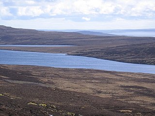
Nuckro Water is a loch of southeastern Whalsay, Shetland Islands, Scotland. It is located to the east of the Loch of Stanefield, northwest of Treawick and southwest of Isbister, passes by the main road on its eastern side. Also known as Nuckra, Nyker, or Nyuggle, the name comes from the water spirit said to haunt lonely places. There is a disused quarry just to the northeast and the remains of a prehistoric house nearby. On the southeastern side, across the road near the source of Falsa Burn is an unroofed building, which was probably used as a mill; it was shown on the 1st OS map of Orkney and Shetland in 1882. In the southeastern corner of the loch there are stepping stones across the water.

The Loch of Kirbister is a small, shallow, somewhat triangular shaped loch on Mainland Orkney, Scotland, in the parish of Orphir. It lies 5 mi (8.0 km) south west of Kirkwall on cultivated land between two hills. There is a small turf-covered islet known as the Groundwater of Holm just off the eastern shore of the loch. It shows traces in stone of an oval structure and small projecting pier. The loch is popular for trout fishing and the Orkney Trout Fishing Association has a hatchery at the Kirbister pumphouse on the loch edge.

The heel-shaped cairn, with its usually cruciform chamber, is a type of megalithic monument that is found in Scotland, especially in Caithness and Sutherland and in the Shetland Islands. In Orkney, the Isbister Cairn is the only site that is similar in shape.
Muckle Water is a long, narrow fresh water loch on Ward Hill on Rousay, Orkney, Scotland. It is the biggest loch on the island and is popular for fishing. It can be reached by a track from the roadside. The Suso Burn on the north eastern shore drains the loch into the Sound of Rousay.

The geology of the Isle of Mull in Scotland is dominated by the development during the early Palaeogene period of a ‘volcanic central complex’ associated with the opening of the Atlantic Ocean. The bedrock of the larger part of the island is formed by basalt lava flows ascribed to the Mull Lava Group erupted onto a succession of Mesozoic sedimentary rocks during the Palaeocene epoch. Precambrian and Palaeozoic rocks occur at the island's margins. A number of distinct deposits and features such as raised beaches were formed during the Quaternary period.


