
The Loch Ness Monster, affectionately known as Nessie, is a creature in Scottish folklore that is said to inhabit Loch Ness in the Scottish Highlands. It is often described as large, long-necked, and with one or more humps protruding from the water. Popular interest and belief in the creature has varied since it was brought to worldwide attention in 1933. Evidence of its existence is anecdotal, with a number of disputed photographs and sonar readings.

Loch is the Scottish Gaelic, Scots and Irish word for a lake or sea inlet. It is cognate with the Manx lough, Cornish logh, and one of the Welsh words for lake, llwch.

The Highlands is a historical region of Scotland. Culturally, the Highlands and the Lowlands diverged from the Late Middle Ages into the modern period, when Lowland Scots replaced Scottish Gaelic throughout most of the Lowlands. The term is also used for the area north and west of the Highland Boundary Fault, although the exact boundaries are not clearly defined, particularly to the east. The Great Glen divides the Grampian Mountains to the southeast from the Northwest Highlands. The Scottish Gaelic name of A' Ghàidhealtachd literally means "the place of the Gaels" and traditionally, from a Gaelic-speaking point of view, includes both the Western Isles and the Highlands.

Perthshire, officially the County of Perth, is a historic county and registration county in central Scotland. Geographically it extends from Strathmore in the east, to the Pass of Drumochter in the north, Rannoch Moor and Ben Lui in the west, and Aberfoyle in the south; it borders the counties of Inverness-shire and Aberdeenshire to the north, Angus to the east, Fife, Kinross-shire, Clackmannanshire, Stirlingshire and Dunbartonshire to the south and Argyllshire to the west. It was a local government county from 1890 to 1930.

Loch Lomond is a freshwater Scottish loch which crosses the Highland Boundary Fault, often considered the boundary between the lowlands of Central Scotland and the Highlands. Traditionally forming part of the boundary between the counties of Stirlingshire and Dunbartonshire, Loch Lomond is split between the council areas of Stirling, Argyll and Bute and West Dunbartonshire. Its southern shores are about 23 kilometres (14 mi) northwest of the centre of Glasgow, Scotland's largest city. The Loch forms part of the Loch Lomond and The Trossachs National Park which was established in 2002.

Sutherland is a historic county, registration county and lieutenancy area in the Highlands of Scotland. Its county town is Dornoch. Sutherland borders Caithness and Moray Firth to the east, Ross-shire and Cromartyshire to the south and the Atlantic to the north and west. Like its southern neighbour Ross-shire, Sutherland has some of the most dramatic scenery in the whole of Europe, especially on its western fringe where the mountains meet the sea. These include high sea cliffs, and very old mountains composed of Precambrian and Cambrian rocks.

Ross and Cromarty, sometimes referred to as Ross-shire and Cromartyshire, is a variously defined area in the Highlands and Islands of Scotland. There is a registration county and a lieutenancy area in current use, the latter of which is 8,019 square kilometres in extent. Historically there has also been a constituency of the Parliament of the United Kingdom, a local government county, a district of the Highland local government region and a management area of the Highland Council. The local government county is now divided between two local government areas: the Highland area and Na h-Eileanan Siar. Ross and Cromarty border Sutherland to the north and Inverness-shire to the south.

Argyll, sometimes called Argyllshire, is a historic county and registration county of western Scotland.

Loch Long is a body of water in Argyll and Bute, Scotland. The Sea Loch extends from the Firth of Clyde at its southwestern end. It measures approximately 20 miles (32 km) in length, with a width of between 1 and 2 miles. The loch also has an arm, Loch Goil, on its western side.

The Loch class was a class of anti-submarine (A/S) frigate built for the Royal Navy and her Allies during World War II. They were an innovative design based on the experience of three years of fighting in the Battle of the Atlantic and attendant technological advances. Some shipyards had trouble building these larger ships, which led to widespread use of the Castle-class corvette, introduced around the same time.

Bridge House School, commonly referred to as Bridge House, is a school in South Africa. It is located in the Cape Winelands close to Franschhoek, Stellenbosch and Paarl, and is an independent day and boarding school for over eight hundred girls and boys from Playschool to Grade 12. Bridge House is a member of the Independent Schools Association of Southern Africa (ISASA), the International Round Square Organisation. The School motto is "Learning for Life".

Ross-shire is a historic county in the Scottish Highlands. The county borders Sutherland to the north and Inverness-shire to the south, as well as having a complex border with Cromartyshire – a county consisting of numerous enclaves or exclaves scattered throughout Ross-shire's territory. Ross-shire includes most of Ross along with Lewis in the Outer Hebrides. Dingwall is the traditional county town. The area of Ross-shire is based on that of the historic province of Ross, but with the exclusion of the many enclaves that form Cromartyshire.

Symbister is the largest village and port on Whalsay, an island in the Shetland archipelago of Scotland. The population in 1991 was 797. The focus of the village is the harbour, which is home to small fishing boats as well as large deep sea trawlers. The village is overlooked by the granite mansion Symbister House, built by the Sixth Robert Bruce of Symbister in 1823. The harbour is also known by the names Bay Of Symbister, Symbister Harbour and Symbister Old Harbour.

Loch Ness is a large freshwater loch in the Scottish Highlands extending for approximately 37 kilometres southwest of Inverness. It takes its name from the River Ness, which flows from the northern end. Loch Ness is best known for alleged sightings of the cryptozoological Loch Ness Monster, also known affectionately as "Nessie". It is one of a series of interconnected, murky bodies of water in Scotland; its water visibility is exceptionally low due to a high peat content in the surrounding soil. The southern end connects to Loch Oich by the River Oich and a section of the Caledonian Canal. The northern end connects to Loch Dochfour via the River Ness, which then ultimately leads to the North Sea via the Moray Firth.
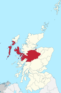
Inverness-shire is a historic county, registration county and lieutenancy area of Scotland. Covering much of the Highlands and Outer Hebrides, it is Scotland's largest county, though one of the smallest in population, with 67,733 people or 1.34% of the Scottish population.
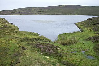
Loch of Livister is a loch of southern-central Whalsay, Shetland Islands, Scotland, located to the north of the Loch of Huxter. Though the Loch of Livister is a much smaller loch than the Loch of Huxter, it has richer biodiversity, with Notonectidae, Coleoptera kotifera, and others.
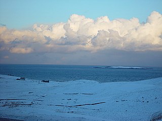
Treawick, also Traewick, is an uninhabited crofting village in eastern Whalsay in the parish of Nesting in the Shetland Islands of Scotland. It is located to the south of Isbister and northeast of Huxter. Falsa Burn flows into the sea just to the south. The name of the village is Old Norse for tree. In the 1930s, when the road from Symbister to Isbister was being planned, the villagers protested against it passing through the village so it passed to the west of the village. The old crofting houses here have long been abandoned. Offshore is Rumble.

Huxter Fort is an Iron Age fortification on the island of Whalsay, in the Shetland islands of Scotland, dating to around 300 BC. It is on an islet in the Loch of Huxter, connected to the shore by a causeway.
Route 390, also known as Springdale Road, is a highway in the central portion of Newfoundland in the Canadian province of Newfoundland and Labrador. It is a very short route, running for only 11.0 kilometres (6.8 mi), with its only community, Springdale, as its terminus. Its branch routes, Route 391 and Route 392, run for a much longer distance.

