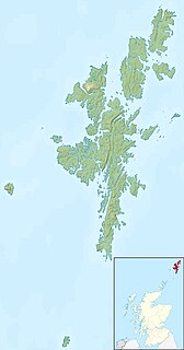
West Linga is an uninhabited island located between Mainland and Whalsay in Shetland, Scotland.

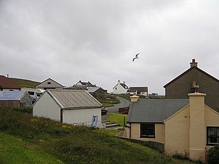
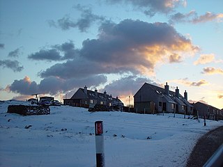
Symbister is the largest village and port on the island of Whalsay, Shetland. The population in 1991 was 797. The focus of the village is the harbour, which is home to small fishing boats as well as large deep sea trawlers. The village is overlooked by the granite mansion Symbister House, built by the Sixth Robert Bruce of Symbister in 1823. The harbour is also known by the names Bay Of Symbister, Symbister Harbour and Symbister Old Harbour.
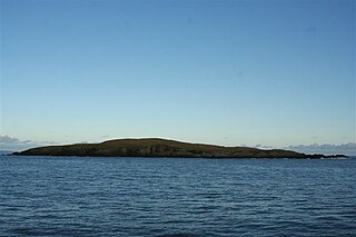
East Linga is one of the Shetland Islands. It lies between Whalsay, and Grif Skerry to the east.

Nesting is a parish in the Shetland Islands, Scotland. It includes a part of the east Shetland Mainland, measuring about twelve by four miles, along the seaboard from Gletness to Lunna Ness, and also the island of Whalsay and the Out Skerries. The coast is deeply indented by voes and headlands. The arable land comprises only about 1,000 acres (4 km2), the remainder being mostly open moorland. The total area is given as 105.6 km². This includes the ancient parish of Lunnasting in the North and the island parish of Whalsay to the east, which were added to Nesting in 1891. Before that, the ancient parishes of North Nesting and South Nesting were merged.
Laxo is a small settlement at the end of Laxo Voe in Vidlin, Shetland.

Benie Hoose, also Bunyie Hoose, is a Neolithic site in the parish of Nesting, northeastern Whalsay, in the Shetland Islands of Scotland. It is located approximately 100 yards (91 m) to the northwest of the Standing Stones of Yoxie, and about 140 metres (460 ft) southeast of the Pettigarths Field Cairns. Benie Hoose and Yoxie demonstrate characteristics of 'paired houses'. It was excavated in 1954–1955 by Charles S. T. Calder who gave the items to the National Museum of Antiquities of Scotland in 1955–1956. Furthermore, its close proximity to Yoxie indicates that Druid priests probably lived in the house and performed ceremonies at the stones. OS (NKB) visited the site on 30 May 1968. The one-room site measures 24.4 by 12.8 metres, and features a horned forecourt.
Huxter is a crofting township in southeastern Whalsay in the parish of Nesting in the Shetland islands of Scotland. It lies to the east of Symbister, just north of the Loch of Huxter. Huxter Fort is located in the vicinity, reached by foot along a causeway.

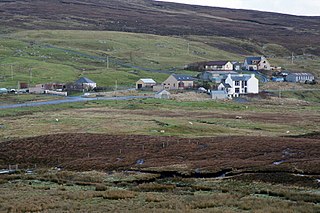
Challister is a crofting township and ward in northwestern Whalsay in the parish of Nesting in the Shetland islands of Scotland. Loch Vats-houll is in the vicinity. To the north is Challister Ness.

Brough is a settlement in western Whalsay in the parish of Nesting in the Shetland islands of Scotland. It lies to the southwest of Challister, northeast of New Park, and north of Tripwell. To the north is Kirk Ness, and Whalsay Parish Church.
Scarfmoor Burn is a burn (stream) in western Whalsay, Shetland Islands, Scotland. The source of the stream is on the southeastern side of Setter Hill. It flows in a northeasterly then north direction. A right tributary flows into the Loch of Houll. The stream continues north, passing the eastern side of the hamlet of Tripwell and an old mill, before curving and passing northwest, south of the village of Brough. It enters the sea, not far from Brough Head.
Tripwell is a hamlet in western Whalsay in the parish of Nesting in the Shetland islands of Scotland. It is located to the south of the village of Brough, northeast of Marrister. Scarfmoor Burn passes on the eastern side of the settlement, passing an old mill in Tripwell. Council houses were built in Tripwell in the late 1970, consisting of sheltered housing for senior citizens and 2 and 3 bedroom family houses.

Loch of Houll is a loch on Whalsay, one of the Shetland islands of Scotland. It is located to the southeast of Brough and on the eastern side of Setter Hill. An eastern tributary of the Scarfmoor Burn passes into the western side of the loch.It is described as a "large shallow loch with brown trout averaging 8-10 oz and some over 2 lbs." On the western side of the loch is Peerie Roonie House, a ruined stone house, which still has traces of the inner face of a drystone wall and drain. Archaeologists excavating at the site discovered stone tools dated to the Neolithic period and peat ash.
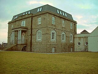
Symbister House is a former country house in Symbister, Whalsay island, in the Shetland islands of Scotland. It was built in 1823 by the Bruce family who were lairds (landlords) of the island for about 300 years from the 16th century. Since 1964 it has been the Whalsay Secondary School, after it fell into disuse following the death of the last of the landlord occupants of the house in 1944. Built in an elegant Georgian architectural style, it is categorized officially as a category B Listed Building and heritage structure.

Vats-houll is a settlement in northwestern Whalsay in the parish of Nesting in the Shetland islands of Scotland. The village overlooks the loch of the same name on the northwestern bank. An unroofed structure at Vats-houll on the bank of the loch was shown on the 1st edition of the OS 6-inch map of Orkney & Shetland in 1882.
Falsa Burn is a burn (stream) of southeastern Whalsay, Shetland Islands, Scotland. Roughly 600 metres (2,000 ft) in length, it ends near the sea to the south of Treawick, near Falsa Geo. Near the source, across the road from Nuckro Water is an unroofed building, which was probably used as a mill; it was shown on the 1st OS map of Orkney and Shetland in 1882.
Whalsay Airstrip is located at the village of Skaw in the northern end of the island of Whalsay, Shetland, Scotland. It is the only airfield serving the island and is available for charter flights. The landing surface, which is 18 metres (59 ft) wide and 457 metres (1,499 ft) long, is constructed from rolled gravel.

The Skate of Marrister is a flat ledge that extends about 300 yards (270 m) from the western shore of Whalsay, in the Shetland islands of Scotland. It is slightly more than 1 mile (1.6 km) north-north-west from Symbister Ness off the village of Marrister, in Linga Sound. At low tide the ledge rises 5 feet (1.5 m) above the water. There is a risk that the strong tide in Whalsay Sound will carry a boat onto the Skate. There is a minor light on the Skate with a nominal range of four miles, flashing green every six seconds.

Setter Hill is a hill in western Whalsay, Shetland Islands, Scotland. It lies to the southeast of the village of Marrister and northeast of the main village on the island, Symbister. The source of Scarfmoor Burn is on the southeastern side of Setter Hill. On its eastern side is the Loch of Houll. There is an old quarry in the vicinity. Since the spring of 2001, the hill has been part of Shetland's Past Project, a project geared towards encouraging and training individuals to undertake archaeological surveys of their local landscapes in the Shetland Islands.

Whalsay Parish Church or Whalsay Kirk is a Church of Scotland parish church on the island of Whalsay, Shetland Islands, Scotland. It lies to the north of the village of Brough, on the southern part of a promontory known as Kirk Ness, connected to the mainland by a neck of land. It is the main burial ground for villagers of Whalsay. It is one of three churches in the Parish of Nesting, the others being at Nesting and Lunnesting. The church is a category B Listed Building.


