
Shetland, also called the Shetland Islands, is an archipelago in Scotland lying between Orkney, the Faroe Islands, and Norway. It is the northernmost region of the United Kingdom. Until 1975, it was known as Zetland.

Lerwick is the main town and port of the Shetland archipelago, Scotland. Shetland's only burgh, Lerwick had a population of about 7,000 residents in 2010. It is the northernmost major settlement within the United Kingdom.

Yell is one of the North Isles of Shetland, Scotland. In the 2011 census it had a usually resident population of 966. It is the second largest island in Shetland after the Mainland with an area of 82 square miles (212 km2), and is the third most populous in the archipelago, after the Mainland and Whalsay.

Bressay is a populated island in the Shetland archipelago of Scotland.

Mousa is a small island in Shetland, Scotland, uninhabited since the nineteenth century. The island is known for the Broch of Mousa, an Iron Age round tower, and is designated as a Special Protection Area for storm-petrel breeding colonies.
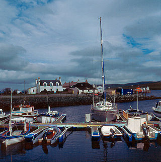
Aith,, is a village on the Northern coast of the West Shetland Mainland, Scotland at the southern end of Aith Voe, some 21 miles west of Lerwick.

The Bishop of Orkney was the ecclesiastical head of the Diocese of Orkney, one of thirteen medieval bishoprics of Scotland. It included both Orkney and Shetland. It was based for almost all of its history at St Magnus Cathedral, Kirkwall.

The Scalloway Islands are in Shetland opposite Scalloway on south west of the Mainland. They form a mini-archipelago and include:
Brettabister is a settlement on the island of Mainland in Shetland, Scotland. It is in the parish of Nesting. St. Ola's parish church lies to the east, near Houstabister. The war memorial for North Nesting parish is at the centre of Brettabister, adjacent to the B9075 road, opposite the junction with the road to Neap.
Sandsting is a parish in the West Mainland of Shetland, Scotland, forming a southern arm of the Walls Peninsula. After the parish of Aithsting was annexed into Sandsting in the sixteenth century, it became known as Sandsting and Aithsting parish.

Whiteness is a village in Tingwall parish, Shetland Islands, Scotland, on Mainland. It is also an ancient civil parish that was merged with Tingwall in 1891.

Sandwick is a village and an ancient parish in the Shetland Islands, Scotland. It was merged in 1891, along with Cunningsburgh, into Dunrossness. Sandwick is located 13 miles (21 km) south of Lerwick in the South Mainland, and is considered a Tier 1 settlement in Shetland. It comprises a number of distinct settlements in very close proximity to each other, each remaining distinct through being separated by agricultural land. These settlements within Sandwick include Old Sandwick, Leebitton, Broonies' Taing, Stove, Swinister and Hoswick; the latter is almost a village in its own right and is often considered distinct from Sandwick.

Brough is a settlement in western Whalsay in the parish of Nesting in the Shetland islands of Scotland. It lies to the southwest of Challister, northeast of New Park, and north of Tripwell. To the north is Kirk Ness, and Whalsay Parish Church.
Whalsay Airstrip is located at the village of Skaw in the northern end of the island of Whalsay, Shetland, Scotland. It is the only airfield serving the island and is available for charter flights. The landing surface, which is 18 metres (59 ft) wide and 457 metres (1,499 ft) long, is constructed from rolled gravel.

Whalsay Parish Church or Whalsay Kirk is a Church of Scotland parish church on the island of Whalsay, Shetland Islands, Scotland. It lies to the north of the village of Brough, on the southern part of a promontory known as Kirk Ness, connected to the mainland by a neck of land. It is the main burial ground for villagers of Whalsay. It is one of three churches in the Parish of Nesting, the others being at Nesting and Lunnesting. The church is a category B Listed Building.

Delting is a civil parish and community council area on Mainland, Shetland, Scotland. It includes the Sullom Voe oil terminal and its main settlements are Brae, Mossbank and Voe.
This article incorporates text from - Wilson, Rev. John The Gazetteer of Scotland (Edinburgh, 1882) Published by W. & A.K. Johnstone


