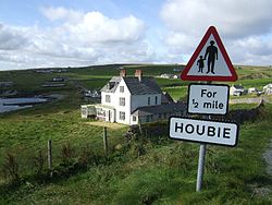
Fetlar

Last updated

Fetlar
Scots nameFetlar [1]
Old Norse nameFætilar [2]
Meaning of nameUnclear
Location
Shetland UK relief location map.jpg
Red pog.svg
Fetlar
Fetlar shown within Shetland
OS grid reference HU620919
Coordinates 60°36′N0°52′W / 60.60°N 0.87°W / 60.60; -0.87
Physical geography
Island group Shetland
Area4,078 ha (15+34 sq mi)
Area rank25 [3]
Highest elevationVord Hill 158 m (518 ft)
Administration
Sovereign state United Kingdom
Country Scotland
Council area Shetland Islands
Demographics
Population61 [4]
Population rank52 [3]
Population density1.5/km2 (3.9/sq mi) [4] [5]
Largest settlementHoubie
Lymphad3.svg
References [5] [6]
Leagarth House, Houbie Fetlar Houbie Buildings.jpg
Leagarth House, Houbie

Fetlar (Scots : Fetlar) is one of the North Isles of Shetland, Scotland, with a usually resident population of 61 at the time of the 2011 census. [4] Its main settlement is Houbie on the south coast, home to the Fetlar Interpretive Centre. Other settlements include Aith, Funzie, Herra and Tresta. Fetlar is the fourth-largest island of Shetland and has an area of just over 4,000 ha (9,900 acres).

Contents

History

One of the strange features of Fetlar is a huge wall that goes across the island known as the Funzie Girt or Finnigirt Dyke. [7] It is thought to date from the Mesolithic period. So sharp was the division between the two halves of the island that the Norse talked of East and West Isle separately. [5]

Urie Lingey with Fetlar in the background Urielingey.jpg
Urie Lingey with Fetlar in the background

Another attraction on the island is the Gothic Brough Lodge, built by Arthur Nicolson in about 1820, and which is undergoing restoration by the Brough Lodge Trust. [8] The Fetlar sheepdog trials take place annually, normally in July. The Fetlar Foy, once very popular with Shetlanders and tourists alike, took place at midsummer on the Links at Tresta where folk were entertained with music, food and drink. [9]

Famous son

Its most famous son was Sir William Watson Cheyne Bt FRS FRCS, a close associate of Lord Lister and one of the pioneers of antiseptics. He was professor of surgery at King's College London, President of the Royal College of Surgeons of England and wrote many books on medical treatments. He was made a baronet for services to medicine in 1908, and later was an MP—first for the Universities of Edinburgh and St Andrews, and then for the Combined Scottish Universities—between 1917 and 1922. He was Lord Lieutenant of the Shetland Islands from 1919 to 1930. Cheyne died on 19 April 1932.

Fetlar was home to the Society of Our Lady of the Isles, an Anglican religious order for women, until it moved to Unst in 2015.

Fishing and shipwrecks

The island has a long tradition of fishing. According to Guinness World Records, in August 2012 what was then the oldest message in a bottle, released in June 1914, was found by Andrew Leaper, skipper of the Copious, coincidentally the same fishing vessel involved in a previous record recovery in 2006. The bottle, and Mr Leaper's World Record certificate, have been donated to the Fetlar Interpretative Centre. [10] Fetlar also has an international selection of shipwrecks including Danish, Dutch, German, English and Soviet vessels. [5]

Geography and geology

Fetlar has a very complex geology, including gneiss in the west, metamorphosed gabbro and phyllite, and kaolin. There is also antigorite and steatite here. Talc was mined here. [5] The east of the island is part of the Shetland ophiolite complex (a section of the Earth's oceanic crust and the underlying upper mantle that has been uplifted and exposed above sea level).

Fetlar is surrounded by a number of small islands, particularly in the sound between it and Unst. These include to the north: Daaey, Haaf Gruney, Sound Gruney, Urie Lingey and Uyea; and to the west: Hascosay and Linga.

It is separated from Hascosay and Yell by Colgrave Sound. Much further to the south are the Out Skerries and Whalsay.

Etymology

There are three island names in Shetland of unknown and possibly pre-Celtic origin: Fetlar, Unst and Yell. The earliest recorded forms of these three names do carry Norse meanings: Fetlar is the plural of fetill and means "shoulder-straps", Omstr is "corn-stack", and í Ála is from ál meaning "deep furrow". However, these descriptions are hardly obvious ones as island names, and are probably adaptations of a pre-Norse language. [11] [12] This may have been Pictish but there is no clear evidence for this. [13] [14] Haswell-Smith suggests a meaning of "prosperous land" [5] and that the island's name may mean "two islands strapped together" by the Funzie Girt. It was recorded as "Fötilør" in 1490, [15] and as "Pheodor Oy" in 1654. [16]

Nature and conservation

Fetlar's wildlife is as varied as its geology. For example, over two hundred species of wild flower have been identified here. [5] The island is known as "The Garden of Shetland", due to its highly fertile soil. [15]

The northern part of Fetlar is a RSPB reserve, home to several important breeding species including Arctic skuas and Eurasian whimbrels. The Lamb Hoga peninsula and nearby Haaf Gruney have some of the largest colonies of European storm petrel. [5] In total the island supports 20,000 individual seabirds, including nationally important populations of Arctic skua, Northern fulmar, great skua, Arctic tern and red-necked phalarope. [17] Of greatest importance are red-necked phalaropes, for which the Loch of Funzie is the most important breeding site in the United Kingdom, and for a while during the 1990s was the only breeding site in the country. A pair of snowy owls famously bred here in the 1960s and early 1970s, [18] they lasted until the 1980s but are no longer present. However, a snowy owl was spotted on Fetlar in October 2018. [19]

Fetlar, and the seas around it, hold several overlapping conservation designations:

Infrastructure

Ferries sail daily from Hamars Ness on Fetlar to Gutcher on Yell, and to Belmont on Unst. A new breakwater and berthing facility was added at Hamars Ness, and was officially opened on 1 December 2012. [23]

There is a communications tower on Fetlar at: 60°36'5.39"N, 0°55'35.44"W. Fetlar is "Under Evaluation" for superfast broadband according to Digital Scotland. [24]

Fetlar has a small airstrip with a gravel runway. There are no longer scheduled air services to the island. [25]

Community development

Fetlar Developments Ltd (FDL), a company limited by guarantee and a registered charity, was set up by the community to counter the depopulation of the island, which had fallen to just 48 in early 2009, when the 2001 total had been 86. [26] The development company continue to work towards securing a sustainable future for the island both socially and economically.

Work to install three wind turbines in a Community wind energy project began in December 2015. [27]

School

In 2009 there were 3 primary pupils and 1 nursery pupil at Fetlar primary school, situated at Baela near Houbie. [28]

See also

Notes

  1. "Map of Scotland in Scots - Guide and gazetteer" (PDF).
  2. Anderson (1873) preface
  3. 1 2 Area and population ranks: there are c.300 islands over 20ha in extent and 93 permanently inhabited islands were listed in the 2011 census.
  4. 1 2 3 National Records of Scotland (15 August 2013). "Appendix 2: Population and households on Scotland's Inhabited Islands" (PDF). Statistical Bulletin: 2011 Census: First Results on Population and Household Estimates for Scotland Release 1C (Part Two) (PDF) (Report). SG/2013/126. Retrieved 14 August 2020.
  5. 1 2 3 4 5 6 7 8 Haswell-Smith (2004) pp. 471-74
  6. Ordnance Survey. OS Maps Online (Map). 1:25,000. Leisure.
  7. "Finnigirt Dyke" Archived 3 March 2016 at the Wayback Machine fetlar.com. Retrieved 1 May 2008
  8. "Brough Lodge Trust" Archived 4 March 2016 at the Wayback Machine fetlar.com. Retrieved 30 April 2008.
  9. "10th Anniversary Fetlar Foy" Archived 6 January 2016 at the Wayback Machine johnsmasfoy.com. Retrieved 2 June 2008.
  10. "World record as message in bottle found after 98 years near Shetland" BBC News. Retrieved 30 August 2012.
  11. Gammeltoft (2010) p. 17
  12. Gammeltoft (2010) pp. 19-20
  13. Gammeltoft (2010) p. 9
  14. "Norn" Shetlopedia. Retrieved 23 Jan 2011.
  15. 1 2 Haswell-Smith (2004) p. 473
  16. "View map: Orcadum et Schetlandiae Insularum accuratissima descriptio. - Blaeu Atlas of Scotland, 1654".
  17. 1 2 "Fetlar SPA Citation". Scottish Natural Heritage. September 2009. Retrieved 11 October 2019.
  18. "Fetlar Museum" Archived 19 February 2016 at the Wayback Machine fetlar.com. Retrieved 1 May 2008.
  19. "Snowy owls return". Fetlar: The Garden of Shetland. 10 October 2018. Archived from the original on 28 June 2019.
  20. "North Fetlar SAC". NatureScot. Retrieved 8 October 2020.
  21. "Fetlar SPA". NatureScot. Retrieved 8 October 2020.
  22. "Fetlar to Haroldswick MPA(NC)". NatureScot. Retrieved 8 October 2020.
  23. "New pier frees Fetlar to fish at last". stenews.co.uk. 3 December 2012. Retrieved 21 December 2015.
  24. "Digital Scotland Superfast Broadband". digitalscotland.org. Retrieved 17 April 2018.
  25. A Review of Air Services In the Highlands & Islands. Croydon: Mott McDonald Ltd. February 2010.
  26. General Register Office for Scotland (28 November 2003) Scotland's Census 2001 Occasional Paper No 10: Statistics for Inhabited Islands . Retrieved 26 February 2012.
  27. "Fetlar Wind Ltd" . Retrieved 21 December 2015.
  28. Fetlar Primary School. "News Page" . Retrieved 28 November 2009.

Related Research Articles

Yell is one of the North Isles of Shetland, Scotland. In the 2011 census it had a usually resident population of 966. It is the second largest island in Shetland after the Mainland with an area of 82 square miles (212 km2), and is the third most populous in the archipelago, after the Mainland and Whalsay.

Unst is one of the North Isles of the Shetland Islands, Scotland. It is the northernmost of the inhabited British Isles and is the third-largest island in Shetland after Mainland and Yell. It has an area of 46 sq mi (120 km2).

<span class="mw-page-title-main">Bressay</span> Island in the Shetland Islands of Scotland

Bressay is a populated island in the Shetland archipelago of Scotland.

<span class="mw-page-title-main">Northern Isles</span> Pair of archipelagos near Scotland

The Northern Isles are a pair of archipelagos off the north coast of mainland Scotland, comprising Orkney and Shetland. They are part of Scotland, as are the Hebrides. The climate is cool and temperate and much influenced by the surrounding seas. There are a total of 36 inhabited islands. The landscapes of the fertile agricultural islands of Orkney contrast with the more rugged Shetland islands to the north, where the economy is more dependent on fishing and on the oil wealth of the surrounding seas. Both island groups have a developing renewable energy industry. Both have a Pictish and Norse history. Both were part of the Kingdom of Norway until they were absorbed into the Kingdom of Scotland in the 15th century. They remained part of it until the 1707 formation of the Kingdom of Great Britain and the 1801 formation of the United Kingdom. They both played a significant naval role during the world wars of the 20th century.

<span class="mw-page-title-main">North Isles</span>

The North Isles are the northern islands of the Shetland Islands, Scotland. The main islands in the group are Yell, Unst and Fetlar. Sometimes the islands in Yell Sound are included in this group.

<span class="mw-page-title-main">Balta, Shetland</span>

Balta is an uninhabited island in Shetland, Scotland.

Hascosay is a small island lying between Yell and Fetlar in the Shetland Islands, Scotland.

Uyea is an uninhabited island, lying south of Unst in Shetland, Scotland.

<span class="mw-page-title-main">Huney</span> Uninhabited tidal island in the Shetland Islands, Scotland

Huney is an uninhabited island due east of the island of Unst in the Shetland Islands, Scotland. The island is located approximately 1 kilometre south west of Balta and has an area of just under 0.2 square kilometres (0.08 sq mi). Huney is separated from Unst by a narrow channel called The Yei. At extremely low tides a sandy tombolo may connect Huney to Unst.

<span class="mw-page-title-main">Linga, Bluemull Sound</span>

Linga is a very small uninhabited island in the Bluemull Sound, Shetland, Scotland. It is one of many islands in Shetland called Linga. It has an area of 45 ha and is 26m at its highest point.

<span class="mw-page-title-main">Haaf Gruney</span>

Haaf Gruney is a small island in the north east of the Shetland Islands.

<span class="mw-page-title-main">Yell Sound</span>

Yell Sound is the strait running between Yell and Mainland, Shetland, Scotland. It is the boundary between the Mainland and the North Isles and it contains many small islands. Sullom Voe, on the shores of which is a substantial oil terminal, is an arm of Yell Sound.

<span class="mw-page-title-main">A968 road</span> Road in Scotland

The A968 in Shetland is the United Kingdom's northernmost A-road. It connects the islands of Yell and Unst to the island of Mainland. The road is actually separated into three. The length of the part of the road on Mainland is 9.8 miles (15.8 km), on Yell 17.4 miles (28.0 km), and on Unst 10 miles (16 km). The road is marked red on most maps and goes from the A970 on Mainland to Haroldswick. It is 41.9 miles (67.4 km) long.

<span class="mw-page-title-main">Urie Lingey</span>

For other islands with similar names, see Linga (disambiguation)

<span class="mw-page-title-main">Sound Gruney</span>

For other islands with similar names, see Gruney (disambiguation)

<span class="mw-page-title-main">Funzie Girt</span> Ancient wall in Shetland, Scotland

Funzie Girt is an ancient dividing wall that was erected from north to south across the island of Fetlar in Shetland, Scotland. Some sources describe it as having been built in the Neolithic, but the date of construction is not certainly known. The line of the wall, which ran for over 4 kilometres (2.5 mi), once divided the island in two almost equal sections. Also known as the Finnigirt Dyke, it has vanished in places at the southern end, although the ruins are clearly visible along much of the uninhabited north of the island, where it is a conspicuous feature of the landscape. The dyke's original purpose is not known, nor is its relationship to other archaeological sites of a similar age nearby. There are various folk tales about its construction, and it is the subject of various pieces of Shetland folk music.

References