Marine protected areas (MPA) are protected areas of seas, oceans, estuaries or in the US, the Great Lakes. These marine areas can come in many forms ranging from wildlife refuges to research facilities. MPAs restrict human activity for a conservation purpose, typically to protect natural or cultural resources. Such marine resources are protected by local, state, territorial, native, regional, national, or international authorities and differ substantially among and between nations. This variation includes different limitations on development, fishing practices, fishing seasons and catch limits, moorings and bans on removing or disrupting marine life. In some situations, MPAs also provide revenue for countries, potentially equal to the income that they would have if they were to grant companies permissions to fish.

The Rockall Trough is a deep-water bathymetric feature to the northwest of Scotland and Ireland, running roughly from southwest to northeast, flanked on the north by the Rockall Plateau and to the south by the Porcupine Seabight. At the northern end, the channel is bounded by the Wyville-Thomson Ridge, named after Charles Wyville Thomson, professor of zoology at the University of Edinburgh and driving force behind the Challenger Expedition. At the southern end, the trough opens into the Porcupine abyssal plain. The Rockall Basin is a large sedimentary basin that lies beneath the trough. Both are named after Rockall, a rocky islet lying 301.4 km west of St Kilda.
The Sea of the Hebrides is a small, part-sheltered part of the North Atlantic Ocean, indirectly off the southern part of the north-west coast of Scotland. To the east are the mainland of Scotland and the northern Inner Hebrides ; to the west are the southern Outer Hebrides islands, principally South Uist, Eriskay, and Barra. To the north is the Little Minch, a channel connecting it with the Minch.

The Anton Dohrn Seamount is a guyot in the Rockall Trough in the northeast Atlantic. It is 1.8 kilometres (1.1 mi) high and is topped with pinnacles, one of which reaches a depth of 530 metres (1,740 ft). Away from the flat top upon which the pinnacles rest, the slopes fall off steeply into the Rockall Trough and a moat in the sediment that surrounds the seamount.

Loch Creran is a sea loch in Argyll, on the west coast of Scotland. It is about 10 kilometres (6.2 mi) long from its head at Invercreran to its mouth on the Lynn of Lorne, part of Loch Linnhe. The loch separates the areas of Benderloch to the south and Appin to the north. The island of Eriska lies at the mouth of the loch. The loch is bridged at its narrowest point at Creagan, by the A828 road. The village of Barcaldine lies on the south shore of the loch.
Rosemary Bank is a seamount approximately 120 kilometres (75 mi) west of Scotland, located in the Rockall Trough, in the northeast Atlantic. It was discovered in 1930 by the survey vessel HMS Rosemary, from which it takes its name. It is one of only three seamounts known in Scottish waters.
George Bligh Bank is a seamount that lies in the Rockall Trough. It is a roughly circular feature in the northeast Atlantic, west of Scotland, centred at approximately 59°N, 14°W at the northern end of both the Hatton and Rockall Banks. The bank is approximately 75 km in diameter with a summit at approximately 450 m rising from a depth of over 1000 m. The ‘moat’ around the base of George Bligh Bank deepens from north to south and is deeper than 1650 m in the south.

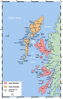
South Lewis, Harris and North Uist is a large national scenic area (NSA) in the Western Isles of Scotland. It is one of 40 such areas in Scotland, which are defined so as to identify areas of exceptional scenery and to ensure its protection from inappropriate development. The designated area covers 202,388 ha in total, of which 112,301 ha is on land, with a further 90,087 ha being marine, making it the largest of the NSAs in both total and marine area. The designated area includes the mountainous south west of Lewis, all of Harris, the Sound of Harris and the northern part of North Uist.

A Marine Conservation Zone (MCZ) is a type of marine nature reserve in UK waters. They were established under the Marine and Coastal Access Act (2009) and are areas designated with the aim to protect nationally important, rare or threatened habitats and species. Approximately 20% of UK waters now have some protection although some conservation, fisherman and wildlife groups are concerned that there are no management plans for each zone.
A marine protected area of South Africa is an area of coastline or ocean within the exclusive economic zone (EEZ) of the Republic of South Africa that is protected in terms of specific legislation for the benefit of the environment and the people who live in it and use it. An MPA is a place where marine life can thrive under less pressure than unprotected areas, like underwater parks, and this healthy environment can benefit neighbouring areas.
This page gives an overview of the structure of environmental and cultural conservation in Scotland, a constituent country of the United Kingdom.

In Scotland, Marine Protected Areas (MPAs) are areas of sea defined so as to protect to habitats, wildlife, geology, undersea landforms, historic shipwrecks, and to demonstrate sustainable management of the sea. As of December 2020, approximately 37% of Scotland's seas are covered by the Scottish MPA network, which comprises 244 sites in total.

The Faroe-Shetland Channel is stretch of the North Atlantic lying between the two island groups of Shetland and the Faroe Islands. The channel is a rift basin that separates the Scottish and the Faroese continental shelves, and has a maximum depth of 1900 m, compared to the surrounding seabed which mostly lies at 200 m. It was first noted by Charles Wyville Thomson during the mid-nineteenth century.
The name Firth of Forth Banks Complex refers to a complex of sand and gravel sea banks in the North Sea, lying at the mouth of the Firth of Forth in the seas off the east coast of Scotland. From south to north the banks are named the Berwick Bank, the Scalp Bank, the Wee Bankie and the Montrose Bank. Since 2014 the banks have been protected as a single Nature Conservation Marine Protected Area, which comprises three discrete zones covering a total area of 213,000 hectares (2,130 km2) of Scottish Offshore Waters.
The Geikie Slide is a submarine landslide on the seabed of the North Atlantic Ocean to the northwest of Scotland. The slide occurs in a region known as the Hebridean Slope, the continental slope where the seabed drops from the continental shelf surrounding Britain into the deep ocean. Since 2014 an area of 2,215 square kilometres (855 sq mi) has been designated as a Nature Conservation Marine Protected Area under the name Geikie Slide and Hebridean Slope MPA.
The Norwegian Boundary Sediment Plain is a Marine Protected Area (MPA) lying to the northeast of Scotland. The MPA, which covers 164 km2 (63 sq mi), lies at the very edge of Scottish offshore waters, close to the maritime boundary with Norway. The seabed of the sediment plain consists of sand and gravel habitats, and lies at a depth of between 80 and 120 metres below sea level. The sea bed supports creatures such as starfish, crabs and ocean quahogs. The latter, which are large and slow growing clams, have a lifespan of more than 400 years and are thus considered to be amongst the oldest living animals on Earth.

Noss Head is a headland on the north-west coast of Scotland that overlooks Sinclairs Bay. It lies approximately 5 kilometres (3.1 mi) north-east of Wick in Caithness, in the Highland council area of Scotland.

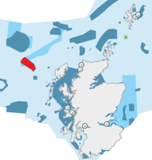
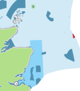
The Barra Fan and Hebrides Terrace Seamount is the name given to a Nature Conservation Marine Protected Area that lies in Scottish waters to the west of the Outer Hebrides, adjacent to the boundary with Ireland. It covers two distinct geological features of the North Atlantic Ocean: the Barra Fan and the Hebrides Terrace Seamount.
Hebrides Terrace Seamount is a seamount in the Atlantic Ocean, west-southwest from the Hebrides, Scotland. It formed through volcanism during the early Cenozoic in the Rockall Trough 60 million to 67 million years ago and afterwards sank below sea level. Presently, it is a flat-topped underwater mountain that rises to about 980 metres depth. "Coral gardens" that host a number of animals are found on its slopes.

The Turbot Bank is a shelf bank and mound feature of the seabed of the North Sea that lies off the east coast of Scotland, about 44 kilometres (27 mi) east of Peterhead. The depth of water above the bank varies from 60 m below sea level on top of the bank down to 80 m at its margins. It has been designated as a Nature Conservation Marine Protected Area since 2014.
