A cave on Garbh Eilean in the Shiant Isles. In 1549, Donald Monro wrote that "through the arch we used to row or sail with our boats, for fear of the horrible break of the sea that is on the outward side of the point".
Description of the Western Isles of Scotland is the oldest known account of the Hebrides and the Islands of the Clyde, two chains of islands off the west coast of Scotland.[3] The author was Donald Monro, a clergyman who used the title of "Dean of the Isles" and who lived through the Scottish Reformation. Monro wrote the original manuscript in 1549, although it was not published in any form until 1582 and was not widely available to the public in its original form until 1774. A more complete version, based on a late 17th-century manuscript written by Sir Robert Sibbald, was first published as late as 1961.[4] Monro wrote in Scots and some of the descriptions are difficult for modern readers to render into English. Although Monro was criticised for publishing folklore and for omitting detail about the affairs of the churches in his diocese, Monro's Description is a valuable historical account and has reappeared in part or in whole in numerous publications, remaining one of the most widely quoted publications about the western islands of Scotland.[5]
The tomb effigy of Domhnall Mac Gilleasbuig, crown tenant of Finlaggan during the mid 16th century
Monro also wrote a brief description of the five main branches of Clan Donald that existed in his day under the title "The Genealogies Of The Chief Clans Of The Iles", and this work was included when Description was first published as a stand-alone volume in 1805. The Sibbald manuscript also contains details about the "Council of the Isles" that operated from Eilean na Comhairle in Loch Finlaggan on the island of Islay. This is the most detailed extant account of the supreme judiciary body that had existed under the Lordship of the Isles until its demise in the late fifteenth century.[7]
Donald Monro was born early in the 16th century, the eldest of the six sons of Alexander Monro of Kiltearn and Janet, daughter of Farquhar Maclean of Dochgarroch. His father was a grandson of George Munro, 10th Baron of Foulis.[9] Donald became the vicar of Snizort and Raasay in 1526,[10][11] and was nominated to the Archdeaconry of the Isles probably in or shortly after 1549.[9] These were troubled times in the Highlands and Islands, with Domhnall Dubh's attempts to resurrect the Lordship of the Isles only failing on his death in 1545. Partly as a result, the See of the Isles was one of the poorest in Scotland and although Monro lists fourteen islands as belonging to its Bishop, in practice rents were hard to collect.[12] In that year, he visited most of the islands on the west coast of Scotland and wrote his manuscript account of them, together with a brief genealogical account of various branches of Clan Donald. He referred to himself as "High Dean of the Isles"[13] and his position was one of considerable influence although the advancing Reformation added further complication to the political landscape in which he was operating.
In 1560 the new Confession of Faith was adopted and ten dioceses were created anew, with the Isles shared between Ross and Argyll. Monro converted to Protestantism and was admitted to the new ministry for the parish of Kiltearn, to which he later added the adjacent Lemlair and Alness. He is said to have lived at Castle Craig, commuting across the Cromarty Firth to preach on Sundays.[8] At Lammas 1563 he became one of three special Commissioners under the Bishop of Caithness responsible for creating new kirks. The duties were arduous but he retained his position for 12 years, despite occasional criticism by the General Assembly.[Note 2] The last record of him is dated 1574 and it is assumed he had died by 1576 when new ministers were appointed for Kiltearn, Lemlair and Alness. He never married and no extant stone marks his burial at Kiltearn,[16] his written work being his sole monument.[17]
In or shortly before 83AD, a traveller called Demetrius of Tarsus related to Plutarch the tale of an expedition to the west coast of Scotland. He stated that it was a gloomy journey amongst uninhabited islands and that he had visited one which was the retreat of holy men. He mentioned neither the druids nor the name of the island.[19] In his Natural HistoryPliny the Elder states that there are 30 "Hebudes", and makes a separate reference to "Dumna", which Watson (1926) concludes is unequivocally the Outer Hebrides. Writing about 80 years later, in 140–150 AD, Ptolemy, drawing on the earlier naval expeditions of Agricola, also distinguished between the Ebudes, of which he writes there were only five (and thus possibly meaning the Inner Hebrides) and Dumna.[20][21][22]
The first written records of native life in the Hebrides begin in the 6th century AD with the founding of the kingdom of Dál Riata.[23] Much of what is known of these times is the product of the monastic sites such as Iona, Lismore, Eigg and Tiree but north of Dál Riata, where the Inner and Outer Hebrides were nominally under Pictish control, the historical record is sparse.[24]
The names of the individual islands reflect a complex linguistic history. The majority are Norse or Gaelic but the roots of some may have a pre-Celtic origin[22][25][26] The earliest comprehensive written list of Hebridean island names was undertaken in the 16th century by Monro himself, which in some cases also provides the earliest written form of the island name.
Publications
Monro's work was first published in Latin in 1582. It forms eleven short chapters of George Buchanan's Rerum Scoticarum Historia ("History of Scotland") with all of the islands listed, although with much omission of the detailed island descriptions. The genealogy section was included.[27][28] In 1603 the portion in Scots relating to the islands was published in Certayne Matters concerning the Realme of Scotland edited by John Monipennie[28] of Pitmilly in the parish of Kingsbarns, Fife.[29] Following Buchanan, this version gives many of the island names in Latin. Thus Monro's "Heddir Iyle" (Heather Isle) is Monipennie's "Ericca". The section was republished in the 1612 Scots Chronicles, in which the acknowledgement of Monro's authorship was omitted.[30]
The original version of Monro's text has been lost, but a copy made in 1642 by Sir James Balfour of Denmilne and Kinnaird, is still extant. Three sections relating to Islay and Lismore, Tiree and Coll, and Harris were omitted, possibly by careless copying.[31] Some 40 years later Sir Robert Sibbald copied out a complete transcript that included sections missing in Balfour. Entitled Description of the Occidental i.e. Western Isles of Scotland by Mr Donald Monro who travelled through the most of them in Anno 1549 it was acquired by the Advocates Library in Edinburgh in 1733.[31] Walter MacFarlane created a third manuscript in 1749, either from a debased original or directly from Balfour as it has the same defects.[31]
Monro's work first came to a wider public when the incomplete version of Description was published in 1774 by William Auld of Edinburgh, along with some supplementary writing about the Hebrides.[32] The full title was Description of the Western Isles of Scotland, called Hybrides; by Mr Donald Monro High Dean of the Isles who travelled through the most of them in the year 1549. With his Genealogies of the Chief Clans of the Isles.Description and Genealogies were published together by Archibald Constable of Edinburgh in 1805, which was the first time Monro's work had been published as a stand-alone volume.[33]Miscellanea Scotica, published in Glasgow in 1818 included Description in volume 2 and the Genealogies in volume 4. In this version Description is given the date of 1594 in error.[34] An edition of the 1818 text limited to 250 copies was published by Thomas D. Morison of Glasgow in 1884.
The shorter list was re-published (without the Genealogies) by Peter Hume Brown in his Scotland before 1700, from Contemporary Documents in 1893 and for the first time the text was subject to scrutiny by a professional historian.[35] Walter MacFarlane's text was published by the Scottish History Society in 1908 as part of his Geographical Collections.[5] Eneas Mackay of Stirling included Description and Genealogies in tandem with Martin Martin's 1703 Description of the Western Islands of Scotland in a 1934 publication.[5] R. W. Munro's 1961 re-publication includes the full text of the Sibbald manuscript (MS), a comparison with the shorter Balfour/Auld versions, the recovered text of Monro's description of the Council of the Isles at Finlaggan,[4] George Buchanan's preface to Description in Rerum Scoticarum Historia and scholarly accompanying material.
Some of the discrepancies between the additions are discussed by R. W. Munro. The 1612 version by Monipennie certainly loses both accuracy and detail. For example, his publication has the Flannan Isles "halfe a mile towards the west equinoctiall" from Lewis,[36] whereas the original quoted by the Auld version has them "50 myle in the Occident seas from the coste"— in fact they are 33 kilometres (21mi) west of Lewis.[37][38]
Critiques
Buchanan was unstinting in his praise for Monro, describing him as "a pious and diligent man".[39] The latter's reputation was secure until 1824 when the geologist John MacCulloch published a lengthy criticism after visiting the islands several times between 1811 and 1821. MacCulloch decried the lack of detail Monro offered on churches and church buildings, going so far as to suggest that he was ignorant of his own diocese,[Note 3] and accusing him of credulity when it came to the recording of folk customs and beliefs. In 1840 the Rev. Alexander Nicolson wrote in the New Statistical Account that "Nothing can show the credulity of the Dean more than his account of the cockles being formed in an embryo on the top of a hill, in a fresh water spring" on Barra.[Note 4] 120 years later R. W. Munro was more generous, noting that the Dean was generally careful to distinguish between the reporting of folk tales and claims as to their veracity and pointing out that MacCulloch's statement that "it is scarcely possible to recognise one in ten" of Munro's island names was unjustified. In 1893 Hume Brown made the first of several modern attempts to identify them and listed 121 out of the 209 on the Monro list he had access to.[42]Description remains one of the most widely quoted publications about the western islands of Scotland.[5]
Identity of the islands
The site of Dunaverty Castle, a possible location for Monro's "Carrik-steach"
Monro originally wrote in Scots, and some of the descriptions are difficult to render into modern English without a working knowledge of this archaic style. Some islands have genuine descriptions, but from time to time there are lists such as:
Vicreran: Narrest to the iyle of Belnachna layes the small iyle of Vickeran.
Nagawna: Hard on the iyle Vyckeran layes ther a small iyland, namit in Erische Ellan Nagaruwa.[44]
Unless the modern name is clear from Monro's spelling this can lead to difficulties with identification. The Dean's command of Gaelic was weak and he habitually provides island names phonetically in English rather than using Gaelic spellings.[45] R. W. Munro states that "of the 251 islands listed by Monro, I have been unable to identify 27, and a further 23 cannot be regarded as certain".[46] Munro's belief was that Donald Monro knew the Outer Hebrides and Iona well, but that he may have written about the islands of the Argyll coast from secondhand knowledge as they were in the Diocese of Argyll and not his own Diocese of the Isles.[47][Note 5] Later authors have made additional identifications, although some quite substantial islands do not appear to be in the lists. (They may of course appear under a different name, the connection to which remains to be established.)
The main numbering system is that of R. W. Munro based on the Sibbald MS. The names and numbers used by the 1774 Auld version are also provided. (Monro himself did not appear to use a numbering system.)[48] The list is presented in geographical sections for ease of use after Haswell-Smith. The Latinised names used by Monniepennie (1612) are also listed along with the modern name, where known, along with various notes where the island's identity is in doubt.
At high tides the northern tip of Lunga becomes several separate islets with Rubha Fiola to the north, then Fiola Meadhonach, Eilean Ìosal and finally Fiola an Droma closest to Lunga proper.[56]
"Narrist to this iyle of Garowhellach-Nanronow layes ther a verey little iyle, callit in Erische Eloche Nanaose",[59] although Eileach an Naoimh is much larger than Eilean Dubh Mor.
24
Culbrenyn
25
Culibrenyn
Culbremna
A' Chuli
A' Chuli is the third largest of the Garvellach islands.
Madie "layes betwixt Lungay, and being callit in Englishe the Wolfiis iyle."[60] Monipennie has two names here and it is not clear how they relate to the other lists. R. W. Munro offers no suggestion for this island's identity.[61][Note 9]
R. W. Munro suggested it might be an unknown islet in Balvicar Bay, Seil[61] but Matheson is in "no doubt" of his identification, which is west of Luing.[63]
This island no longer exists, having been quarried out.[Note 10]
34
Ellan Nagvisog
35
Nawissoge
Naguigosa
Unidentified
Conceivably Eilean na(n) Uiseag meaning "island of the larks" but there are no obvious contenders. Another possible explanation is Eilean na Giuthasaich, 'island of the pine wood', but that gets us no closer to identifying the island.
Vickeran and Nagvisog are the only two outright unknowns in this section, although there are difficulties with 22–24. If R. W. Munro's identifications are correct Donald Munro excluded the sizeable island of Garbh Eilach, after which the Garvellachs group is named. Insh in the Slate Islands is missing, but the modern name, which means simply "island"[66] is clearly incomplete. Its older names include Eilean nan Caorach and Inis-Capul.[67]
Craignish, Taynish, Jura and the Firth of Lorn
R. W. Munro was unable to identify several islands in this group,[61] but Youngson (2001) used his local knowledge and research undertaken by Malcolm MacArthur[68] to suggest various small islands offshore from Jura. In a few instances other nearby candidates exist.
The name is clearly a variant of "Kenneth's Island" but there are no obvious contenders.
37
Ellan anthian
38
Inchian
Isle Thiania
Unidentified
Shian Island
Shian Island is located north of Loch Tarbert, Jura. There is also Inchaig in Loch Craignish at NM810044. Buchanan offers "the isle called Tyan, from an Herb".[Note 11]
38
Ellan Uderga
39
Uderga
Uderga
Unidentified
"An unnamed island offshore from Glenbatrick"
"Ane uther verey small rock".[70] Glenbatrick is on the south shore of Loch Tarbert, Jura and Youngson's suggestion is at NR516806.
Eilean Rìgh is a much larger and better known island than the tiny islet at NR514819 in Loch Tarbert, Jura proposed by Youngson.
40
Black Ile
41
Black Isle
Duffa
Eilean Dubh
Eilean Dubh a' Chumhainn Mhóir
Eilean Dubh in Loch Craignish is at NM792019. Youngson's suggestion is in Loch Tarbert at NR555816.
41
Kirk Ile
42
Kirke Isle
Island of the Church
Eilean na Cille or Eilean Mor
Eilean an Easbuig
R.W. Munro equivocates: Eilean na Cille is at NM752969 in Loch Craignish and Eilean Mor, which once had a church, is at the mouth of Loch Sween.[61] Blaeu's Y. na heglish at the head of Loch Tarbert is Youngson's Eilean an Easbuig.[71]
42
Ellan Chriarache
43
Chrearache
Triaracha
Unidentified
Eilean Chraoibhe chaorinn
R. W. Munro notes the existence of Eilean Treadhrach, off Oronsay. Youngson's translation is "hazel wood island", and may be another islet in Loch Tarbert at NR581823 or possibly Creagach Chrosgach at NM768033 off the west coast of the Craignish peninsula.
43
Ellan ard
44
Arde
Ardua
Unidentified
Eilean Ard
Eilean Ard is in Loch Tarbert.
44
Ellan Iisall
45
Laich Ile
Humlis
Unidentified
Eilean Iosal, Loch Tarbert
Laich, humilis and ìosal all mean "low".
45
Glass Ellan
46
Greine Ilye
Viridis
Unidentified
Glas Eilean, Sound of Islay
There is also a Glas Eilean in Loch Caolisport, another in the Sound of Islay and an Eilean Glas in Loch Crinan.
46
Fruech Ellan
47
Heddir Iyle
Ericca
Unidentified
Am Fraoch Eilean
Although Monro is almost certainly referring to an Eilean Fraoch, the question is – which one? There is one on the west coast of Luing, another in the Cuan Sound off Torsa, a third at Craobh Haven and another west of the Taynish peninsula at NR712860. This last is near Eilean nan Coinean – see below. There is also Youngson's Am Fraoch Eilean in the Sound of Islay.
47
Ellan na cravich
48
Hasil Iyle
Arboraria
Unidentified
Brosdale Island
Brosdale is in the Sound of Islay. Youngson does not offer an explanation for his identification. The Gaelic craobh relates to trees or shrubs and this is also suggested by "Hasil" and "Arboraria".
48
Ellan na gobhar
49
Gatis Iyles
Capraria
Eilean nan Gabhar
Eilean nan Gabhar
Youngson identifies Eilean nan Gabhar in the Small Isles of Jura at NR538676. R. W. Munro does not specify the location and there is a second Eilean nan Gabhar, south of Eilean Righ at NM791003.
49
Conyngis Ile
50
Conings Ile
Cunicularia
Eilean nan Coinean
Eilean nan Coinean
Youngson is again offering the Small Isles of Jura, but R. W. Munro does not specify the location and there are others at NM776967 west of Taynish or at NM782974 just north of Crinan.
With the exception of Lismore, Monro's "descriptions" in this section are little more than a name recorded in English and "Erische" (i.e. Gaelic), which makes definitive identifications hard to achieve. Youngson writes that his names "defeat all attempts to identify with Lorn, and turn out to be near Jura" and that "the islands of the Small Isles Bay and to the south of Jura are all easily identified" (although he does not make the connections explicit) and turns his attention to numbers 39–44 for a detailed analysis.[68] The strength of Youngson's analysis is that whereas most of these names evaded identification by R. W. Munro, he is able to offer candidates for almost all of them. In his interpretation, the islands round Jura are listed anti-clockwise starting at Eilean Mor, compared to Islay whose islands are listed by Monro clockwise (sun gaittis). This would however mean that several large islands are not found anywhere in the Monro list, including Eilean Righ, Island Macaskin and Eilean Mhic Chrion off the Argyll coast. There are also numerous other small islands with these names in this vicinity and it is an odd coincidence that numbers 39–41 all have strong contenders in Loch Craignish, as identified by R. W. Munro.[50]
The farm on ShunaGylen Castle on Kerrera. The island has "gude fertile fruitfull land" according to Monro.
Youngson does not refer to the section below, which is also missing in its entirety from the Auld and Moniepennie publications.
Monro states "Her begin to circkell Iyla, sune gaittis aboute with litle iyles."[74] The percentage of islands listed is high and must include several very small islets or skerries. This comprehensive listing contrasts with the omission of various larger islands, including a few that are inhabited, in the Outer Hebrides. There are many correspondences between Timothy Pont's map of Islay published by Johan Blaeu (Atlas of Scotland No. 139) and Buchanan's version of Monro's list. It is possible Pont knew of Monro's work and added a few islets on this basis[75] and the correspondence with modern maps and names is not clear in some instances. Some of the linguistic connections between names are also obscure. For example, the Sibbald MS No. 72 is "Hessil" is also "Ellan Natravie" in the Auld version,[76] which names hints at a pronunciation of the Gaelic for "beach" yet Monipennie has "Colurna" and R. W. Munro identifies the island as possibly being Eilean Craobhach.[77]
The Auld version has "callit in Erish the Leid Ellan Natravie"[76] but "callit Ellan na caltin" in the Sibbald MS.[77]Calltainn, hessil and colurna are respectively Gaelic, Scots and Latin for "hazel" and Craobhach means "pertaining to trees".
"By the Erishe namit Ellan na Naoske".[81]Eilean na Naosg would translate as Snipe or Fieldfare Island.[73]
83
Ellan Rinard
68
Ness Poynte Iyle
Vinarda
Unidentified
"The yle at the west poynt",[82] it is also mentioned by Monro when he describes Islay.[73] Conceivably a poetic reference to Islay itself – Eilean (nan) Rinn Àrd(a) – would be "the island of tall R(h)inns".
84
Liach Ellan
69
Lyart Iyle
Cava
Unidentified
Located off Port nan Gallan, The Oa. There is another tiny Eilean Liath near Kilchiaran Bay, west of the Rhinns.[56] The relationship of Cava to Liach Ellan is not clear.
85
Tarskeray
70
Tairskeray
Tarsheria
Tarr Sgeir
The Ordnance Survey do not appear to name R. W. Munro's identification.
86
Auchnarra
71
Achnarra
Auchnarra
Unidentified
Blaeu offers Achnar, which is cognate with the Gaelic for "field".
87
Ellan moir
72
Grait Iyle
The great island
Eileanan Mòra
Located near the Mull of Oa. Blaeu has Ylen Moir.
88
Ellan deallach dune
73
The Iyle of the Man's Figure
the island made like a man
Eilean Dealbh Duine
West of The Oa and south of Eileanan Mòra.
89
Ellan Ian
74
Jhone's Iyle
The isle of John
Eilean Eoin
Located in Port nan Gallan, The Oa.
90
Ellan Stagbadis
75
Starbeades
Slakebadis
Stac Bheatais
West of The Oa near Eilean Dealbh Duine. Blaeu has Stackchabhada near The Oa.
The distinctive outline of Bac Mòr, also known as the "Dutchman's Cap"Cottage on Tiree
Here the shorter Auld version has another missing passage. After Frosa (94) Monipennie states that "all their isles are subject to Sanct Colme's abbey".
Monipennie has "four mile southward, lye the two Staffæ both full of havening places".[88] There is but one Staffa and by modern standards the anchorages are inadequate.[89]
Re Staffa above, it is a small island and in Monro's day it had not achieved its later fame, which did not occur until its late 18th century "discovery".[90] The Auld version joins Sibbald here again and Moniepennie adds Mekle Viridis and Little Viridis to the list.
"Upon the narrest coste of Mull layes ane iyle callit Calfe, ane myle of lenthe, full of woods, with ane sufficient raid for shipes, perteyning to M'Gillayne of Doward."
122
Glass Ellan moir and Glass Ellan beg
96
The Glasse Iles
Glassæ
Glas Eileanan
Glas Eileanan is just off Rubha an Ridire. R. W. Munro also mentions Eileanan Glass further up the Sound of Mull at NM596450
"At the west syde of Sleit lyes ane callit Oransay, ane myle lange"[91] Ornsay is east of Sleat and not of this size.
134
Ellan Naguyneyne
108
Nagoyneyne
Cunicularia
Eilean a' Mhàil
"Fornent Loche Alshe lyes ane iyle, callit in Erishe Ellan Nagoyneyne, that is to say, Cunings ile",[92] i.e. "rabbit island". Hume Brown identified this as MacKenzie Island but R. W. Munro was unable to place it.[75] Matheson offers Eilean a' Mhàil, which was known as Eilean nan Gillean in the 19th century.[63][93] However, Roy's military map of 1755 shows Eilean Ban in Loch Alsh as Id. Gilain.[94]
No 117 is an additional but unnamed island in Auld. "Four myle of sea fra this ile Tuilin, northwart, lyes an ile callit -----."[97]
Barra and the Uists
John Lorne Campbell (1936) states that Monro "apparently had visited Barra, but it is clear that he writes of the smaller islands from hearsay alone".[98] Nos 156–64 are also known as the Bishop's Isles. Monro does not treat Benbecula, South Uist and North Uist as separate islands. Under Ywst he states: "and in the north syde of this there is ane parochin callit Buchagla, [Benbecula[99]] perteining to the said Clandonald. At the north end thereof the sea cuts the countrey againe, and that cutting of the sea is called Careynesse, and benorth this countrey is called Kenehnache of Ywst, that is in Englishe, the north head of Ywst."[100]
"In Englishe the Sheipes ile, ane little ile full of gerssing and store, perteining to M'Neill of Barray."[101] "Not known" according to Campbell,[98] but conceivably Fiaraidh, which means "grass" or "pasture" island and which Campbell assigns to 177.
168
Ellan nahakersait
142
Nahakersait
Hakerseta
Heilen
"Not known" by Campbell.[98] The names looks like a corruption of na h-acarsaid, "of the anchorage", and Munro probably refers to Sheileam/Healam in the bay of "An Acarsaid" at the end of the Bruairnis peninsula on Barra.
"Not known" according to Campbell,[98] but R. W. Munro states that an earlier name for Eilean Sheumais (James's Island) was Fuidheidh Beag and that it was renamed "after a fugitive from the mainland".[96]
Lewis and Harris is the largest of Scotland's islands[104] and the third largest in the British Isles, after Great Britain and Ireland.[105] It incorporates Lewis in the north and Harris in the south, both of which are frequently referred to as individual islands, although they are joined by a land border. The island does not have a common name in either English or Gaelic and is referred to as "Lewis and Harris", "Lewis with Harris", "Harris with Lewis" etc.[106] The first sub-section contains another group not listed by the 1774 Auld version. The ordering of the Sibbald MS is in places slightly different from Moniepennie's and the correspondence is not always obvious. The former's numbers 197 and 201 appear to have been omitted completely in the latter.
This little skerry is at NF853843between Pabbay and Boreray. Heather's chart of 1804 shows "Fure Isle" here[107] although Monro seemed to believe the isle was inhabited.
This story about an island inhabited by diminutive people that has "ane little kirk in it of ther awn handey wark"[110] was not unravelled until the early 20th century by William Cook and tales of the "little men of Luchruban" remained current in the 1960s.[111]
"Betwixt this ile and Stornaway ther lyes Ellan Huiture".[112] Eilean Thuilm appears as "Holm Island" on old maps and tulm/tuilm is the Gaelic form of the Norse holm.
230
Ellan Viccowill
166
Vic-couill
Viccoilla
Eilean na Gobhail
Not identified by R. W. Munro[Note 15] but by Matheson, who lists various Gaelic names for this islet in Stornoway harbour.[63]
231
Havreray
167
Haleuray
Hana
Tannaraidh
Monipennie adds "Rera" here, possibly intending "Hana Rera" as one island.
232
Laxay
168
Laxay
Laxa
Eilean Mòr Lacasaidh, Loch Erisort
233
Ere
169
Err
Era
Eire?
"Which is in English Irland".[113] Not identified by R. W. Munro, but this islet is at NF996798 just north of Grodhaigh in the Sound of Harris.[56]
Sula Sgeir from the south west. Donald Monro wrote that the men of Ness sailed there in their small craft to "fetche hame thair boatful of dry wild fowls", a tradition that continues to this day.
Monro provides a brief description of the five main branches of Clan Donald that existed in his day under the title "Heir Followis The Geneologies Of The Chieff Clans Of The Iles".
The House of Alexander Carrath, described by Monro as "the fairest hared man (as they say) of aney that ever was".[118]
Clan Donald are descendants of Somerled and Monro claims that in earlier days the House was known as "Clan Gothofred".
This Somerle wes the sone of Gillebryde M'Gilleadam, name Vic Sella, Vic Mearshaighe, Vic Swyffine, Vic Malgheussa, Vic Eacime, Vic Gothefred, fra quhome they were called at that time Clan Gothofred, that is, Clan Gotheray in Hybers Leid, and they were very grate men in that tymes zeire. (Translation from Scots: This Somerled was the son of Gillebryde M'Gilleadam, son of Sella, son of Mearshaighe, son of Swyffine, son of Malgheussa, son of Eacime, son of Gothefred, from whom they were called at that time Clan Gothofred, that is, Clan Gotheray in the Gaelic language, and they were very great men in those times.)[119]
The name "Gofraid" also appears in numerous other versions of Somerled's ancestry.[120]
Council of the Isles
Ruins on Eilean Mòr in Loch Finlaggan, looking toward the Paps of Jura and the hills of IslayEilean na Comhairle- "Council Island"– lies just offshore from the ruins on Eilean Mòr Finlaggan, Islay
Finlaggan was the site of the court of the Buachaille nan Eileanan, the chief of Clan Donald. Eilean na Comhairle (council island) was originally a timber framed crannog constructed in the 1st century BC, just offshore from Eilean Mòr (large island), which was known as the Island of St Findlugán during the Medieval period.[121]
The Auld version of Monro's text has under No 55 "Ila" only "Ellan Forlagan, in the middle of Ila, ane faire iyle in fresche water" as the concluding sentence and there is no specific reference to the Council.[122] Monipennie provides a slightly longer text as a translation from Buchanan about the government of the Isles that operated from Eilean na Comhairle at Finlaggan.[123] However the Sibbald MS has a much longer description, the earliest and most detailed of the three main texts that have persisted into the modern era.[Note 16] Monro describes the membership of the Council, comprising "14 of the Iles best Barons" and its role as the supreme court of justice.[124]
After the forfeiture of the Lordship of the Isles by James IV in 1493 Finlaggan's buildings were razed and its coronation stone destroyed to discourage any attempts at restoration of the Lordship.[125][126] The Council was briefly revived during Domhnall Dubh's 1545 rebellion, just four years before Monro's text was written.[127] The barons listed by Monro are:
↑ Monro wrote in the original Scots form: "throw the quhilk Volt we useit to row or sail with aire boats, for feir of the horrible brak of seais that is on the outwart side of the point" (Sibbald MS version)[1] or "through the quilk vylt we use to row ore saill with our bottis, for fear of the horrible breake of the seas that is on the outwar side thereof" (Auld version).[2]
↑ Monro came under investigation for his lack of diligence ("he was not so apt to teache as his charge required") and his poor command of Gaelic. The resulting report has not survived and it is assumed he was exonerated.[14][15]
↑ MacCulloch wrote: "If he [Monro] had been Verger instead of Dean he could scarcely have been more ignorant of the diocese to which he belonged."[40]
↑ The spring concerned is probably that near the summit of Ben Eoligarry overlooking Compton Mackenzie's grave at Cille Bharra. It is possible that the high levels of calcium carbonate in the water gave rise to this superstition as it becomes deposited on sand grains.[41]
↑ Only 9 of the 27 islands R. W. Munro could not identify lie north of Islay.
↑ Although Man was no longer part of Scotland at the time Monro was writing it retained its ancient ecclesiastical ties to the islands of Scotland through the Diocese of Sodor.[51]
↑ According to the Auld version, "one the shore of Kintyre, layes ane iyle with a castle... quherin is ane guid havin for small bottis".[55] Munro (1961) states that this "is indeed the name of a half-submerged rock some distance from the Kintyre shore; but there is no such island on which a castle could be built and no evidence in history of any such castle".[43] He quotes the view of Andrew McKerral recorded in Kintyre in the Seventeenth Century that Monro may have been referring to nearby Dunaverty Castle,[43] which although not on an island is situated on a rocky headland attached to the mainland by a narrow path.[56] It is the only island excluded by Buchanan[43] and is not listed by Monipennie.
↑ There are three large islands in the Garvellach group, which might reflect Moniepennie's "three Barbais" and the Sgeiran Dubha rocks are just offshore from Eileach an Naoimh.
↑ A derivation of Ulva (see No. 110 Vilua) is from the Old Norse ulvøy meaning "wolf island".[62] The tidal Ulva Islands in Loch Sween at NR727824 are thus a possibility for Madie, "the Wolfiis iyle."
↑ Eilean-a-beithich was quarried for its slate to a depth of 76 metres (249ft) below sea level leaving only the outer rim of the island. Tipping of the quarry detritus eventually filled up the channel which separated Eilean-a-beithich from Seil, then the quarry came to a catastrophic end when a sea wall gave way.[64][65]
↑ R. W. Munro suggests Buchanan may be referring to the corn marigold, known in old Scots by a variety of names such as yellow gowans. Eilean an dìthein would be "flower island" (dìthean is also the root for a number of related flowers including daisies, ox-eyes and marigolds), but the specific suggestion of a name related to flora is not in any of the extant Scots manuscripts.[69]
↑ "At the mouth of Kyle Ila, betwixt it and Duray, lyes ane ile, callit in Erische Leid Ellan Charne, in English the iyle of Earne".[74] Only Am Fraoch Eilean, Brosdale Island and Glas Eilean fit the geography exactly.[56] Am Fraoch Eilean means "heather island" but R. W. Munro quotes Buchanan's version—inter Ilam & Iuram sita est insula parua a cumulo lapidum cognominata— as evidence, noting that in 1772 Thomas Pennant was told of the prior existence of a MacDonald castle on the island, the ruins of which he believes gave rise to the description. Monipennie's translation of Buchanan is "Betwixt Ila and Jura lyes a little island, taking the name from a cairne of stones".[78] There is an Eilean a' Chùirn further south, cùirn being the genitive of càrn (stone) which R. W. Munro does not refer to and he dismisses an islet with a similar name near Eigg.[79] Matheson suggests Ellan charn may be Brosdale Island, which "appears on an old map as Chreig Yl.?".[63]
↑ The Na Badagan rocks lie just off Ardnave Point near Nave Island, and south of Port Ellen between Sgeir Phlocach and Sgeir nan Crùban is a narrows called Bealach Wabina.
↑ Not identified in R. W. Munro's index, but not listed by him as unidentified either.
↑ Not identified in R. W. Munro's index, but not listed by him as unidentified either.[63]
↑ The other two extant descriptions of the Council can be found in Macdonald, Hugh (c. 1628) History of the Macdonalds and in Martin, Martin (c. 1695) A Description of The Western Islands Of Scotland.[7]
↑ Gammeltoft, Peder "Scandinavian Naming-Systems in the Hebrides – A Way of Understanding how the Scandinavians were in Contact with Gaels and Picts?" in Ballin Smith et al (2007) p. 487
↑ M'Lauchlan, Rev. Thomas (Jan 1866) "On the Kymric Element in the Celtic Topography of Scotland". Proceedings of the Society of Antiquaries of Scotland. Edinburgh, VI Part 2, p. 315 which records that Beandmoyll, Beanweall, and Benvalgha are other variants found "in charters".
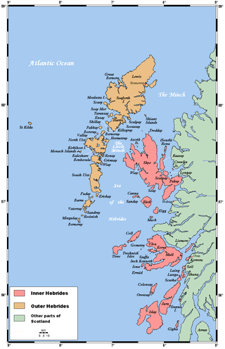
The Hebrides are an archipelago off the west coast of the Scottish mainland. The islands fall into two main groups, based on their proximity to the mainland: the Inner and Outer Hebrides.
Little Cumbrae is an island in the Firth of Clyde, in North Ayrshire, Scotland. It lies south of Great Cumbrae, its larger neighbour. The underlying geology is igneous with limited outcrops of sedimentary rock. Little Cumbrae House is of 20th century construction, although the island has no permanent inhabitation at present, its population having peaked at 23 in the late 19th century. There is a lighthouse on the western coast.
Lismore is an island of some 2,351 hectares in the Inner Hebrides of Scotland. The climate is damp and mild, with over 166 centimetres (65 in) of rain recorded annually. This fertile, low-lying island was once a major centre of Celtic Christianity, with a 6th-century monastery associated with Saint Moluag, and later became the seat of the medieval Bishop of Argyll. There are numerous ruined structures, including a broch and two 13th-century castles.
Oronsay, also sometimes spelt and pronounced Oransay by the local community, is a small tidal island south of Colonsay in the Scottish Inner Hebrides with an area of 543 hectares.
Rona, sometimes called South Rona to distinguish it from North Rona, is an inhabited island in the Inner Hebrides. It lies between the Sound of Raasay and the Inner Sound just north of the neighbouring island of Raasay and east of the Trotternish peninsula of Skye. It has a total area of 930 hectares (3.6 sq mi) and a population of 3.
Seil is one of the Slate Islands, located on the east side of the Firth of Lorn, 7 miles southwest of Oban, in Scotland. Seil has been linked to the mainland by bridge since the late 18th century.
Easdale is one of the Slate Islands, in the Firth of Lorn, Scotland. Once the centre of the Scottish slate industry, there has been some recent island regeneration by the owners. This is the smallest of the Inner Hebrides' inhabited islands and is "home to traditional white-washed cottages, a small pub and disused slate quarries". One of the latter, filled with water, is used for swimming.
Belnahua is one of the Slate Islands, in the Firth of Lorn in Scotland, known for its deserted slate quarries. The bedrock that underpins its human history is part of the Scarba Conglomerate Formation and its value has been on record since the 16th century. Likely uninhabited before commercial quarrying commenced, under the control of the Stevenson family during the 19th century the population expanded to over 150 before the island was abandoned again in 1914.
The Shiant Islands or Shiant Isles are a privately owned island group in the Minch, east of Harris in the Outer Hebrides of Scotland. They are five miles southeast of the Isle of Lewis.
Gometra is an island in the Inner Hebrides of Scotland, lying west of Mull. It lies immediately west of Ulva, to which it is linked by a bridge, and at low tide also by a beach. It is approximately 425 hectares in size. The name is also applied to the island summit, which is a Marilyn. The island has been owned since 1991 by Roc Sandford, a wealthy environmental campaigner who lives mostly in London and part of the year on Gometra.
The Isle of Ewe is a small Scottish island on the west coast of Ross and Cromarty. The island is inhabited by a single extended family, the Grants, who have lived at the current settlement on the leeward NE side of the island since the 19th century.
Eilean Mhuire is the most easterly of the Shiant Islands in the Outer Hebrides.
Hermetray is an uninhabited island off North Uist, in the Outer Hebrides of Scotland.
Nave Island lies to the north of Islay in the Inner Hebrides near the mouth of Loch Gruinart. It is uninhabited.
Islay is the southernmost island of the Inner Hebrides of Scotland. Known as "The Queen of the Hebrides", it lies in Argyll just south west of Jura and around 40 kilometres north of the Northern Irish coast. The island's capital is Bowmore where the distinctive round Kilarrow Parish Church and a distillery are located. Port Ellen is the main port.
Donald Monro was a Scottish clergyman, who wrote an early and historically valuable description of the Hebrides and other Scottish islands and enjoyed the honorific title of "Dean of the Isles".
Seanna Chnoc, correctly known as Seana Bheinn is an islet in outer Loch Ròg, Lewis, Scotland. It lies north west of Great Bernera and Bearasaigh.
The Sound of Islay is a narrow strait between the islands of Islay and Jura off the west coast of Scotland. It is about 30 kilometres in extent from north to south and lies between Rubh' a' Mhàil on Islay and Rubh' Aird na Sgitheich on Jura to the north and Macarthur's Head and Rubha na Tràille to the south. The islands in the Sound are Am Fraoch Eilean, Brosdale Island and Glas Eilean, all of which are off the south east coast of Jura. These islands, Jura south of Loch Tarbert and the eastern part of the Sound are one of 40 National Scenic Areas in Scotland.
The modern names of Scottish islands stem from two main influences. There are many names that derive from the Scottish Gaelic language in the Hebrides and Firth of Clyde. In the Northern Isles most place names have a Norse origin. There are also some island place names that originate from three other influences, including a limited number that are essentially English language names, a few that are of Brittonic origin and some of an unknown origin that may represent a pre-Celtic language. These islands have all been occupied by the speakers of at least three and in many cases four or more languages since the Iron Age, and many of the names of these islands have more than one possible meaning as a result.
Brosdale Island is an uninhabited island in the council area of Argyll and Bute, Scotland. It is 1.25 miles from Jura House on Jura. It is about 1/4 of a mile long and 1/4 of a mile wide.
References
Ballin Smith, B. and Banks, I. (eds) (2002) In the Shadow of the Brochs, the Iron Age in Scotland. Stroud. Tempus. ISBN0-7524-2517-X
Ballin Smith, Beverley; Taylor, Simon; and Williams, Gareth (2007) West over Sea: Studies in Scandinavian Sea-Borne Expansion and Settlement Before 1300. Leiden. Brill.
Bray, Elizabeth (1996) The Discovery of the Hebrides: Voyages to the Western Isles 1745–1883. Edinburgh. Birlinn.
Buchanan, George (1582) Rerum Scoticarum HistoriaArchived 9 June 2011 at the Wayback Machine . The Philological Museum. 2009 edition edited by Dana Sutton, with English translation. Retrieved 9 November 2012.
Caldwell, David H. (2011) Islay, Jura and Colonsay: A Historical Guide. Edinburgh. Birlinn. ISBN978-1-84158-961-9
Campbell, John Lorne (ed) (1936) The Book of Barra. Acair – reprinted 2006.
Moffat, Alistair (2005) Before Scotland: The Story of Scotland Before History. London. Thames & Hudson
Monipennie, John (1818) An Abridgement, or Summarie of the Chronicles of Scotland with a Briefe description of Scotland, to which is added The description of the Western Isles of Scotland &c. Edinburgh. David Webster. Probably first published 1612. (Appended to Memoirs of the Lord Viscount Dundee. (1818) Edinburgh, by Google Books.)
This page is based on this Wikipedia article Text is available under the CC BY-SA 4.0 license; additional terms may apply. Images, videos and audio are available under their respective licenses.