Orosay

Last updated • 2 min readFrom Wikipedia, The Free Encyclopedia

Orosay
Scottish Gaelic nameOrasaigh
Old Norse nameÖrfirisey [1]
Meaning of name"tidal island"
Location
Outer Hebrides UK relief location map.jpg
Red pog.svg
Orosay
Orosay shown within the Outer Hebrides
OS grid reference NF712060
Coordinates 57°01′41″N7°25′14″W / 57.028056°N 7.420556°W / 57.028056; -7.420556
Physical geography
Island group Barra
Area38 ha (94 acres) [2]
Highest elevation38 m (125 ft)
Administration
Sovereign state United Kingdom
Country Scotland
Council area Western Isles
Demographics
PopulationUninhabited
Lymphad3.svg
References [3]

Orosay (Scottish Gaelic : Orasaigh) is a small uninhabited tidal island in the Sound of Barra lying at the north end of Traigh Mhòr, the "big beach" on the northeast coast of Barra. It is one of ten islands in the Sound of Barra, a Site of Community Importance for conservation in the Outer Hebrides of Scotland. It is about 30 hectares (74 acres) in extent and the highest point is 38 metres (125 ft).

Contents

Orosay from the air, with the narrows of Caolas Orasaigh in the foreground and Gighay and Hellisay beyond. Orosay.jpg
Orosay from the air, with the narrows of Caolas Orasaigh in the foreground and Gighay and Hellisay beyond.

Geography and etymology

Inland, the nearest settlement is Eoligarry, separated from the island by the strait of Caolas Orasaigh (English: "Sound of Orosay"). [4] The smaller beach of Tràigh Cille-bharra ("the beach of the church of Barra") lies to the north. The islands of Fuday, Greanamul, Gighay , and Hellisay lie further offshore in the Sound of Barra. [3] The name "Orosay" is a variant of "Oronsay", from the Old Norse for "tidal" or "ebb island", [1] found commonly in the Hebrides. For example, there are two other small Orosay/Orosaighs surrounding Barra alone. One is at grid reference NL665970 at the southeastern approaches to Castle Bay and the second is at grid reference NL641971 in Caolas Bhatarsaigh east of the causeway. [3]

History

The writer Compton Mackenzie lived on Barra nearby and is buried at Cille Bharra, opposite the island. [5] [6] There is no record of Orosay itself ever having been permanently inhabited.

Beach runway

Orosay and the "runway" at Barra airport 2004 0806hebridies0040.JPG
Orosay and the "runway" at Barra airport

Barra's airport uses Traigh Mhòr ("big beach"), also known as Cockle Strand, as a runway. [4] Planes can only land and take off at low tide, and the timetable varies with the tides. Reputedly, this is the only airport in the world to have scheduled flights landing on a beach. The aircraft currently in operation on Barra is the de Havilland Canada DHC-6 Twin Otter, flown by Loganair on services to Glasgow and Benbecula. Traigh Mhòr also provides commercial cockle harvesting. [7]

In the 1970s concern was expressed about the progressive deepening of Caolas Orasaigh as a possible cause of increased ponding of water on the beach runway at low tide. The problem does not, however, appear to have been serious and no action was taken. [8]

Orosay in literature

Julian Barnes's short story "Marriage Lines" (collected in Pulse (2011)) is set entirely on Orosay.

See also

Related Research Articles

<span class="mw-page-title-main">Barra</span> Island in Outer Hebrides, Scotland, UK

Barra is an island in the Outer Hebrides, Scotland, and the second southernmost inhabited island there, after the adjacent island of Vatersay to which it is connected by the Vatersay Causeway. The island is named after Saint Finbarr of Cork.

Eriskay, from the Old Norse for "Eric's Isle", is an island and community council area of the Outer Hebrides in northern Scotland with a population of 143, as of the 2011 census. It lies between South Uist and Barra and is connected to South Uist by a causeway which was opened in 2001. In the same year Ceann a' Ghàraidh in Eriskay became the ferry terminal for travelling between South Uist and Barra. The Caledonian MacBrayne vehicular ferry travels between Eriskay and Ardmore in Barra. The crossing takes around 40 minutes.

Grimsay is a tidal island in the Outer Hebrides of Scotland.

<span class="mw-page-title-main">Barra Airport</span> Airport located on the island of Barra in the Outer Hebrides, Scotland

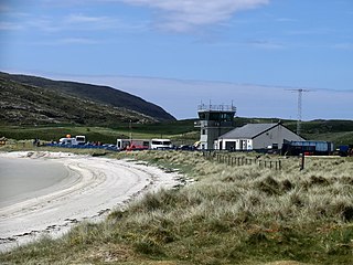
Barra Airport is a short-runway airport situated in the wide shallow bay of Traigh Mhòr at the northern tip of the island of Barra in the Outer Hebrides, Scotland. The airport is unique, believed to be the only one in the world where scheduled flights use a tidal beach as the runway. The airport is operated by Highlands and Islands Airports Limited, which owns most of the regional airports in mainland Scotland and the outlying islands. Barra Airport opened in 1936. The airport's only destination is Glasgow.

The Tràigh Mhòr, in English 'Big Beach', is a large expanse of sand forming a magnificent white beach at the northern end of the island of Barra in the Outer Hebrides of Scotland, in the village of Ardmhor extending to the village of Eoligarry. The beach is made up of hard compacted sand. The tidal islet of Orosay lies at the north end of the beach.

<span class="mw-page-title-main">Grimsay (South East Benbecula)</span> Tidal island of the Outer Hebrides south east of Benbecula

Grimsay, south east of Benbecula is a tidal island of the Outer Hebrides. It is connected to Benbecula by a causeway which carries the B891. In the 2001 census, Grimsay had a population of 19, and 20 in 2011.

<span class="mw-page-title-main">Gighay</span>

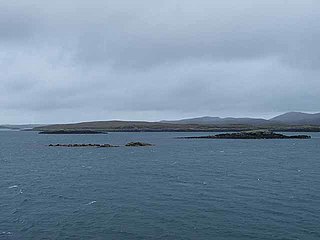
Gighay an uninhabited island off the northeast coast of Barra. It is one of ten islands in the Sound of Barra, a Site of Community Importance for conservation in the Outer Hebrides of Scotland.

There are many small islands in Scotland called Flodday or similar and this list provides a guide to their location. The derivation of the name is from the Old Norse floti meaning "raft" or "float". The similar island names Fladda and Flotta are also from the Norse flatr and mean "flat island". Usage is not always consistent in external sources.

Disambiguation: "Ceann Iar" is a common Scottish placename meaning Western Headland

Stuley is an island lying to the east of South Uist in the Outer Hebrides, Scotland. It lies off the section of coastline between Loch Eynort and Loch Boisdale. It is 45 hectares (0.17 sq mi) and 40 metres (131 ft) at its highest point.

<span class="mw-page-title-main">Fraoch-Eilean</span>

Fraoch-eilean is a small island with an uncertain population north of Benbecula in the Outer Hebrides of Scotland. It is about 55 hectares in extent and the highest point is 11 metres (36 ft). Its name derives from the Gaelic for "heather island".

<span class="mw-page-title-main">Eileanan Chearabhaigh</span> Tidal islands of Scotland

Eileanan Chearabhaigh is a collection of small uninhabited tidal islands off the south east coast of Benbecula in the Outer Hebrides of Scotland. The English language name Keiravagh Islands is sometimes used.

<span class="mw-page-title-main">Ceallasaigh Beag</span> Island in the Outer Hebrides, Scotland

Ceallasaigh Beag is a low-lying island in Loch Maddy off North Uist in the Outer Hebrides of Scotland. This an area of shallow lagoons filled and drained by the tides each day. Ceallasaigh Mòr lies to the south and these two islets are connected by a narrow strip of sand during some low tides.

<span class="mw-page-title-main">Flodday, Loch Maddy</span> Island in the Outer Hebrides, Scotland

Flodday is an uninhabited island in Loch Maddy, North Uist in the Outer Hebrides of Scotland.

<span class="mw-page-title-main">Sound of Barra</span>

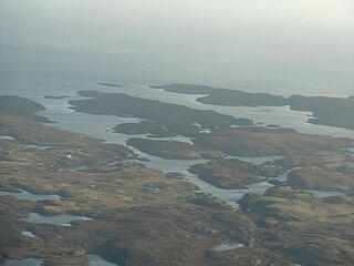
The Sound of Barra is a large ocean inlet or sound situated to the north of the isle of Barra and to the south of South Uist in the Outer Hebrides in Scotland. Since 2014 it has been designated as a Special Area of Conservation (SAC). The Sound of Barra is composed of 98.91% marine and inlet areas, 1.07% mudflats and other semi-submerged areas and 0.02% sea cliffs and islets. There are ten islands in the sound, with only Eriskay still being inhabited:

References

Footnotes

  1. 1 2 Watson (2004) p. 505.
  2. Rick Livingstone’s Tables of the Islands of Scotland (pdf) Argyll Yacht Charters. Retrieved 12 Dec 2011.
  3. 1 2 3 Ordnance Survey. OS Maps Online (Map). 1:25,000. Leisure.
  4. 1 2 "Orosay, Sound of" Gazetteer for Scotland. Retrieved 17 August 2009.
  5. Haswell-Smith, Hamish (2004). The Scottish Islands. Edinburgh: Canongate. p. 221. ISBN   978-1-84195-454-7.
  6. "Cille Bharra". Undiscovered Scotland. Retrieved 18 August 2009.
  7. "Barra Airport". Highlands and Islands Airports Limited. Retrieved 6 April 2009.
  8. Ritchie, W. (1971) Commissioned Report No. 047: The beaches of Barra and the Uists. A survey of the beach, dune and machair areas of Barra, South Uist, Benbecula, North Uist and Berneray. SNH/Countryside Commission for Scotland. Retrieved 17 August 2009. pp 71-72.

57°1′41″N7°25′14″W / 57.02806°N 7.42056°W / 57.02806; -7.42056