Meaning of name | MacNiven's island |
---|---|
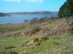
![]() Eilean Mhic Chrion from near Ormaig | |
Location | |
OS grid reference | NM803034 |
Coordinates | 56°10′23″N5°32′24″W / 56.173°N 5.540°W |
Physical geography | |
Island group | Loch Craignish |
Area | 40 ha (99 acres) [1] |
Area rank | 220= [2] |
Highest elevation | 63 m (207 ft) |
Administration | |
Sovereign state | United Kingdom |
Country | Scotland |
Council area | Argyll and Bute |
Demographics | |
Population | 0 |
![]() | |
References | [3] [4] |
Eilean Mhic Chrion is a tidal island sheltering Ardfern in Loch Craignish, Scotland.
Eilean Mhic Chrion is one of 43 tidal islands that can be walked to from the mainland of Great Britain and one of 17 that can be walked to from the Scottish mainland. [5]
![]() | Wikimedia Commons has media related to Eilean Mhic Chrion . |
Coordinates: 56°10′22″N5°32′24″W / 56.17278°N 5.54000°W
![]() | This Argyll and Bute location article is a stub. You can help Wikipedia by expanding it. |
Island Davaar or Davaar Island is located at the mouth of Campbeltown Loch off the east coast of Kintyre, in Argyll and Bute, Scotland. It is a tidal island, linked to the mainland by a natural shingle causeway called the Dhorlin near Campbeltown at low tide. The crossing can be made in around 40 minutes.
Loch Leven is a sea loch located on the west coast of Scotland. It is spelled Loch Lyon in Timothy Pont's map of the area and is pronounced Li' un. The local Gaelic pronunciation is Lee' oon
Erraid is a tidal island approximately 1 mile square located in the Inner Hebrides of Scotland. It lies west of Mull and southeast of Iona. The island receives about 1,000 millimetres (40 in) of rain and 1,350 hours of sunshine annually, making it one of the driest and sunniest places on the western seaboard of Scotland. It is attended by numerous uninhabited small islets, the largest being Eilean Dubh, Eilean nam Muc, Eilean Chalmain, Eilean Ghomain and Eilean na Seamair.
Castle Tioram is a ruined castle that sits on the tidal island Eilean Tioram in Loch Moidart, Lochaber, Highland, Scotland. It is located west of Acharacle, approximately 80 km (50 mi) from Fort William. Though hidden from the sea, the castle controls access to Loch Shiel. It is also known to the locals as "Dorlin Castle". The castle is a scheduled monument.
Rough Island is a 20-acre uninhabited tidal island located in the Rough Firth off the Solway Firth, Scotland, in the historical county of Kirkcudbrightshire the same region where the River Urr flows into the Solway. The isle of Rough is 79 feet at its highest point.
Lunga is one of the Slate Islands in the Firth of Lorn in Argyll and Bute, Scotland. The "Grey Dog" tidal race, which runs in the sea channel to the south, reaches 8 knots (15 km/h) in full flood. The name 'Lunga' is derived from the Old Norse for 'isle of the longships', but almost all other place names are Gaelic in origin. The population was never substantial and today the main activity is an adventure centre on the northern headland of Rubha Fiola. The surrounding seas are fished for prawns and scallops and there is a salmon farm off the south eastern shores. The Special Area of Conservation of which the island is part hosts a growing number of outdoor leisure pursuits.
Eilean Shona is a tidal island in Loch Moidart, Scotland. The modern name may be from the Old Norse for "sea island". The pre-Norse Gaelic name, as recorded by Adomnán was Airthrago or Arthràigh, meaning 'foreshore island', similar to the derivation of Erraid.
Island Macaskin or MacAskin is an island in Loch Craignish, in the Inner Hebrides of Scotland.
Oldany Island is an uninhabited island in Assynt, Sutherland, north-west Scotland.
Na h-Eileanan Iasgaich comprise a small uninhabited archipelago in Loch Boisdale, in the south east of the island of South Uist, in the Outer Hebrides, Scotland. The individual islands are separated from one another at high tide, but connected to one another at low tide,. They are around 50 ha in extent and over 20m at their highest point. Their boundaries are ill-defined.
Bernera Island or simply Bernera is a tidal island off Lismore, in Argyll, Scotland.
Loch Craignish is a sea loch on the mid-Argyll coast.
Eilean Ighe is a small tidal island near Arisaig in the Inner Hebrides of Scotland.
Eilean Tigh is a tidal island in the Sound of Raasay of Scotland, that lies between Rona and Raasay.
The Sound of Islay is a narrow strait between the islands of Islay and Jura off the west coast of Scotland. It is about 30 kilometres in extent from north to south and lies between Rubh' a' Mhàil on Islay and Rubh' Aird na Sgitheich on Jura to the north and Macarthur's Head and Rubha na Tràille to the south. The islands in the Sound are Am Fraoch Eilean, Brosdale Island and Glas Eilean, all of which are off the south east coast of Jura. These islands, Jura south of Loch Tarbert and the eastern part of the Sound are one of 40 National Scenic Areas in Scotland.
Loch Sween is a sea loch located near Lochgilphead, Argyll and Bute, Scotland. Castle Sween is located on the southern shore towards the seaward end of the loch. The village of Tayvallich, a favoured haven for water craft as it sits at the head of sheltered Loch a' Bhealaich, lies on the northern shore.
Eilean dà Mhèinn, is a small inhabited island in Loch Crinan and one of the Inner Hebrides of Scotland.