Belnahua

Last updated

Belnahua
Scottish Gaelic nameBeul na h-Uamha
Meaning of nameThe mouth of the cave
Belnahua.jpg
Belnahua from the south
Location
Argyll and Bute UK relief location map.jpg
Red pog.svg
Belnahua
Belnahua shown within Argyll and Bute
OS grid reference NM713127
Coordinates 56°15′N5°41′W / 56.25°N 5.69°W / 56.25; -5.69
Physical geography
Island group Slate Islands
Highest elevation22 m (72 ft)
Administration
Sovereign state United Kingdom
Country Scotland
Council area Argyll and Bute
Demographics
Population0
Lymphad3.svg
References [1] [2] [3] [4]

Belnahua is one of the Slate Islands, in the Firth of Lorn in Scotland, known for its deserted slate quarries. The bedrock that underpins its human history is part of the Scarba Conglomerate Formation and its value has been on record since the 16th century. [5] [6] Likely uninhabited before commercial quarrying commenced, [7] under the control of the Stevenson family during the 19th century [8] the population expanded to over 150 [9] before the island was abandoned again in 1914. [10]

Contents

Living on a remote island in the 19th century came with significant hardships and the lives of the quarry workers have been described in unflattering terms by modern commentators, one describing them as in effect "slaves". [11] Today, the ruined buildings and abandoned machinery lie amidst the water filled quarries and are home only to wildlife. [12] There are very strong tidal streams in the area and this a potentially hazardous location for shipping. In 1936 the cargo vessel Helēna Faulbaums was wrecked on the island, with the loss of 15 lives. [13]

Geography

Belnahua is in the council area of Argyll and Bute and lies two kilometres (1+14 miles) west of Luing and three kilometres (two miles) east of Dùn Chonnuill in the Garvellachs. [3] The island is roughly 6 hectares (15 acres) in extent. [14] About 500 metres (550 yards) southeast is the islet of Fladda, [3] the lighthouse on which is a "well-known sea-mark in the Sound of Luing". [2]

The island has been considerably denuded by quarrying – a process sometimes described as having broken its back. [15] Deep water-filled cuttings and the ruined slate workers cottages remain as a testament to this industry. [16] There was a jetty to the east of the island, [3] [17] but it was worn away within the last quarter of the twentieth century.

Belnahua exists amongst sea lanes that have numerous islands and skerries that "swarm like bees on a branch" amongst the "most treacherous seas and complicated channels of the west coast" of Scotland, [15] including the Gulf of Corryvreckan some ten kilometres (six miles) to the south. [3] The island is part of the Scarba, Lunga and the Garvellachs National Scenic Area. [18]

Geology

The bedrock of Belnahua is in large part a Neoproterozoic age slate, graphitic pelite referred to the Jura Slate Member of the Scarba Conglomerate Formation. The Jura Slates are also found along the east coasts of Scarba and of Jura to the south. Like the Easdale Slates found across the Sound of Luing these slates belong to the Easdale Subgroup of the Dalradian Argyll Group. Three NNW-SSE aligned tracts of metalimestone, assigned to the Ardrishaig Phyllite Formation, are identified in the southern half of Belnahua. A doleritic igneous dyke cuts through the centre of the island and is identified as part of the Mull Dyke Swarm of early Palaeogene age, associated with the central volcanic complex which developed in Mull. In common with other shoreline zones in the region, the relatively flat surface of the island is as a result of marine planation when relative sea levels were higher, the steep sides of the knoll in the west having formed as sea cliffs. [19] [5]

History

Early times

In the 7th century the Cenél Loairn kindred controlled what is today known as Lorn in the kingdom of Dalriada. [20] From about the mid-9th century Belnahua would then have become part of the Norse Kingdom of the Isles. [21] The first written reference to the island appears in the 1549 Description of the Western Isles of Scotland by Donald Monro. [6] He wrote of "Belnachua" or "Belnachna"; "Narrest the Wolfiis iyle layes ane iyllane, callit in Erische Leid-Ellan-Belnachna, quharin ther is fair skailzie aneuche". [6] In modern English this brief entry reads as "Nearest the Wolf's Iyle lies an island called in the Scottish Gaelic language "Ellan-Belnachna", where there is good sufficiency of slate". Not all of the islands that Monro mentions have been identified and the location of "Wolf's Iyle" or "Ellan Madie" is uncertain. [Note 1]

Slate quarrying

Ruined cottages on Belnahua Belnahua Ruins.jpg
Ruined cottages on Belnahua

According to the Old Statistical Account , quarrying began on Belnahua in 1632. [8] The island was probably uninhabited prior to that. [7] [Note 2] By this time the island may have become part of the Netherlorn estates of the Breadalbane family (a branch of Clan Campbell). [24] In 1730 Colin Campbell of Carwhin was appointed to oversee their estates in Netherlorn and was tasked with exploiting the area's natural resources. Easdale slate had been used from as early as the 12th century using seasonal labour from the Ardmaddy estate. [7] In 1745 Campbell created the Easdale Marble and Slate Company (later shortened to Easdale Slate Company) in order to place extractions from the area on a more commercial basis. [25] At that point Easdale was producing 1 million slates per annum and as further quarries were opened this further increased the company's production to 5 million per annum by 1800. [26]

In the 1790s Belnahua was leased out by the landowners to the Stevenson brothers whose aim was to supply slate for the developing town of Oban. [Note 3] Cottages were constructed for the workers in the south east corner of the island and there was a school and company store. Virtually all the provisions had to be supplied from Luing, including drinking water. Rainwater was collected in reservoirs but it was used to power the steam engines that drove the quarries' pumps. By the early 19th century the Stevenson family were shipping slate from both Belnahua and Fladda to Campbeltown in Kintyre. [8] Their lease was eventually passed on to the Shaw family of Luing who hired a quarry master that lived on a 2-storey house on the island. At the height of the activity there were 30 quarry workers and their families living there and a total population of over 150. [27] [9] With the commencement of World War I in 1914 quarry work ceased and the island was completely abandoned and it has been uninhabited ever since. [10]

The Breadalbane estates were sold off in the 1930s [10] and as of 2004 Belnahua was owned by the Carling family. [2]

Life on the island

Living on a remote island in the 19th century came with hardships. Quarry workers sought employment from around Scotland, some arriving in an area where they would have had few friends or family to support them in times of difficulty. There is no protection from the wind and it can be a "harsh and desolate" location, especially in winter. [9] One writer has gone so far as to suggest that although some islands can suggest a lifestyle of peace and tranquility, that Belnahua "buffeted by the sea and the winds, overshadowed from the south by the lowering cliffs of Scarba, and dominated by the threatening deep maws of the slate quarries at its heart, could surely have engendered little more than tension, fear, agitation and anxiety." [8]

Paul Murton took a similar view of the islanders' circumstances: "They were paid poorly and forced to rent their homes and buy all their supplies from their feudal superior, the Campbell Marquis of Breadalbane, who kept the workforce in a state of permanent debt and poverty. Effectively, the people of Belnahua were slaves." [11]

Shipwrecks

Belnahua and Fladda from Cullipool on Luing with the Garvellachs in the distance. Cullipool from the east - geograph.org.uk - 168978.jpg
Belnahua and Fladda from Cullipool on Luing with the Garvellachs in the distance.

On 15 August 1900 the 310-tonne (340-short-ton) iron steamship Apollo ran aground on Bono Reef two kilometres (1+14 mi) north of Belnahua. She was carrying a cargo of granite cobble stones from Aberdeen to Newport. The wreck lies in a gully some 10 metres (35 ft) down amidst thick kelp. [13]

The 1,770-tonne (1,950-short-ton) unladen Latvian vessel Helēna Faulbaums left the Mersey on 26 October 1936 en route for Blyth. Encountering a storm, she headed for the Firth of Lorn seeking shelter although the light load meant that the propeller was ineffective in the high seas. At 7pm her steering failed and captain ordered the anchors to be deployed but they could not hold in the deep waters. [28] The radio operator sent out SOS messages but the storm had disrupted communications and the local coastguards could not make contact with the lifeboat station at Port Askaig. The lifeboat was finally launched when a message was broadcast by the BBC. [29] There is an extensive drying reef to the north of Belnahua [3] and at 10pm that night the Helēna Faulbaums struck it broadside and foundered, sinking within ten minutes [28] with the loss of 15 lives including two 18-year-old boys. [Note 4] Four sailors managed to scramble ashore and were rescued the next day by the Islay lifeboat and taken to Crinan. [30] The bodies of the other crew members were washed ashore on Luing. [29] [31] Seven of the perished were later buried in a widely attended ceremony in Cullipool cemetery on Luing, but the captain of the ship Nikolajs Cughauss was repatriated to Latvia by the wish of his brother. A small monument has also been built at the gravesite. [31] [32] [Note 5]

The wreck lies in 60 metres (195 ft) of water. There are very strong tidal streams in the area and diving is only possible at slack water. [13]

Wildlife

Otters and seals are regular visitors to the coast of Belnahua, the latter fishing for ling, saithe and cod which get trapped in the sea-flooded quarries at low tide. The only land mammal on the island is the field vole. [33]

The soils are very poor in quality so horticultural options are "limited or non-existent" and the ruined buildings and abandoned machinery lie amidst "waist high grasses". [12] The aim of the Slate Islands Heritage Trust is to record the island's history but otherwise leave it untouched. [34]

Notes

  1. R. W. Munro offers no suggestion for this island's identity. [22] A derivation of Ulva is from the Old Norse ulvøy meaning "wolf island". [23] The tidal Ulva Islands in Loch Sween at NR727824 are thus a possibility for "the Wolfiis iyle" although they are by no means "nearest" to Belnahua.
  2. Withall states that Belnahua was "probably uninhabited" prior to the formation of the Easdale Marble and Slate Company in 1730, [7] but Pallister quotes the significantly earlier date of 1632. [8]
  3. Pallister states that as Belnahua was part of the parish of Jura rather than Kilbrandon and Kilchattan that it never became part of the Breadalbane estates and implies that the Stevensons had set up an independent commercial "empire". [8]
  4. Haswell-Smith has the loss of life at 16. [2]
  5. See Talk:Belnahua#Latvian sources and the Helēna Faulbaums for a translation of this article from Brīvā Zeme into English.

Related Research Articles

Lismore is an island of some 2,351 hectares in the Inner Hebrides of Scotland. The climate is damp and mild, with over 166 centimetres (65 in) of rain recorded annually. This fertile, low-lying island was once a major centre of Celtic Christianity, with a 6th-century monastery associated with Saint Moluag, and later became the seat of the medieval Bishop of Argyll. There are numerous ruined structures including a broch and two 13th-century castles.

<span class="mw-page-title-main">Slate Islands</span>

The Slate Islands are an island group in the Inner Hebrides, lying immediately off the west coast of Scotland, north of Jura and southwest of Oban. The main islands are Seil, Easdale, Luing, Shuna, Torsa and Belnahua. Scarba and Kerrera, which lie nearby are not usually included.

<span class="mw-page-title-main">Seil</span>

Seil is one of the Slate Islands, located on the east side of the Firth of Lorn, 7 miles southwest of Oban, in Scotland. Seil has been linked to the mainland by bridge since the late 18th century.

Easdale is one of the Slate Islands, in the Firth of Lorn, Scotland. Once the centre of the Scottish slate industry, there has been some recent island regeneration by the owners. This is the smallest of the Inner Hebrides' inhabited islands and is "home to traditional white-washed cottages, a small pub and disused slate quarries". One of the latter, filled with water, is used for swimming.

<span class="mw-page-title-main">Luing</span>

Luing is one of the Slate Islands, Firth of Lorn, in the west of Argyll in Scotland, about 16 miles (26 km) south of Oban. The island has an area of 1,430 hectares and is bounded by several small skerries and islets. It has a population of around 200 people, mostly living in Cullipool, Toberonochy, and Blackmillbay.

<span class="mw-page-title-main">Scarba</span>

Scarba is an island, in Argyll and Bute, Scotland, just north of the much larger island of Jura. The island has not been permanently inhabited since the 1960s. Until his death in 2013 it was owned by Richard Hill, 7th Baron Sandys; its owner now is Shane Cadzow who farms Luing cattle on the nearby island of Luing and grazes some of the cattle on Scarba. Kilmory Lodge is used seasonally as a shooting lodge, the island having a flourishing herd of red deer.

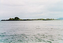
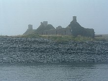
Torsa is one of the Slate Islands in Argyll and Bute, Scotland. Lying east of Luing and south of Seil, this tidal island was inhabited until the 1960s. There is now only one house there, which is used for holiday lets. The underlying bedrock is slate but unlike Torsa's immediate island neighbours this has never been worked commercially. The island's name is of Norse origin but the most prominent historical structure on the island is the ruined Caisteal nan Con on the northeast shore, once held by Clan Campbell. The abundant sea life in the waters surrounding the island are protected by the Loch Sunart to the Sound of Jura Marine Protected Area.

<span class="mw-page-title-main">Firth of Lorn</span> Body of water

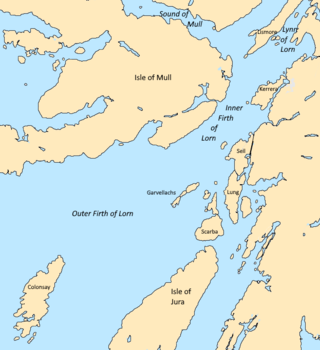
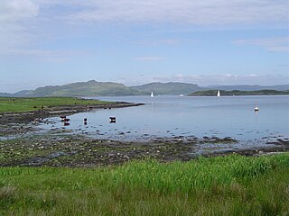
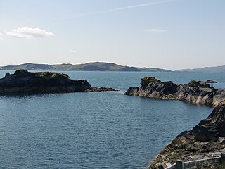
The Firth of Lorn or Lorne is the inlet of the sea between the south-east coast of the Isle of Mull and the mainland of Scotland. It includes a number of islands, and is noted for the variety of wildlife habitats that are found. In 2005, a large part of the Firth became a Special Area of Conservation.

Lunga is one of the Slate Islands in the Firth of Lorn in Argyll and Bute, Scotland. The "Grey Dog" tidal race, which runs in the sea channel to the south, reaches 8 knots (15 km/h) in full flood. The name "Lunga" is derived from the Old Norse for "isle of the longships', but almost all other place names are Gaelic in origin. The population was never substantial and today the main activity is an adventure centre on the northern headland of Rubha Fiola. The surrounding seas are fished for prawns and scallops and there is a salmon farm off the south eastern shores. The Special Area of Conservation of which the island is part hosts a growing number of outdoor leisure pursuits.

<span class="mw-page-title-main">Nave Island</span>

Nave Island lies to the north of Islay in the Inner Hebrides near the mouth of Loch Gruinart. It is uninhabited.

<span class="mw-page-title-main">Insh Island</span>

Insh Island or simply Insh is an uninhabited island west of the island of Seil in the Firth of Lorn, Scotland.

<span class="mw-page-title-main">Sound of Islay</span>

The Sound of Islay is a narrow strait between the islands of Islay and Jura off the west coast of Scotland. It is about 30 kilometres in extent from north to south and lies between Rubh' a' Mhàil on Islay and Rubh' Aird na Sgitheich on Jura to the north and Macarthur's Head and Rubha na Tràille to the south. The islands in the Sound are Am Fraoch Eilean, Brosdale Island and Glas Eilean, all of which are off the south east coast of Jura. These islands, Jura south of Loch Tarbert and the eastern part of the Sound are one of 40 National Scenic Areas in Scotland.

<span class="mw-page-title-main">Ellenabeich</span> Human settlement in Scotland

Ellenabeich is a small village on the isle of Seil – an island on the east side of the Firth of Lorn, 7 miles (11 km) southwest of Oban, in Scotland. It is a former slate-mining village and is where parts of Ring of Bright Water were filmed. Seil is one of the Slate Islands.

<span class="mw-page-title-main">Eilean-a-beithich</span>

Eilean-a-beithich or Eilean nam Beitheach was once one of the Slate Islands, located in Easdale Sound between Easdale and Seil, in the Inner Hebrides.

<i>Description of the Western Isles of Scotland</i> 16th-century Scottish manuscript

Description of the Western Isles of Scotland is the oldest known account of the Hebrides and the Islands of the Clyde, two chains of islands off the west coast of Scotland. The author was Donald Monro, a clergyman who used the title of "Dean of the Isles" and who lived through the Scottish Reformation. Monro wrote the original manuscript in 1549, although it was not published in any form until 1582 and was not widely available to the public in its original form until 1774. A more complete version, based on a late 17th-century manuscript written by Sir Robert Sibbald, was first published as late as 1961. Monro wrote in Scots and some of the descriptions are difficult for modern readers to render into English. Although Monro was criticised for publishing folklore and for omitting detail about the affairs of the churches in his diocese, Monro's Description is a valuable historical account and has reappeared in part or in whole in numerous publications, remaining one of the most widely quoted publications about the western islands of Scotland.

<span class="mw-page-title-main">Scarba, Lunga and the Garvellachs National Scenic Area</span>

Scarba, Lunga and the Garvellachs is the name of one of the 40 national scenic areas of Scotland. The designated area covers the islands of Scarba, Lunga, and the Garvellachs, all of which lie in the Firth of Lorn, along with much of the surrounding seascape. The national scenic areas are defined so as to identify areas of exceptional scenery and to ensure its protection by restricting certain forms of development, and are considered to represent the type of scenic beauty "popularly associated with Scotland and for which it is renowned". The Scarba, Lunga and the Garvellachs NSA covers 6,542 ha in total, consisting of 2,139 ha of land with a further 4,402 ha being marine.

<span class="mw-page-title-main">Brosdale Island</span>

Brosdale Island is an uninhabited island in the council area of Argyll and Bute, Scotland. It is 1.25 miles from Jura House on Jura. It is about 1/4 of a mile long and 1/4 of a mile wide.

References

Footnotes

  1. 2001 UK Census per List of islands of Scotland
  2. 1 2 3 4 Haswell-Smith (2004), p. 67.
  3. 1 2 3 4 5 6 Ordnance Survey. OS Maps Online (Map). 1:25,000. Leisure.
  4. Iain Mac an Tailleir. "Placenames" (PDF). Pàrlamaid na h-Alba. Archived from the original (PDF) on 23 September 2011. Retrieved 28 July 2007.
  5. 1 2 "Kilmartin, Scotland sheet 36, Bedrock and Superficial deposits". BGS large map images. British Geological Survey. Retrieved 5 February 2020.
  6. 1 2 3 Monro (1549), 27.
  7. 1 2 3 4 Withall (2013), p. 5.
  8. 1 2 3 4 5 6 Pallister (2007), Slated.
  9. 1 2 3 Withall (2018), Early Days in the Easdale Practice.
  10. 1 2 3 Withall (2013), p. 11.
  11. 1 2 Murton (2017), p. 32.
  12. 1 2 Withall (2013), pp. 50, 69.
  13. 1 2 3 Baird (1995), p. 115.
  14. Estimate from Ordnance Survey maps.
  15. 1 2 Murray (1977), p. 124.
  16. "Overview of Belnahua". Gazetteer for Scotland. Retrieved 28 July 2007.
  17. "Belnahua slate quarries". Canmore. Retrieved 7 June 2020
  18. "National Scenic Areas of Scotland: overview map". (pdf) Scottish Government. Retrieved 26 June 2020.
  19. "Onshore Geoindex". British Geological Survey. British Geological Survey. Retrieved 10 June 2020.
  20. Fraser (2009), pp. 245–46.
  21. Woolf (2007), pp. 99–100, 286–89.
  22. Munro (1961), p. 116.
  23. Haswell-Smith (2004), p. 102.
  24. Withall (2013), p. viii.
  25. Withall (2013), p. 6.
  26. Withall (2013), p. 7.
  27. "Belnahua". Slate Islands Heritage Trust. Retrieved 7 June 2020
  28. 1 2 Baird (1995), p. 113.
  29. 1 2 Baird (1995), p. 114.
  30. "Helena Faulbaums: Belnahua, Sound Of Luing". Canmore - Quoting the Oban Times of 31 October 1936. Retrieved 7 June 2020
  31. 1 2 "Luing recalls tragedy that claimed sailors". The Oban Times. 10 November 2016. Retrieved 15 May 2020 via PressReader.
  32. "Šodien gulda Skotijas zemē 7 latvju jūrniekus" [Today 7 Latvian sailors are buried on Scottish soil]. Brīvā Zeme . 2 November 1936. Archived from the original on 8 January 2021. Retrieved 6 June 2020.
  33. Withall (2013), p. 50.
  34. Withall (2013), p. 69.

Bibliography

Coordinates: 56°15′N5°41.3′W / 56.250°N 5.6883°W / 56.250; -5.6883