
Ross and Cromarty, sometimes referred to as Ross-shire and Cromartyshire, is a variously defined area in the Highlands and Islands of Scotland. There is a registration county and a lieutenancy area in current use, the latter of which is 8,019 square kilometres in extent. Historically there has also been a constituency of the Parliament of the United Kingdom, a local government county, a district of the Highland local government region and a management area of the Highland Council. The local government county is now divided between two local government areas: the Highland area and Na h-Eileanan Siar. Ross and Cromarty border Sutherland to the north and Inverness-shire to the south.

The Treshnish Isles are an archipelago of small islands and skerries, lying west of the Isle of Mull, in Scotland. They are part of the Inner Hebrides. Trips to the Treshnish Isles operate from Ulva Ferry, Tobermory Ardnamurchan and Tiree

The Summer Isles are an archipelago lying in the mouth of Loch Broom, in the Highland region of Scotland.
Eilean Dubh Mòr is an uninhabited island in the Inner Hebrides of Scotland. It lies at the mouth of the Firth of Lorn, between the islands of Lunga and Garbh Eileach. The area of the island has been measured variously—at 50 hectares by Livingstone and 65 hectares by Haswell-Smith, the latter including the nearby islet of Eilean Dubh Beag, which is joined to Eilean Dubh Mòr at low tide.
Sgat Mòr and Sgat Beag are two small islands that lie at the mouth of Loch Fyne by the shore of the Cowal peninsula on the west coast of Scotland.
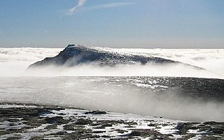
Aonach Beag is a mountain in the Scottish Highlands. It is located about 3 km east of Ben Nevis on the north side of Glen Nevis, near the town of Fort William. Apart from Ben Nevis, Aonach Beag is the highest peak in the British Isles outwith the Cairngorm mountains of eastern Scotland.

Ross-shire is a historic county in the Scottish Highlands. The county borders Sutherland to the north and Inverness-shire to the south, as well as having a complex border with Cromartyshire – a county consisting of numerous enclaves or exclaves scattered throughout Ross-shire's territory. Ross-shire includes most of Ross along with Lewis in the Outer Hebrides. Dingwall is the traditional county town. The area of Ross-shire is based on that of the historic province of Ross, but with the exclusion of the many enclaves that form Cromartyshire.
The island of Lunga is the largest of the Treshnish Isles in Argyll and Bute, Scotland. The Isles are part of the Loch Na Keal National Scenic Area.
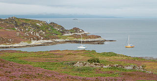
Lunga is one of the Slate Islands in the Firth of Lorn in Argyll and Bute, Scotland. The "Grey Dog" tidal race, which runs in the sea channel to the south, reaches 8 knots (15 km/h) in full flood. The name 'Lunga' is derived from the Old Norse for 'isle of the longships', but almost all other place names are Gaelic in origin. The population was never substantial and today the main activity is an adventure centre on the northern headland of Rubha Fiola. The surrounding seas are fished for prawns and scallops and there is a salmon farm off the south eastern shores. The Special Area of Conservation of which the island is part hosts a growing number of outdoor leisure pursuits.

Bac Mòr is a Scottish island, one of the Treshnish Isles, sometimes referred to as The Dutchman's Cap in English because of its shape.
Cairn na Burgh Mòr is one of the Treshnish Isles in the Inner Hebrides of Scotland.
Fladda is the northernmost of the Treshnish Isles. Its name comes from the Old Norse Flat-ey meaning "flat island". Fladda is owned by the Hebridean Trust.
There are many small islands in Scotland called Flodday or similar and this list provides a guide to their location. The derivation of the name is from the Old Norse floti meaning 'raft' or 'float'. The similar island names Fladda and Flotta are also from the Norse flatr and mean 'flat island'. Usage is not always consistent in external sources.
Soay Beag is a small, uninhabited tidal island in West Loch Tarbert, between the northern and southern parts of Harris. Soay Beag is separated from the southwest coast of North Harris by the Soay Sound. The island is located immediately to the northwest of the larger Soay Mòr, which is accessible on foot at low tide. Soay Beag's highest elevation is 37m.
Cairn na Burgh Beag is one of the Treshnish Isles in the Inner Hebrides, Scotland.

Pabay Mòr or Pabaigh Mòr is an uninhabited island in the Outer Hebrides of Scotland.
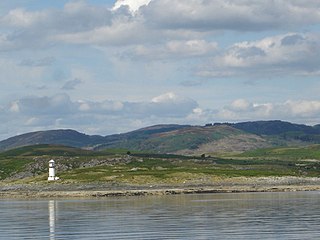
Cairnburgh Castle is a ruined castle that is located on the islands of Cairn na Burgh Mòr and Cairn na Burgh Beag, Argyll and Bute, Scotland. These islands are at the northern extremity of the Treshnish Isles at the mouth of Loch Tuath, Mull north of Iona. 1991's The Changing Scottish Landscape characterizes it as "one of the most isolated fortifications in Britain...[and] also one of the strangest."
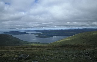
Loch na Keal, meaning Loch of the Kyle, or Narrows, also Loch of the Cliffs, is the principal sea loch on the western, or Atlantic coastline of the island of Mull, in the Inner Hebrides, Argyll and Bute, Scotland. Loch na Keal extends over 20 kilometres (12 mi) inland, almost bisecting Mull, and extending to within 5 km (3 mi) of the eastern shore. The loch gives its name to the Loch na Keal National Scenic Area, one of forty national scenic areas in Scotland.


