Sanday, Inner Hebrides

Last updated

Sanday
Scottish Gaelic nameSandaigh
Scots nameSandee [1]
Location
Lochaber UK relief location map.jpg
Red pog.svg
Sanday
Sanday shown within Lochaber
OS grid reference NG282043
Coordinates 57°03′N6°29′W / 57.05°N 6.49°W / 57.05; -6.49
Physical geography
Island group Small Isles
Area184 ha (0.71 sq mi)
Area rank114 [2]
Highest elevation59 m (194 ft)
Administration
Sovereign state United Kingdom
Country Scotland
Council area Highland
Demographics
Population9 [3]
Population rank69 [2]
Population density5 people/km2 [3] [4]
Lymphad3.svg
References [4] [5]

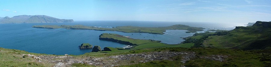
Sanday (Scottish Gaelic : Sandaigh; Scots : Sandee) is one of the Small Isles, in the Scottish Inner Hebrides. It is a tidal island linked to its larger neighbour, Canna, via sandbanks at low tide, and also connected to the larger island by a bridge. Canna and Sanday form a single community, and are usually described as Canna.

Contents

The school Sanday school.jpg
The school

Like its neighbour, Canna, the whole island is owned by the National Trust for Scotland (NTS), and is part of the Lochaber committee area of Highland Council. [6] Whereas Canna is run by the NTS as a single farm, parts of Sanday are used for crofting.

A small primary school on Sanday served the communities of both islands, although is currently closed. [7] A footbridge to the island was built in 1905 to allow pupils from Canna to reach the school regardless of the state of the tide. This bridge was destroyed by storms in 2005, and has been replaced by a road bridge which was completed in April 2006. This new bridge allows vehicular access at all tide levels between the two islands, although parts of the road on Sanday were still covered by water during high tides until the completion of a new road in 2018. [7]

From the mainland the island can be reached by the Caledonian MacBrayne ferry system from the port of Mallaig. Sanday includes rocks that are geologically part of the Paleocene and Eocene British Tertiary Volcanic Province, among some of the youngest rocks found in Scotland. [8]

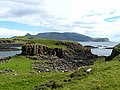
The largest and most conspicuous building on Sanday is the deconsecrated Catholic church of St Edward, which stands alone on an elevated part of the island, away from the cottages which, together with the school, cluster around the bay facing Canna.

The church, which is also owned by the National Trust for Scotland, was restored and converted into a hostel and Study Centre by the Hebridean Trust. This project was undertaken at the invitation of the owners. The centre is linked to the Archive of Gaelic language and culture that was created by the former owner of Canna and Sanday, John Lorne Campbell. It was successfully completed and opened in 2001 by the Princess Royal. Subsequently, there was water ingress, which caused damage to the interior. This challenge is in the hands of the National Trust for Scotland.

The island is home to a number of different types of wildlife, including puffins, great skua and Manx shearwater. [9]

Isle of Canna Panorama 2.jpg
Panorama taken from Compass Hill on Canna, overlooking Canna Bay and Sanday, the island of Rùm in the distance.

See also

Related Research Articles

<span class="mw-page-title-main">Small Isles</span> Island group off the west coast of Scotland

The Small Isles are a small archipelago of islands in the Inner Hebrides, off the west coast of Scotland. They lie south of Skye and north of Mull and Ardnamurchan – the most westerly point of mainland Scotland.

<span class="mw-page-title-main">Canna, Scotland</span> Island in the Inner Hebrides

Canna is the westernmost of the Small Isles archipelago, in the Scottish Inner Hebrides. It is linked to the neighbouring island of Sanday by a road and sandbanks at low tide. The island is 4.3 miles (6.9 km) long and 1 mile (1.6 km) wide. The isolated skerries of Hyskeir and Humla lie 6.2 miles (10.0 km) south-west of the island.

<span class="mw-page-title-main">Sanday, Orkney</span> Island in Orkney, Scotland

Sanday is one of the inhabited islands of Orkney that lies off the north coast of mainland Scotland. With an area of 50.43 km2 (19.5 sq mi), it is the third largest of the Orkney Islands. The main centres of population are Lady Village and Kettletoft. Sanday can be reached by Orkney Ferries or by plane from Kirkwall on the Orkney Mainland. On Sanday, an on-demand public minibus service allows connecting to the ferry.

<span class="mw-page-title-main">Slate Islands</span>

The Slate Islands are an island group in the Inner Hebrides, lying immediately off the west coast of Scotland, north of Jura and southwest of Oban. The main islands are Seil, Easdale, Luing, Shuna, Torsa and Belnahua. Scarba and Kerrera, which lie nearby are not usually included.

Scalpay is an island in the Outer Hebrides of Scotland.

Berneray is an island and community in the Sound of Harris, Scotland. It is one of fifteen inhabited islands in the Outer Hebrides. It is famed for its rich and colourful history which has attracted much tourism. It lies within the South Lewis, Harris and North Uist National Scenic Area, one of 40 such areas in Scotland which are defined so as to identify areas of exceptional scenery and to ensure its protection from inappropriate development.

Easdale is one of the Slate Islands, in the Firth of Lorn, Scotland. Once the centre of the Scottish slate industry, there has been some recent island regeneration by the owners. This is the smallest of the Inner Hebrides' inhabited islands and is "home to traditional white-washed cottages, a small pub and disused slate quarries". One of the latter, filled with water, is used for swimming.

<span class="mw-page-title-main">Luing</span>

Luing is one of the Slate Islands, Firth of Lorn, in the west of Argyll in Scotland, about 16 miles (26 km) south of Oban. The island has an area of 1,430 hectares and is bounded by several small skerries and islets. It has a population of around 200 people, mostly living in Cullipool, Toberonochy, and Blackmillbay.

<span class="mw-page-title-main">Ben Lawers</span> 1214m high mountain in Scotland

Ben Lawers is the highest mountain in the Breadalbane region of the Scottish Highlands. It lies north of Loch Tay and is the highest peak of the 'Ben Lawers group', a ridge that includes six other Munros: Beinn Ghlas, Meall Garbh, Meall Corranaich, An Stùc, Meall Greigh and Meall a' Choire Leith. It is also the highest peak in Perthshire, and the tenth highest Munro in Scotland. Ben Lawers was long thought to be over 4,000 feet in height; accurate measurement in the 1870s showed it to be 3,983 feet (1,214 m).

<span class="mw-page-title-main">Dornoch Firth</span> Scottish firth

The Dornoch Firth is a firth on the east coast of Highland, in northern Scotland. It forms part of the boundary between Ross and Cromarty, to the south, and Sutherland, to the north. The firth is designated as a national scenic area, one of 40 such areas in Scotland. The national scenic area covers 15,782 ha in total, of which 4,240 ha is the marine area of the firth below low tide. A review of the national scenic areas by Scottish Natural Heritage in 2010 commented:

By comparison with other east coast firths the Dornoch Firth is narrow and sinuous, yet it exhibits within its compass a surprising variety of landscapes. It is enclosed by abrupt rounded granitic hills clad in heather moor and scree, their Gaelic names of cnoc, meall and creag giving the clue to their character. Their lower slopes are frequently wooded, oakwoods being a noticeable feature of the area, but with other deciduous and coniferous species represented in plantations which vary from the policy plantings of Skibo Castle to the pines of the Struie Forest.

<span class="mw-page-title-main">Corrieshalloch Gorge</span> Gorge in the Scottish Highlands

Corrieshalloch Gorge is a gorge situated about 20 km south of Ullapool, close to the junction of the A832 and A835 roads near Braemore in the Scottish Highlands. The gorge is approximately 1.5 km long, 60 m deep, and 10 m wide at its lip. The Abhainn Droma flows through Corrieshalloch, below which the landscape opens out into a broad, flat-bottomed glacial trough at the head of Loch Broom.

<span class="mw-page-title-main">Kintail</span>

Kintail is a mountainous area sitting at the head of Loch Duich in the Northwest Highlands of Scotland, located in the Highland Council area.

Na h-Eileanan Iasgaich comprise a small uninhabited archipelago in Loch Boisdale, in the south east of the island of South Uist, in the Outer Hebrides, Scotland. The individual islands are separated from one another at high tide, but connected to one another at low tide,. They are around 50 ha in extent and over 20m at their highest point. Their boundaries are ill-defined.

<span class="mw-page-title-main">Fraoch-Eilean</span>

Fraoch-eilean is a small island with an uncertain population north of Benbecula in the Outer Hebrides of Scotland. It is about 55 hectares in extent and the highest point is 11 metres (36 ft). Its name derives from the Gaelic for "heather island".

<span class="mw-page-title-main">Loch na Keal</span> Sea loch in Argyll and Bute, Scotland

Loch na Keal, meaning Loch of the Kyle, or Narrows, also Loch of the Cliffs, is the principal sea loch on the western, or Atlantic coastline of the island of Mull, in the Inner Hebrides, Argyll and Bute, Scotland. Loch na Keal extends over 20 kilometres (12 mi) inland, almost bisecting Mull, and extending to within 5 km (3 mi) of the eastern shore. The loch gives its name to the Loch na Keal National Scenic Area, one of forty national scenic areas in Scotland.

References

  1. "Map of Scotland in Scots - Guide and gazetteer" (PDF).
  2. 1 2 Area and population ranks: there are c.300 islands over 20ha in extent and 93 permanently inhabited islands were listed in the 2011 census.
  3. 1 2 National Records of Scotland (15 August 2013). "Appendix 2: Population and households on Scotland's Inhabited Islands" (PDF). Statistical Bulletin: 2011 Census: First Results on Population and Household Estimates for Scotland Release 1C (Part Two) (PDF) (Report). SG/2013/126. Retrieved 14 August 2020.
  4. 1 2 Haswell-Smith, Hamish (2004). The Scottish Islands. Edinburgh: Canongate. ISBN   978-1-84195-454-7.
  5. Ordnance Survey: Landranger map sheet 39 Rùm, Eigg, Muck & Canna (Map). Ordnance Survey. 2007. ISBN   9780319229941.
  6. Patterson, A (June 2000). "Seabird Enhancement Programme on the Islands of Canna and Sanday". Case Studies -- Species Regeneration. National Trust for Scotland. Archived from the original on 9 May 2006. Retrieved 10 June 2006.
  7. 1 2 "First road built on tiny island of Sanday". BBC Scotland. 11 June 2018. Retrieved 11 June 2018.
  8. "Tertiary Igneous (TER-IGN)". Geological Conservation Review GCR Database. Joint Nature Conservation Committee. Archived from the original on 28 September 2007. Retrieved 10 June 2006.
  9. Scotland, National Trust for (20 February 2019). "3 key projects". National Trust for Scotland. Archived from the original on 13 July 2019. Retrieved 20 February 2019.