The island rises to a height of 93 metres (305 feet) at Beinn Orasaigh and is linked to Colonsay by a tidal causeway called An Tràigh (The Strand) consisting of sands and mud flats. In the 2001 census Oronsay was recorded as having a population of five people, who lived at the farm adjacent to Oronsay Priory. In 2011 the population had risen to eight.[5] The island has no facilities for visitors and is now privately owned, with the RSPB farming the island for the American owner.[8] It is dependent upon tidal access to and from Colonsay. There is a small grass air strip south of the priory that "fights a losing battle with the rabbits".[3]
Etymology
There are two theories for the origin of the name from Old Norse. Either it is Oran's Isle, St Oran being imagined as the founder of the island's original monastery in 563,[9] (Murray (1966) states that the original Gaelic name was Eilean Orain[10]) or it may be from the Old Norse Örfirisey meaning "island of the ebb tide".[1]
Prehistory
Both Oronsay and neighbouring Colonsay have furnished archaeologists with invaluable information about the Mesolithic period of prehistory, particularly about the diet of human beings. Three middens on Oronsay were opened in the 1880s and have provided a piece of bone carbon-dated to 4600 BC and an oyster shell to 3065 BC.[11] Evidence provided from saithe bones in the middens suggest that the local population lived there all year round and were heavily reliant on marine protein. Site datings on Colonsay and Islay suggest an absence of human habitation in the area from c. 5250–4750BC for unknown reasons.[12]
There is comparatively little evidence for life during the Neolithic and Bronze Ages although a picture emerges of "small farming communities and changes in technology occurring slowly over a long period of time" on Colonsay and environs.[13] By the close of the Iron Age around 500 AD Colonsay and Oronsay were part of the Gaelic-speaking Kingdom of Dál Riata although which of the main Dalriadan kindreds controlled them is unknown.[14] The founding of the fort of Dùn Eibhinn on Colonsay that overlooks Oronsay dates from this period.[15]
Religious history
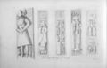
Cross No. 1 on Oronsay
Watson (2004) mentions Oronsay as a possible candidate for the site of Hinba, an island in Scotland of uncertain location that was the site of a small monastery associated with the Columban church on Iona.[3][16]
The site of a Norseship burial has been found on Oronsay and another on Colonsay dated to the mid 9th century[17] at which point these islands were likely part of the far-flung Kingdom of the Isles. Following the 1266 Treaty of Perth the Hebrides were yielded to the Kingdom of Scotland and the Gaelic language re-asserted its dominant position in the southern Hebrides.[18][19][20]
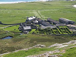
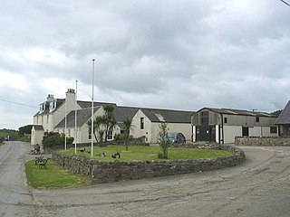
Oronsay also had a medieval Augustinian priory, the ruins of which are still extant.[21] It was built c. 1380, possibly on the site of an earlier church (for whose existence there is actually no surviving evidence), perhaps founded by John of Islay, Lord of the Isles.[22] By the early 16th century a distinct 'school' of monumental sculpture flourished on Oronsay.[23] Two substantial celtic crosses sit outside the perimeter of the buildings[3] and many slabs with effigies or other carvings are still to be found within the priory itself.[24]
16th-18th centuries
Tomb of Murchardus Macdufie, who died in 1539.
On a visit to Colonsay in the 18th century, Sir Joseph Banks was informed that Murchardus Macdufie (d. 1539) "was a factor or manager for Macdonald King of the Isles upon these islands of Oransay and Colonsay & that for his mismanagement & tyranny he was executed by order of that prince".[26]
According to Caldwell (2011) "the medieval period on Islay, Jura and Colonsay was a cultural high point"[27] but the last known Prior of Oronsay was Robert Lamont, elected in 1555. After the Scottish Reformation in 1560, the lands and property of the priory was given in commendam to Maol Choluim MacDubhthaich (Malcolm MacDuffie), at which time it would appear that the community ceased to exist.[28] The MacDuffies based their operations at the site of the old Dalriadan fort of Dun Eibhinn.[29]
Writing in 1549, Sir Donald Monro, High Dean of the Isles stated of "Orvansay" that it was a low-lying island with "ane Monasterie of Channonis" and "full of hares and polecats, with a good anchorage for Highland galleys and shallow waters".[note 3][30] In 1596 a report about the military strength of the Lords of the Isles indicated that Colonsay and Oronsay together maintained a contingent of 100 warriors who were not required to work the land.[31]
By the early 17th century land on Colonsay was held by both Clan Macfie and Clan MacDonald of Dunnyveg. In 1623 Coll Ciotach (Colkitto), a Dunnyveg mercenary, was charged with the murder of Malcolm MacFie. MacFie had been hiding on Eilean nan Ròn (an islet south-west of Oronsay) but he was spotted there by Colkitto's men, apprehended and then tied to a stone and summarily shot.[32] However, after the death of their chief, the MacFies lost control of their lands and by 1630 Colkitto held the whole of Colonsay and Oronsay from the CampbellEarl of Argyll. However, not long after this Colkitto lost his own life in the Wars of the Three Kingdoms and by 1701 the Campbells had sold both islands to a MacNeill of Knapdale, whose family held these lands until the early 20th century.[33][34]
Martin Martin observed in a 1703 publication that Oronsay:
is four miles [6km] in circumference, being for the most part a plain arable, dry, sandy soil, and is fruitful in corn and grass; it is likewise adorned with a church, chapel, and monastery... There are several burying-places here, and the tombstones for the most part have a two-handed sword engraven on them. On the south side of the church within lie the tombs of MacDuffie and of the cadets of his family; there is a ship under sail and a two-handed sword engraven on the principal tombstone and this inscription, Hic jacit Malcolumbus MacDuffie de Collonsay; his coat of arms and colour-staff is of red in a stone, through which a hole is made to hold it. There is a cross at the east and west sides of this church, which are now broken; their height was about 12 feet [3.7m] each; there is a large cross on the west side of the church, of an entire stone very hard; there is a pedestal of three steps, by which they ascend to it, it is 16 feet [5m] high, and a foot and a half [0.5m] broad; there is a large crucifix on the west side of this cross, it has an inscription underneath, but not legible, being almost worn off by the injury of time; the other side has a tree engraven on it... The natives of Colonsay are accustomed, after their arrival in Oronsay Isle, to make a tour sunways about the church, before they enter upon any kind of business.
—Martin Martin, A Description of The Western Islands of Scotland.[35]
The island is now owned by the Colburn family.
Wildlife
From one of the small beaches on the east coast of Oronsay, looking towards the Paps of Jura in the distance
The rocks and skerries of Eilean nan Ròn (Seal Island), to the south-west, are an important grey seal breeding colony. The islet has a ruined house, possibly once used by a kelp gatherer and used for sheep grazing in the summer, the rocks being fertilised by the winter-visiting barnacle geese.[21] Dean Munro also mentioned the nearby islet of Eilean Ghaoideamal under its earlier name of Ellan na muk, noting that it was "gude for swine and uther bestiall".[36][37]
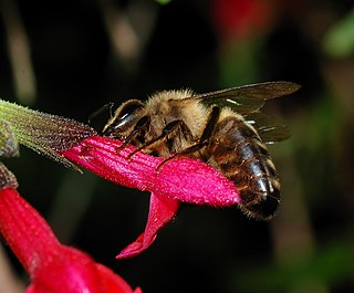
Colonsay and Oronsay are home to about 50 colonies of the European dark bee the Apis mellifera mellifera. The Scottish Government introduced the Bee Keeping (Colonsay and Oronsay) Order 2013 to prevent cross breeding with other honeybees (Apis mellifera) and to protect it from diseases common on the mainland. From 1 January 2014 it has been an offence to keep any other honeybee on either island. The Environment and climate Change Minister Paul Wheelhouse MSP said: "The Bee Keeping Order illustrates how our non-native species legislation can be used to protect our native wildlife. The order is a targeted measure to protect an important population of black bees on Colonsay from hybridisation with non-native bees" (the "non-native species legislation" was used because Apis mellifera are considered to be non-native to Colonsay, but considered native to Scotland as it was the first honey bee to be introduced for use in beekeeping there).[39] The bees on Colonsay are now referred to as the "Colonsay Dark Native Bee".[40] They were collected from across Scotland in the previous thirty years, genetic analysis has shown Australian and New Zealand A. m. ligusticaintrogression.[41]
The summit of Beinn Orasaigh with Beinn Eibhne on Colonsay beyond.
Tombs on Oronsay
Oronsay Priory was improved in anticipation of Queen Elizabeth's visit.
↑ The Gazetteer for Scotland records the area as 519 hectares.[7]
↑ This image was drawn by John Cleveley, junior, from a sketch taken on 8 August 1772. On the back of the drawing is the quotation given above, presumably made by Sir Joseph Banks who travelled to the Western Isles around 1772.[26]
↑ Monro wrote in Scots. The original is "mane laich land, full of hairis and fowmartis, with gude heavin for hieland Galays and scheald at the schoiris".
Munro, R. W. (1961) Monro's Western Isles of Scotland and Genealogies of the Clans. Edinburgh and London. Oliver and Boyd.
Murray, W. H. (1966). The Hebrides. London: Heinemann.
Murray, W.H. (1973) The Islands of Western Scotland: the Inner and Outer Hebrides. London. Eyre Methuen. ISBN0413303802
Omand, Donald (ed.) (2006) The Argyll Book. Edinburgh. Birlinn. ISBN978-1-84158-480-5
Watt, D.E.R. & Shead, N.F. (eds.) (2001) The Heads of Religious Houses in Scotland from the 12th to the 16th Centuries, The Scottish Records Society, New Series, Volume 24. Edinburgh.
Watson, W.J. (2004) The History of the Celtic Place-names of Scotland. Reprinted with an introduction by Simon Taylor. Edinburgh. Birlinn. ISBN1-84158-323-5. First published 1926.
"On the Monastic Trail: Oronsay". Hidden Europe Magazine. 17 June 2009. 2005 article that explores Columba's possible landing on Oronsay, the Priory and aspects of Oronsay life today.
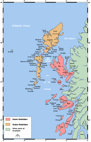
The Hebrides are an archipelago off the west coast of the Scottish mainland. The islands fall into two main groups, based on their proximity to the mainland: the Inner and Outer Hebrides.
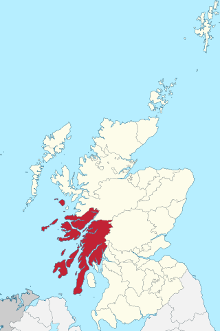
The Inner Hebrides is an archipelago off the west coast of mainland Scotland, to the south east of the Outer Hebrides. Together these two island chains form the Hebrides, which experience a mild oceanic climate. The Inner Hebrides comprise 35 inhabited islands as well as 44 uninhabited islands with an area greater than 30 hectares. Skye, Mull, and Islay are the three largest, and also have the highest populations. The main commercial activities are tourism, crofting, fishing and whisky distilling. In modern times the Inner Hebrides have formed part of two separate local government jurisdictions, one to the north and the other to the south. Together, the islands have an area of about 4,130 km2 (1,594 sq mi), and had a population of 18,948 in 2011. The population density is therefore about 4.6 inhabitants per square kilometre.
Argyll, sometimes called Argyllshire, is a historic county and registration county of western Scotland. The county ceased to be used for local government purposes in 1975 and most of the area now forms part of the larger Argyll and Bute council area.
Gigha or the Isle of Gigha is an island off the west coast of Kintyre in Scotland. The island forms part of Argyll and Bute and has a population of 163 people. The climate is mild with higher than average sunshine hours and the soils are fertile. The main settlement is Ardminish.
The Apis mellifera mellifera is a subspecies of the western honey bee, evolving in central Asia, with a proposed origin of the Tien Shan Mountains and later migrating into eastern and then northern Europe after the last ice age from 9,000BC onwards. Its original range included the southern Urals in Russia and stretched through northern Europe and down to the Pyrenees. They are one of the two members of the 'M' lineage of Apis mellifera, the other being in western China. Traditionally they were called the Black German Bee, although they are now considered endangered in Germany. However today they are more likely to be named after the region in which they live, such as the British black bee, the Native Irish Honey Bee, the Cornish black bee and the Nordic brown bee, even though they are all the same subspecies, with the word "native" often inserted by local beekeepers, even in places where the bee is an introduced foreign species. It was domesticated in Europe and hives were brought to North America in the colonial era in 1622 where they were referred to as the English Fly by the Native Americans.
The Prior of Oronsay was the Religious Superior of Oronsay Priory, a community of canons regular on the island of Oronsay, Inner Hebrides, off the coast of Scotland. It was in existence by 1353, perhaps founded by John of Islay, Lord of the Isles.
Oronsay Priory was a monastery of canons regular on the island of Oronsay, Inner Hebrides, Argyll, off the coast of Scotland. It was in existence by 1353 under the patronage of John of Islay, Lord of the Isles. It was dedicated to St. Columba, and perhaps was a continuation or a re-activation of an older foundation. Very little is known about it because of the absence of records and its remoteness from the Scottish Lowlands, but on occasions some of the Priors of Oronsay come into the records.
Clan Macfie is a Highlands Scottish Clan.
Texa is a small island 700 metres directly south of Islay, in the Inner Hebrides, Scotland. It reaches a height of 48 metres at its highest point, Ceann Garbh. It is part of the parish of Kildalton on Islay. The distilleries of Laphroaig and Lagavulin are nearby on the Islay coast, as well as Port Ellen. It is currently uninhabited, but is home to wild goats, as well as otters.
Eilean Mhuire is the most easterly of the Shiant Islands in the Outer Hebrides.
Nave Island lies to the north of Islay in the Inner Hebrides near the mouth of Loch Gruinart. It is uninhabited.
Hinba is an island in Scotland of uncertain location that was the site of a small monastery associated with the Columban church on Iona. Although a number of details are known about the monastery and its early superiors, and various anecdotes dating from the time of Columba of a mystical nature have survived, modern scholars are divided as to its whereabouts. The source of information about the island is Adomnán's late 7th-century Vita Columbae.
Colonsay is an island in the Inner Hebrides of Scotland, located north of Islay and south of Mull. The ancestral home of Clan Macfie and the Colonsay branch of Clan MacNeil, it is in the council area of Argyll and Bute and has an area of 4,074 hectares. Aligned on a south-west to north-east axis, it measures 8 miles in length and reaches 3 mi (5 km) at its widest point.
Islay is the southernmost island of the Inner Hebrides of Scotland. Known as "The Queen of the Hebrides", it lies in Argyll and Bute just south west of Jura and around 40 kilometres north of the Northern Irish coast. The island's capital is Bowmore where the distinctive round Kilarrow Parish Church and a distillery are located. Port Ellen is the main port.
The Sound of Islay is a narrow strait between the islands of Islay and Jura off the west coast of Scotland. It is about 30 kilometres in extent from north to south and lies between Rubh' a' Mhàil on Islay and Rubh' Aird na Sgitheich on Jura to the north and Macarthur's Head and Rubha na Tràille to the south. The islands in the Sound are Am Fraoch Eilean, Brosdale Island and Glas Eilean, all of which are off the south east coast of Jura. These islands, Jura south of Loch Tarbert and the eastern part of the Sound are one of 40 National Scenic Areas in Scotland.
The modern names of Scottish islands stem from two main influences. There are many names that derive from the Scottish Gaelic language in the Hebrides and Firth of Clyde. In the Northern Isles most place names have a Norse origin. There are also some island place names that originate from three other influences, including a limited number that are essentially English language names, a few that are of Brittonic origin and some of an unknown origin that may represent a pre-Celtic language. These islands have all been occupied by the speakers of at least three and in many cases four or more languages since the Iron Age, and many of the names of these islands have more than one possible meaning as a result.
Description of the Western Isles of Scotland is the oldest known account of the Hebrides and the Islands of the Clyde, two chains of islands off the west coast of Scotland. The author was Donald Monro, a clergyman who used the title of "Dean of the Isles" and who lived through the Scottish Reformation. Monro wrote the original manuscript in 1549, although it was not published in any form until 1582 and was not widely available to the public in its original form until 1774. A more complete version, based on a late 17th-century manuscript written by Sir Robert Sibbald, was first published as late as 1961. Monro wrote in Scots and some of the descriptions are difficult for modern readers to render into English. Although Monro was criticised for publishing folklore and for omitting detail about the affairs of the churches in his diocese, Monro's Description is a valuable historical account and has reappeared in part or in whole in numerous publications, remaining one of the most widely quoted publications about the western islands of Scotland.
This page is based on this Wikipedia article Text is available under the CC BY-SA 4.0 license; additional terms may apply. Images, videos and audio are available under their respective licenses.