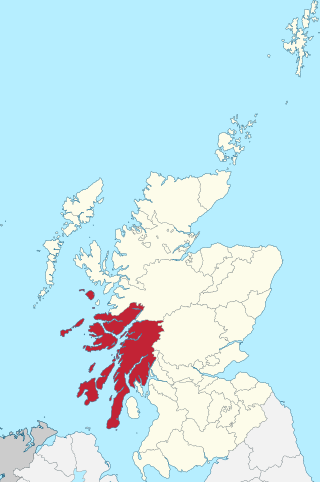
Argyll and Bute is one of 32 unitary council areas in Scotland and a lieutenancy area. The current lord-lieutenant for Argyll and Bute is Jane Margaret MacLeod. The administrative centre for the council area is in Lochgilphead at Kilmory Castle, a 19th-century Gothic Revival building and estate. The current council leader is Councillor Jim Lynch.

The Inner Hebrides is an archipelago off the west coast of mainland Scotland, to the south east of the Outer Hebrides. Together these two island chains form the Hebrides, which experience a mild oceanic climate. The Inner Hebrides comprise 35 inhabited islands as well as 44 uninhabited islands with an area greater than 30 hectares. Skye, Mull, and Islay are the three largest, and also have the highest populations. The main commercial activities are tourism, crofting, fishing and whisky distilling. In modern times the Inner Hebrides have formed part of two separate local government jurisdictions, one to the north and the other to the south. Together, the islands have an area of about 4,130 km2 (1,594 sq mi), and had a population of 18,948 in 2011. The population density is therefore about 4.6 inhabitants per square kilometre.
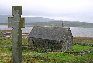
Lismore is an island of some 2,351 hectares in the Inner Hebrides of Scotland. The climate is damp and mild, with over 166 centimetres (65 in) of rain recorded annually. This fertile, low-lying island was once a major centre of Celtic Christianity, with a 6th-century monastery associated with Saint Moluag, and later became the seat of the medieval Bishop of Argyll. There are numerous ruined structures, including a broch and two 13th-century castles.

The County of Bute, also known as Buteshire, is a historic county and registration county of Scotland. Now replaced by Argyll and Bute for the Isle of Bute, with the Argyll and Bute Council. The Isle of Arran and The Cumbraes are now in North Ayrshire Council area. Since the implementation of the Local Government etc. (Scotland) Act 1994, on the 1 April 1996.
Argyll, sometimes called Argyllshire, is a historic county and registration county of western Scotland. The county ceased to be used for local government purposes in 1975 and most of the area now forms part of the larger Argyll and Bute council area.

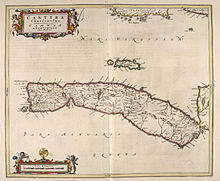
Kintyre is a peninsula in western Scotland, in the southwest of Argyll and Bute. The peninsula stretches about 30 miles, from the Mull of Kintyre in the south to East and West Loch Tarbert in the north. The region immediately north of Kintyre is known as Knapdale.
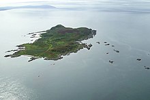
Gigha or the Isle of Gigha is an island off the west coast of Kintyre in Scotland. The island forms part of Argyll and Bute and has a population of 163 people. The climate is mild with higher than average sunshine hours and the soils are fertile. The main settlement is Ardminish.
Coll is an island located west of the Isle of Mull and northeast of Tiree in the Inner Hebrides of Scotland. Coll is known for its sandy beaches, which rise to form large sand dunes, for its corncrakes, and for Breacachadh Castle. It is in the council area of Argyll and Bute. Arinagour is the main settlement on Coll. There is a ferry terminal on the island which connects it with the mainland of Scotland. Coll also has a small airport. The island is rural in nature and has been awarded Dark Sky status.

Tiree is the most westerly island in the Inner Hebrides of Scotland. The low-lying island, southwest of Coll, has an area of 7,834 hectares and a population of around 650.
Great Bernera, often known just as Bernera, is an island and community in the Outer Hebrides of Scotland. With an area of just over 21 square kilometres, it is the thirty-fourth largest Scottish island.
Sanda Island is a small island in the Firth of Clyde, off of Argyll and Bute, Scotland, near the southern tip of the Kintyre peninsula, near Southend and Dunaverty Castle.

Lord of the Isles or King of the Isles (Scottish Gaelic: Triath nan Eilean or Rìgh Innse Gall; Latin: Dominus Insularum) is a title of nobility in the Baronage of Scotland with historical roots that go back beyond the Kingdom of Scotland. It began with Somerled in the 12th century and thereafter the title was held by a series of his descendants, the Norse-Gaelic rulers of the Isle of Man and Argyll and the islands of Scotland in the Middle Ages. They wielded sea-power with fleets of galleys (birlinns). Although they were, at times, nominal vassals of the kings of Norway, Ireland, or Scotland, the island chiefs remained functionally independent for many centuries. Their territory included much of Argyll, the Isles of Arran, Bute, Islay, the Isle of Man, Hebrides, Knoydart, Ardnamurchan, and the Kintyre peninsula. At their height they were the greatest landowners and most powerful lords after the kings of England and Scotland.
Knapdale forms a rural district of Argyll and Bute in the Scottish Highlands, adjoining Kintyre to the south, and divided from the rest of Argyll to the north by the Crinan Canal. It includes two parishes, North Knapdale and South Knapdale. The area is bounded by sea to the east and west, whilst the sea loch of West Loch Tarbert almost completely cuts off the area from Kintyre to the south. The name is derived from two Gaelic elements: Cnap meaning hill and Dall meaning field.

Skye and Lochalsh was a local government district, created in 1975 as one of eight districts within the Highland region in Scotland. It include the Isle of Skye and the Lochalsh area on the mainland. The main offices of the council were in Portree, on the Isle of Skye. The district was abolished in 1996 when Highland was made a single-tier council area.

Clan Donald, also known as Clan MacDonald or Clan Mc Donald, is a Highland Scottish clan and one of the largest Scottish clans. The Lord Lyon King of Arms, the Scottish official with responsibility for regulating heraldry in that country, issuing new grants of coats of arms, and serving as the judge of the Court of the Lord Lyon, recognises under Scottish law the High Chief of Clan Donald. Historically the chiefs of the Clan Donald held the title of Lord of the Isles until 1493 and two of those chiefs also held the title of Earl of Ross until 1476.
Tarbert is a place name in Scotland and Ireland. Places named Tarbert are characterised by a narrow strip of land, or isthmus. This can be where two lochs nearly meet, or a causeway out to an island.

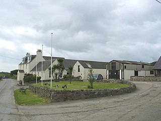
Tayinloan is a village situated on the west coast of the Kintyre peninsula in Argyll and Bute, Scotland. The village has a sub post office, general store and a small hotel, a village hall and a play park. There is a cafe bar situated beside the ferry car park which also offers self-catering or bed and breakfast accommodation. The nearest towns are Campbeltown and Tarbert.

Clan Macfie is a Highlands Scottish Clan.
Largie Castle is a former mansion house at Tayinloan, Kintyre, Argyll and Bute, Scotland. It was designed by architect Charles Wilson for The Hon. Augustus Moreton Macdonald and built in 1857–9. It was demolished in 1958.
Angus MacDonald, 8th of Dunnyveg was the Chief of Clan MacDonald of Dunnyveg.