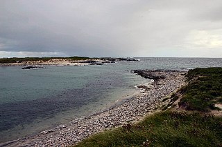
Ceann Iar (Gaelic "Western Headland") is one of the Monach Isles/Heisgeir, to the west of North Uist in the Outer Hebrides. It is a slender island, approximately a mile, or two kilometres long.
Cnoc Bhàrr is the highest point of the Monach Islands, at a mere 19 metres. Siolaigh/Shillay can be seen in the distance
Ceann Iar is the second largest of the Monach Islands. It is connected at low tide to Ceann Ear via Sibhinis. It is said that it was at one time possible to walk all the way to Baleshare, and on to North Uist, five miles away, at low tide. In the 16th century, a large tidal wave was said to have washed this[what?] away.[3] Despite Ceann Iar's name, Shillay is in fact the westernmost of the group.
Like the other islands of the group, it is a low-lying, sandy island, subject to intense coastal erosion. Not unlike the Isles of Scilly, it is possible that Ceann Iar, Sibhinis and Ceann Ear formed a single body of land within historic times, and that their land area has greatly decreased due to overgrazing, and wind erosion as well.
On the east side is Baile Beag (little town), the settlement of the island, on the slopes of Cnoc Bhàrr (top hill), which at 19 metres in height is a mere metre higher than neighbouring Ceann Ear's hillocks. In the north, there is also Cnoc Mòr (big hill), which is the other "height" on the island. The west is formed by Rubha Shulabhaig (a headland), and the north east by Hearnish. Just to the north is the island of S(t)ròmaigh (from Old Norse meaning "storm island")
Ruins on Ceann Iar
History
A cairn on Ceann Iar marks the grave of Lieutenant RNR MacNeill of the HMA Laurentic. The ship hit a mine in 1917, during World War I, off Northern Ireland, and his body had drifted all the way to here. Strangely, this accords with the old Hebridean tradition that the sea carries the drowned home - the Monachs are Clan MacNeil territory.
The island had been settled intermittently for over a thousand years, although the main settlement was on Ceann Ear. It was resettled in the wake of the Highland Clearances, but finally abandoned in 1942.
The Outer Hebrides or Western Isles, sometimes known as the Long Isle or Long Island, is an island chain off the west coast of mainland Scotland. The islands are geographically coextensive with Comhairle nan Eilean Siar, one of the 32 unitary council areas of Scotland. They form part of the archipelago of the Hebrides, separated from the Scottish mainland and from the Inner Hebrides by the waters of the Minch, the Little Minch, and the Sea of the Hebrides.
Eriskay, from the Old Norse for "Eric's Isle", is an island and community council area of the Outer Hebrides in northern Scotland with a population of 143, as of the 2011 census. It lies between South Uist and Barra and is connected to South Uist by a causeway which was opened in 2001. In the same year Ceann a' Ghàraidh in Eriskay became the ferry terminal for travelling between South Uist and Barra. The Caledonian MacBrayne vehicular ferry travels between Eriskay and Ardmore in Barra. The crossing takes around 40 minutes.
Grimsay is a tidal island in the Outer Hebrides of Scotland.
Uist is a group of six islands that are part of the Outer Hebridean Archipelago, which is part of the Outer Hebrides of Scotland.
Berneray is an island and community in the Sound of Harris, Scotland. It is one of fifteen inhabited islands in the Outer Hebrides. It is famed for its rich and colourful history which has attracted much tourism. It lies within the South Lewis, Harris and North Uist National Scenic Area, one of 40 such areas in Scotland which are defined so as to identify areas of exceptional scenery and to ensure its protection from inappropriate development.
Baleshare is a flat tidal island in the Outer Hebrides of Scotland. Baleshare lies to the south-west of North Uist. Its economics and community were boosted by the building of a causeway in 1962. The 350-metre (380 yd) causeway was built by William Tawse Ltd. The island is extremely flat by Hebridean standards, rising to only 12 metres above sea level and known for its long sandy beach. It has a population of 49 living in two settlements: Samhla and Teananachar.
Vallay is an uninhabited tidal island in the Scottish Outer Hebrides. It can be reached from North Uist by a long beach at low tide.
Ronay is an island in the Outer Hebrides of Scotland, which lies a short distance off the east coast of Grimsay.
The Isle of Ewe is a small Scottish island on the west coast of Ross and Cromarty. The island is inhabited by a single extended family, the Grants, who have lived at the current settlement on the leeward NE side of the island since the 19th century.
Ceann Ear is the largest island in the Monach or Heisgeir group off North Uist in north west Scotland. It is 203 hectares in size and connected by sandbanks to Ceann Iar via Sibhinis at low tide. It is said that it was at one time possible to walk all the way to Baleshare, and on to North Uist, 5 miles away at low tide. In the 16th century, a large tidal wave was said to have washed this away.
Shillay is the westernmost of the Monach Islands (Heisgeir), off North Uist in the Outer Hebrides.
Hermetray is an uninhabited island off North Uist, in the Outer Hebrides of Scotland.
Na h-Eileanan Iasgaich comprise a small uninhabited archipelago in Loch Boisdale, in the south east of the island of South Uist, in the Outer Hebrides, Scotland. The individual islands are separated from one another at high tide, but connected to one another at low tide,. They are around 50 ha in extent and over 20m at their highest point. Their boundaries are ill-defined.
Sibhinis, Siobhanais or Shivinish. is one of the Monach Islands, lying between Ceann Iar and Ceann Ear. It is tidal, and connected at low tide to Ceann Iar by Fadhail Shibhinis, and to Ceann Ear by Faodhail Chinn Ear. It is 16 metres at its highest point. It is said that it was at one time possible to walk all the way to Baleshare, and on to North Uist, five miles (8 km) away at low tide. In the 16th century, a large tidal wave was said to have washed this away.
Ceallasaigh Mòr is a low-lying island in Loch Maddy off North Uist in the Outer Hebrides of Scotland. This an area of shallow lagoons filled and drained by the tides each day. Ceallasaigh Beag lies to the south and these two islets are connected by a narrow strip of sand at low tide. Ceallasaigh Mòr may also join mainland North Uist near Bràigh Cheallasaigh at some stages of the tide.
Fraoch-eilean is a small island with an uncertain population north of Benbecula in the Outer Hebrides of Scotland. It is about 55 hectares in extent and the highest point is 11 metres (36 ft). Its name derives from the Gaelic for "heather island".
Ceallasaigh Beag is a low-lying island in Loch Maddy off North Uist in the Outer Hebrides of Scotland. This an area of shallow lagoons filled and drained by the tides each day. Ceallasaigh Mòr lies to the south and these two islets are connected by a narrow strip of sand during some low tides.
The Monach Islands, also known as Heisker, are an island group west of North Uist in the Outer Hebrides of Scotland. The islands are not to be confused with Hyskeir in the Inner Hebrides, or Haskeir which is also off North Uist and visible from the group.
This page is based on this Wikipedia article Text is available under the CC BY-SA 4.0 license; additional terms may apply. Images, videos and audio are available under their respective licenses.