There are several peaks on the island including Beinn a' Chàrnain in the west (mountain of the small cairn; 73m or 240ft), Meall Meadhonach (middle rounded hill; 79m or 259ft) and Meall Mòr (east of Meall Meadhonach and south of the peninsula of Càrais; 76m or 249ft).
Wildlife
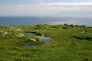
Along with a variety of seabirds, raptors including falcons and golden eagles have been seen on Hellisay.[3] The island has a profusion of sea thrift[3] and the Sound of Gighay has been described as a "quiet secret place of wild irises and marshmallows".[5]
History
The island's name is Old Norse in origin. It possibly means "island of the caves", which appears to be confirmed by the name Rubha na h-Uamh (headland of the cave) in the east of the island. However, Blaeu's map has "Hildesay", which suggests that the name may derive from the Norse for "Hilda's Island".[3]
The island's settlement was at Buaile Mhòr (anglicised to Bualavore and meaning "the big fold") near Eilean a' Ghamhna in the north west of the island. The remains of a sheep pen and a well can still be seen.
Like so many other islands in the region, Hellisay was badly affected by the Highland Clearances. Firstly, refugees from clearances in neighbouring islands swelled the population, and latterly the island's inhabitants themselves were evicted, and many went to live on Eriskay. The population peaked at 108 in 1841, and the island was cleared in the 1840s – however it continued to have some inhabitants up until 1890.[3]
Alasdair Alpin MacGregor's stories reveal a rich folklore and mythology extant on the island, possibly only a fraction of which has been preserved.[3]
In Media
Franciscan priest, specialist in mystical theology and author Rayner Torrington wrote a book describing how he was influenced by meeting a hermit called Peter Calvay who lived on Hellisay for a number of years in the first half of the twentieth century.[6] The book titled ‘Peter Calvay, hermit: A personal rediscovery of prayer’ was first published in 1977 and has had at least eleven reprintings. Torkington's book ‘Wisdom from the Western Isles: the making of a mystic’, published in 2008, also describes the author's meetings with Peter Calvay whilst the author was staying on the nearby island of Barra.[7]
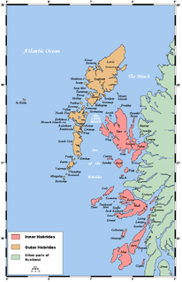
The Hebrides are a Scottish archipelago off the west coast of the Scottish mainland. The islands fall into two main groups, based on their proximity to the mainland: the Inner and Outer Hebrides.
Soay is an island just off the coast of Skye, in the Inner Hebrides of Scotland.
The Outer Hebrides or Western Isles, sometimes known as Na h-Innse Gall or the Long Isle/Long Island, is an island chain off the west coast of mainland Scotland. The islands are geographically coextensive with Comhairle nan Eilean Siar, one of the 32 unitary council areas of Scotland. They form part of the archipelago of the Hebrides, separated from the Scottish mainland and from the Inner Hebrides by the waters of the Minch, the Little Minch, and the Sea of the Hebrides. Scottish Gaelic is the predominant spoken language, although in a few areas English speakers form a majority.
Barra is an island in the Outer Hebrides, Scotland, and the second southernmost inhabited island there, after the adjacent island of Vatersay to which it is connected by a short causeway. The island is named after Saint Finbarr of Cork.
Barra Head, also known as Berneray, is the southernmost island of the Outer Hebrides in Scotland. Within the Outer Hebrides, it forms part of the Barra Isles archipelago. Originally, Barra Head only referred to the southernmost headland of Berneray but is now a common name for the entire island. The highest point of the island is Sotan, a Marilyn.
Isay is an uninhabited island in the Inner Hebrides of the west coast of Scotland. It lies in Loch Dunvegan, 1 kilometre (1,100 yd) off the northwest coast of the Isle of Skye. Two smaller isles of Mingay and Clett lie nearby. The name originated from the Old Norse ise-øy meaning porpoise island. The island of Lampay is due south. The area of Isay is 60 hectares.
Gighay an uninhabited island off the northeast coast of Barra. It is one of ten islands in the Sound of Barra, a Site of Community Importance for conservation in the Outer Hebrides of Scotland.
Ceann Iar is one of the Monach Isles/Heisgeir, to the west of North Uist in the Outer Hebrides. It is a slender island, approximately a mile, or two kilometres long.
Hermetray is an uninhabited island off North Uist, in the Outer Hebrides of Scotland.
Stuley is an island lying to the east of South Uist in the Outer Hebrides, Scotland. It lies off the section of coastline between Loch Eynort and Loch Boisdale. It is 45 hectares (0.17 sq mi) and 40 metres (131 ft) at its highest point.
Flodday or Flodaigh, is a currently uninhabited island that lies to the north east of Barra and is one of ten islands in the Sound of Barra, a Site of Community Importance for conservation in the Outer Hebrides, Scotland. Its name derives from the Old Norse for "flat island".
Fuiay is an island in Scotland. It is one of ten islands in the Sound of Barra, a Site of Community Importance for conservation in the Outer Hebrides. Its area is 84 ha and the unnamed highest eminence reaches 107 m. It is located immediately to the west of Flodday and about 1.5 km southwest of Hellisay. Barra lies across the waters of North Bay.
Orosay is a small uninhabited tidal island in the Sound of Barra lying at the north end of Traigh Mhòr, the ‘big beach’ on the north east coast of Barra. It is one of ten islands in the Sound of Barra, a Site of Community Importance for conservation in the Outer Hebrides of Scotland. It is about 30 hectares in extent and the highest point is 38 metres (125 ft).
Eilean Meadhonach is the second largest of the Crowlin Islands, located in the Inner Sound off the island of Skye, Scotland.
The Sound of Barra is a large ocean inlet or sound situated to the north of the isle of Barra and to the south of South Uist in the Outer Hebrides in Scotland. Since 2014 it has been designated as a Special Area of Conservation (SAC). The Sound of Barra is composed of 98.91% marine and inlet areas, 1.07% mudflats and other semi-submerged areas and 0.02% sea cliffs and islets. There are ten islands in the sound, with only Eriskay still being inhabited:
This page is based on this Wikipedia article Text is available under the CC BY-SA 4.0 license; additional terms may apply. Images, videos and audio are available under their respective licenses.