Horse Island, Summer Isles

Last updated

Horse Island
Scottish Gaelic nameEilean nan Each
Location
Highland UK relief location map.jpg
Red pog.svg
Horse Island
En Mhic Coinnich shown within Highland Scotland
OS grid reference NC023045
Coordinates 57°59′N5°20′W / 57.99°N 5.34°W / 57.99; -5.34
Physical geography
Island group Summer Isles
Area53 ha (316 sq mi)
Area rank196= [1]
Highest elevationSgùrr nan Uan, 60 m (197 ft)
Administration
Sovereign state United Kingdom
Country Scotland
Council area Highland
Demographics
Population0
Lymphad3.svg
References [2] [3] [4]
Horse Island from Badenscaillie Horseisland.jpg
Horse Island from Badenscaillie

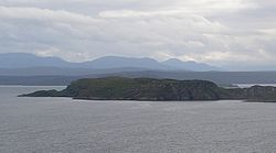
Horse Island (Scottish Gaelic : Eilean nan Each) is an uninhabited island in the Summer Isles, in the north west of Scotland.

Once inhabited, the island now only supports a herd of wild goats. [5] [6] It rises to a maximum elevation of 60 metres (197 feet) at Sgùrr nan Uan ("peak of the lambs").

Footnotes

  1. Area and population ranks: there are c.300 islands over 20ha in extent and 93 permanently inhabited islands were listed in the 2011 census.
  2. 2001 UK Census per List of islands of Scotland
  3. Haswell-Smith, Hamish (2004). The Scottish Islands. Edinburgh: Canongate. ISBN   978-1-84195-454-7.
  4. Ordnance Survey
  5. Perrott, David (1988). Guide to the Western Islands of Scotland. Edinburgh: Kittiwake Press. ISBN   0-7028-0886-5.
  6. "Overview of Horse Island". Gazetteer for Scotland . Retrieved 15 December 2007.

Coordinates: 57°59′10″N5°20′40″W / 57.98611°N 5.34444°W / 57.98611; -5.34444


Related Research Articles

Soay is an island just off the coast of Skye, in the Inner Hebrides of Scotland.

Eriskay, from the Old Norse for "Eric's Isle", is an island and community council area of the Outer Hebrides in northern Scotland with a population of 143, as of the 2011 census. It lies between South Uist and Barra and is connected to South Uist by a causeway which was opened in 2001. In the same year Ceann a' Ghàraidh in Eriskay became the ferry terminal for travelling between South Uist and Barra. The Caledonian MacBrayne vehicular ferry travels between Eriskay and Ardmore in Barra. The crossing takes around 40 minutes.

Scalpay is an inhabited island in the Inner Hebrides of Scotland which has a population of 4.

Torsa is one of the Slate Islands in Argyll and Bute, Scotland. Lying east of Luing and south of Seil, this tidal island was inhabited until the 1960s. There is now only one house there, which is used for holiday lets. The underlying bedrock is slate but unlike Torsa's immediate island neighbours this has never been worked commercially. The island's name is of Norse origin but the most prominent historical structure on the island is the ruined Caisteal nan Con on the northeast shore, once held by Clan Campbell. The abundant sea life in the waters surrounding the island are protected by the Loch Sunart to the Sound of Jura Marine Protected Area.

Ronay

Ronay is an island in the Outer Hebrides of Scotland, which lies a short distance off the east coast of Grimsay.

Sgeotasaigh

Scotasay is small island in the Outer Hebrides of Scotland. It lies 1 kilometre off the east coast of Harris and gives some shelter to the ferry port of Tarbert. There are two houses on the island, a wind turbine and a fresh water tank.

Shillay

Shillay is an uninhabited island which lies 2 km north of Pabbay in the Outer Hebrides of Scotland.

Ensay is a currently unpopulated and privately owned island in the Outer Hebrides of Scotland. The island lies in the Sound of Harris between the islands of Harris and Berneray. The name originates from the Old Norse for Ewe Island. It is nothing to do with the Gaelic for Jesus – "Iosa" – as sometimes stated.

Eilean nan Ròn

Eilean nan Ròn is an island near Skerray, in the north of Sutherland, Scotland. An estimated 350 seal pups are born here annually.

Longay

Longay is a small uninhabited Scottish island in the Inner Sound just off the coast of the Isle of Skye, north of Pabay and east of Scalpay.

Flodaigh

Flodaigh is a tidal island lying to the north of Benbecula and south of Grimsay in the Outer Hebrides, Scotland. It is connected to Benbecula by a causeway.

Oronsay, Outer Hebrides

Oronsay is a tidal island off North Uist in the Outer Hebrides. Lying to the north of Vallaquie Strand, the island has been uninhabited since the Highland Clearances.

Longa Island is a small uninhabited island at the mouth of Loch Gairloch, on the west coast of Scotland. Longa is nearly one mile in length with an area of 126 hectares and a maximum elevation of 70 metres (230 ft) above sea level.

Soay Mòr

Soay Mòr is an island in West Loch Tarbert, between the northern and southern parts of Harris. The uninhabited island is separated from the southwest coast of North Harris by the Soay Sound. The adjacent Soay Beag is accessible on foot at low tide.

Ceann Ear is the largest island in the Monach or Heisgeir group off North Uist in north west Scotland. It is 203 hectares in size and connected by sandbanks to Ceann Iar via Sibhinis at low tide. It is said that it was at one time possible to walk all the way to Baleshare, and on to North Uist, 5 miles away at low tide. In the 16th century, a large tidal wave was said to have washed this away.

Island Macaskin or MacAskin is an island in Loch Craignish, in the Inner Hebrides of Scotland. It is owned by the Jenkin family and has been since 1904.

Oldany Island is an uninhabited island in Assynt, Sutherland, north-west Scotland.

Eilean Mòr, Crowlin Islands

Eilean Mòr is the largest of the Crowlin Islands in the Inner Sound off the Isle of Skye, Scotland.

Nave Island

Nave Island lies to the north of Islay in the Inner Hebrides near the mouth of Loch Gruinart. It is uninhabited.

Flodaigh Mòr is an uninhabited island in the Outer Hebrides of Scotland.