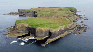
The island is named after St Kenneth, a follower of Saint Columba, who is said to have founded a monastery on the island.
Ownership and visitors
The house on Inch Kenneth
The island was visited in 1773 by Samuel Johnson and James Boswell during their tour of the Hebrides; they were entertained there by Sir Allan MacLean, head of the Maclean clan. Both Johnson[5] and Boswell[6] published accounts of their visit.
In the early 1930s the island was owned by Sir Harold Boulton, 2nd Baronet, the writer of the words to the Skye Boat Song. He enlarged an earlier house to make the existing mansion, dying in 1935.
The island's most celebrated subsequent owner in the twentieth century was the Mitford family. Nazi sympathiser Unity Mitford spent her final years on the island.[7] Following the death of their father, Lord Redesdale, the island was inherited under Scots law by the surviving Mitford sisters and not his wife, as Lord Redesdale had willed it to his only son Tom, who had predeceased him. When their mother died in 1963, Nancy gave her share to Jessica, who bought the shares of Diana, Deborah and Pamela.[8] Jessica, a former communist, teasingly suggested that it might become a Soviet submarine base.
The island was sold by Jessica in the late 1960s to Andrew Barlow, son of Sir Alan Barlow, 2nd Baronet. It remains with their family.
Other
The island was a location for the 1993 feature film Walk Me Home produced by author Timothy Neat.[9]
Inch Kenneth is classified by the National Records of Scotland as an inhabited island that "had no usual residents at the time of either the 2001 or 2011 censuses."[10]
Wikimedia Commons has media related to Inch Kenneth.
Related Research Articles
Soay is an island just off the coast of Skye, in the Inner Hebrides of Scotland.
Staffa is an island of the Inner Hebrides in Argyll and Bute, Scotland. The Vikings gave it this name as its columnar basalt reminded them of their houses, which were built from vertically placed tree-logs.
Muck is the smallest of four main islands in the Small Isles, part of the Inner Hebrides of Scotland. Today, much of the island is used for grazing. Residents use wool to make rugs and clothing. There are several ancient monuments and some facilities for visitors. The few residents are served by a single school, Muck Primary School & Nursery. The island is owned by the MacEwen family.
Scalpay is an inhabited island in the Inner Hebrides of Scotland which has a population of 4.
Ulva is a small island in the Inner Hebrides of Scotland, off the west coast of Mull. It is separated from Mull by a narrow strait, and connected to the neighbouring island of Gometra by a bridge. Much of the island is formed from Cenozoic basalt rocks, which are formed into columns in places.
The Treshnish Isles are an archipelago of small islands and skerries, lying west of the Isle of Mull, in Scotland. They are part of the Inner Hebrides. Trips to the Treshnish Isles operate from Ulva Ferry, Tobermory, Ardnamurchan and Tiree.
Gometra is an island in the Inner Hebrides of Scotland, lying west of Mull. It lies immediately west of Ulva, to which it is linked by a bridge, and at low tide also by a beach. It is approximately 425 hectares in size. The name is also applied to the island summit, which is a Marilyn. The island has been owned since 1991 by Roc Sandford, a wealthy environmental campaigner who lives mostly in London and part of the year on Gometra.
Little Colonsay is an uninhabited island west of the island of the Isle of Mull in Scotland. The geology of the island is columnar basalt, similar to that of neighbouring Staffa. It is part of the Loch Na Keal National Scenic Area, one of 40 in Scotland.
Ullinish is a crofting township on Loch Bracadale, on the southwest coast of Skye, Scotland. The only promontory fort on Skye is located at Ullinish. It is situated to the west of Struan and just south of the hamlet of Ebost. Historically, Ullinish is associated with the MacLeod family. Of literary note, Samuel Johnson's views and denunciation of James Macpherson's Ossian were confirmed while Johnson was in Ullinish.
Wiay, pronounced "waya" is an uninhabited island in Loch Bracadale, off the coast of the Isle of Skye
Eorsa is an uninhabited island in the Inner Hebrides of Scotland.
A Journey to the Western Islands of Scotland (1775) is a travel narrative by Samuel Johnson about an eighty-three-day journey through Scotland, in particular the islands of the Hebrides, in the late summer and autumn of 1773. The sixty-three-year-old Johnson was accompanied by his thirty-two-year-old friend of many years James Boswell, who was also keeping a record of the trip, published in 1785 as A Journal of a Tour to the Hebrides. The two narratives are often published as a single volume, which is beneficial for comparing two perspectives of the same events, although they are very different in approach---Johnson focused on Scotland, and Boswell focused on Johnson. In that biography, Boswell gave the itinerary of the trip as beginning at Edinburgh after landing at Berwick upon Tweed, then to St Andrews, Aberdeen, Inverness, and Fort Augustus. From there they went on to the islands of the Hebrides: Skye, Raasay, Coll, Mull, Inch Kenneth, and Iona. Returning to the mainland in Argyll they visited Inverary, Loch Lomond, Dumbarton, Glasgow, Loudoun, Auchinleck in Ayrshire, and Hamilton, and then finished the journey by returning to Edinburgh. Boswell summarised the trip as, "[Johnson] thus saw the four Universities of Scotland, its three principal cities, and as much of the Highland and insular life as was sufficient for his philosophical contemplation."
Cairn na Burgh Mòr is one of the Treshnish Isles in the Inner Hebrides of Scotland.
Samalan Island is a small island, just off the Isle of Mull at the mouth of Loch na Keal in the Inner Hebrides, Scotland. To its south west is the island of Inchkenneth, and to its north, the island of Ulva.
Sir Allan Maclean, 6th Baronet of Morvern was the 22nd Clan Chief of Clan Maclean from 1750 till his death in 1783. He was the 4th Laird of Brolas. He died without leaving a male heir to his title, so the title was bestowed on his closest living male relative, a fourth cousin, Sir Hector Maclean, 7th Baronet.
Loch Tuath is a sea loch in the Inner Hebrides, Scotland that separates the Isle of Mull and the island of Ulva. Loch Tuath forms part of the Loch na Keal National Scenic Area, one of the forty national scenic areas in Scotland, which are defined so as to identify areas of exceptional scenery and to ensure its protection from inappropriate development.
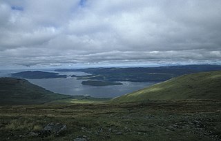
Loch na Keal, meaning Loch of the Kyle, or Narrows, also Loch of the Cliffs, is the principal sea loch on the western, or Atlantic coastline of the island of Mull, in the Inner Hebrides, Argyll and Bute, Scotland. Loch na Keal extends over 20 kilometres (12 mi) inland, almost bisecting Mull, and extending to within 5 km (3 mi) of the eastern shore. The loch gives its name to the Loch na Keal National Scenic Area, one of forty national scenic areas in Scotland.
This page is based on this Wikipedia article Text is available under the CC BY-SA 4.0 license; additional terms may apply. Images, videos and audio are available under their respective licenses.