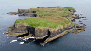
Staffa is an island of the Inner Hebrides in Argyll and Bute, Scotland. The Vikings gave it this name as its columnar basalt reminded them of their houses, which were built from vertically placed tree-logs.
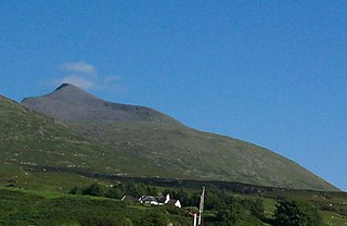
Ben More is the highest mountain and only Munro on the Isle of Mull, Scotland. It is also the highest peak in the Scottish isles – and the only Munro – apart from those on the Isle of Skye. The mountain is situated close to the centre of the island, above the shores of Loch na Keal.

Loch Ryan is a Scottish sea loch that acts as an important natural harbour for shipping, providing calm waters for ferries operating between Scotland and Northern Ireland. The town of Stranraer is the largest settlement on its shores, with ferries to and from Northern Ireland operating from Cairnryan further north on the loch.

Volcanic activity is a major part of the geology of Canada and is characterized by many types of volcanic landform, including lava flows, volcanic plateaus, lava domes, cinder cones, stratovolcanoes, shield volcanoes, submarine volcanoes, calderas, diatremes, and maars, along with less common volcanic forms such as tuyas and subglacial mounds.
Lochaline is the main village in the Morvern area of Highland, Scotland. The coastal village is situated at the mouth of Loch Aline, on the northern shore of the Sound of Mull. A ferry operates regularly over to Fishnish on the Isle of Mull.

The North Atlantic Igneous Province (NAIP) is a large igneous province in the North Atlantic, centered on Iceland. In the Paleogene, the province formed the Thulean Plateau, a large basaltic lava plain, which extended over at least 1.3 million km2 (500 thousand sq mi) in area and 6.6 million km3 (1.6 million cu mi) in volume. The plateau was broken up during the opening of the North Atlantic Ocean leaving remnants preserved in north Ireland, west Scotland, the Faroe Islands, northwest Iceland, east Greenland, western Norway and many of the islands located in the north eastern portion of the North Atlantic Ocean. The igneous province is the origin of the Giant's Causeway and Fingal's Cave. The province is also known as Brito–Arctic province and the portion of the province in the British Isles is also called the British Tertiary Volcanic Province or British Tertiary Igneous Province.

The Ross of Mull is the largest peninsula of the Isle of Mull, about 28 kilometres (17 mi) long, and makes up the south-western part of the island. It is bounded to the north by Loch Scridain and to the south by the Firth of Lorne. The main villages are Bunessan and Fionnphort, with smaller settlements including Ardtun, Camas, Carsaig, Knockan, Pennyghael and Uisken. Knocknafenaig, Suidhe, and Shiaba are three of the many cleared settlements on the Ross.

The geology of Tasmania is complex, with the world's biggest exposure of diabase, or dolerite. The rock record contains representatives of each period of the Neoproterozoic, Paleozoic, Mesozoic and Cenozoic eras. It is one of the few southern hemisphere areas that were glaciated during the Pleistocene with glacial landforms in the higher parts. The west coast region hosts significant mineralisation and numerous active and historic mines.

Volcanism in Northern Canada has produced hundreds of volcanic areas and extensive lava formations across Northern Canada. The region's different volcano and lava types originate from different tectonic settings and types of volcanic eruptions, ranging from passive lava eruptions to violent explosive eruptions. Northern Canada has a record of very large volumes of magmatic rock called large igneous provinces. They are represented by deep-level plumbing systems consisting of giant dike swarms, sill provinces and layered intrusions.

The Auckland Region of New Zealand is built on a basement of greywacke rocks that form many of the islands in the Hauraki Gulf, the Hunua Ranges, and land south of Port Waikato. The Waitākere Ranges in the west are the remains of a large andesitic volcano, and Great Barrier Island was formed by the northern end of the Coromandel Volcanic Zone. The Auckland isthmus and North Shore are composed of Waitemata sandstone and mudstone, and portions of the Northland Allochthon extend as far south as Albany. Little Barrier Island was formed by a relatively isolated andesitic volcano, active around 1 to 3 million years ago.

The Canadian Cascade Arc, also called the Canadian Cascades, is the Canadian segment of the North American Cascade Volcanic Arc. Located entirely within the Canadian province of British Columbia, it extends from the Cascade Mountains in the south to the Coast Mountains in the north. Specifically, the southern end of the Canadian Cascades begin at the Canada–United States border. However, the specific boundaries of the northern end are not precisely known and the geology in this part of the volcanic arc is poorly understood. It is widely accepted by geologists that the Canadian Cascade Arc extends through the Pacific Ranges of the Coast Mountains. However, others have expressed concern that the volcanic arc possibly extends further north into the Kitimat Ranges, another subdivision of the Coast Mountains, and even as far north as Haida Gwaii.

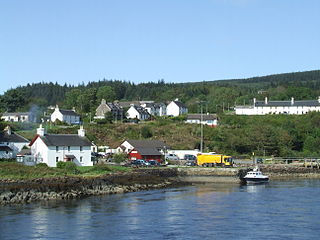
Talisker is a settlement on the Minginish peninsula in the Isle of Skye, Scotland.
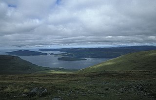
Loch na Keal, meaning Loch of the Kyle, or Narrows, also Loch of the Cliffs, is the principal sea loch on the western, or Atlantic coastline of the island of Mull, in the Inner Hebrides, Argyll and Bute, Scotland. Loch na Keal extends over 20 kilometres (12 mi) inland, almost bisecting Mull, and extending to within 5 km (3 mi) of the eastern shore. The loch gives its name to the Loch na Keal National Scenic Area, one of forty national scenic areas in Scotland.

Ardmeanach is a peninsula on the Isle of Mull. It is the middle one out of three westward-facing peninsulas on the island, and the name in Gaelic means "Middle Headland" or "Middle Height". It is about 20 km long and 6 km wide, and lies between Loch Scridain and Loch Na Keal.
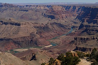
The Cardenas Basalt, also known as either the Cardenas Lava or Cardenas Lavas, is a rock formation that outcrops over an area of about 310 km2 (120 mi2) in the eastern Grand Canyon, Coconino County, Arizona. The lower part of the Cardenas Basalt forms granular talus slopes. Its upper part forms nearly continuous low cliffs that are parallel to the general course of the Colorado River. The most complete, readily accessible, and easily studied exposure of the Cardenas Basalt lies in Basalt Canyon. This is also its type locality.

Pennyghael is a small village in the Ross of Mull, Argyll and Bute, Scotland. It is located along the A849 road aligned along the coast line of Ross, on Loch Scridain in southwestern Mull, along the road to Bunessan. The Leidle River passes to the west of the village into the Loch.

Tiroran is hamlet on the Isle of Mull in Argyll and Bute, Scotland.
Loch Buie is a sea loch on the south coast of the Isle of Mull, off the west coast of Scotland. It takes the form of a deep bay opening onto the Firth of Lorn. At the head of the loch is the settlement of Lochbuie at the end of a minor road form the A849 at Ardura. There are a handful of small islands and rocky islets close to shore, the largest of which is Eilean Mor which is connected to the mainland of Mull at low tide. Nearby is Moy Castle. There are extensive shore platforms around the loch, notably on its southeastern side beneath Laggan Deer Forest.

The geology of the Isle of Mull in Scotland is dominated by the development during the early Palaeogene period of a ‘volcanic central complex’ associated with the opening of the Atlantic Ocean. The bedrock of the larger part of the island is formed by basalt lava flows ascribed to the Mull Lava Group erupted onto a succession of Mesozoic sedimentary rocks during the Palaeocene epoch. Precambrian and Palaeozoic rocks occur at the island's margins. A number of distinct deposits and features such as raised beaches were formed during the Quaternary period.
Loch Don is a sea loch on the east coast of the Isle of Mull, off the west coast of Scotland. It is an intricately shaped loch opening onto the Firth of Lorn near the easternmost point of Mull. Its waters are shallow and the loch dries almost completely at low tide. The community of Lochdon sits on the A849 at the head of the loch. A minor road runs south from Lochdon and around to Grass Point at the point where the loch meets the open waters of the firth. There are both a terminal moraine and deltaic sand deposits around the northern end of the loch, a product of meltwater flow at the end of the last ice age. The shores of the outer part of the loch are formed from basalt lava flows of Palaeogene age whilst the inner parts of the loch extend across Palaeozoic basalt and also Mesozoic sedimentary rocks including Triassic sandstones and Jurassic Lias strata.