Lochdon

Last updated

Lochdon
Lochdon Free Church of Scotland - geograph.org.uk - 876628.jpg
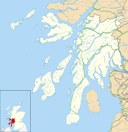
Argyll and Bute UK location map.svg
Red pog.svg
Lochdon
Location within Argyll and Bute
OS grid reference NM728333
Community council
Council area
Lieutenancy area
Country Scotland
Sovereign state United Kingdom
Post town ISLE OF MULL
Postcode district PA64 6
Dialling code 01680
Police Scotland
Fire Scottish
Ambulance Scottish
UK Parliament
Scottish Parliament
List of places
UK
Scotland
56°26′10″N5°41′15″W / 56.436117°N 5.687538°W / 56.436117; -5.687538

Lochdon or Lochdonhead (Scottish Gaelic : Loch Dona or Scottish Gaelic : Cheann Loch Dona) is a small village on the Isle of Mull, in the council area of Argyll and Bute, off the west coast of Scotland. The village is within the parish of Torosay, just south of Craignure on the A849 at the head of Loch Don. [1] The name Lochdonhead means "The head of the bad loch". [2]

The Lochdon Free Church is located in the town.
Related Research Articles

<span class="mw-page-title-main">Argyll and Bute</span> Council area of Scotland

Argyll and Bute is one of 32 unitary council areas in Scotland and a lieutenancy area. The current lord-lieutenant for Argyll and Bute is Jane Margaret MacLeod. The administrative centre for the council area is in Lochgilphead at Kilmory Castle, a 19th-century Gothic Revival building and estate. The current council leader is Councillor Jim Lynch.

<span class="mw-page-title-main">Tobermory, Mull</span> Village on the Isle of Mull, Scotland

Tobermory is the capital of, and until 1973 the only burgh on, the Isle of Mull in the Scottish Inner Hebrides. It is located on the east coast of Mishnish, the most northerly part of the island, near the northern entrance of the Sound of Mull. The village was founded as a fishing port in 1788; its layout was based on the designs of Dumfriesshire engineer Thomas Telford. As of 2022 its population was 1,045. It is notable as the location for the 2002–05 children's programme Balamory by the BBC.

<span class="mw-page-title-main">Isle of Mull</span> Island off the coast of Scotland

The Isle of Mull or simply Mull is the second-largest island of the Inner Hebrides and lies off the west coast of Scotland in the council area of Argyll and Bute.

<span class="mw-page-title-main">Argyll</span> Historic county and registration county of western Scotland

Argyll, sometimes called Argyllshire, is a historic county and registration county of western Scotland. The county ceased to be used for local government purposes in 1975 and most of the area now forms part of the larger Argyll and Bute council area.

<span class="mw-page-title-main">Isle of Mull Railway</span> Former railway line in Scotland

The Isle of Mull Railway was a 10+14 in gauge line, 1+14 miles (2.0 km) long, which ran from the ferry terminal at Craignure to Torosay Castle, on the Isle of Mull in the Scottish Inner Hebrides. Originally it was known as the Mull and West Highland Railway. The line was marketed as Scotland's original island passenger railway. The line opened in 1983 and closed in October 2010. A limited service operated over the 2011 Easter holiday and during summer 2011. The company's lease expired in October 2011. The track was lifted in October 2012.

<span class="mw-page-title-main">Bunessan</span> Human settlement in Scotland

Bunessan, meaning "bottom of the waterfall", is a small village on the Ross of Mull, a peninsula in the south-west of the Isle of Mull, off the west coast of Scotland. The settlement is at OS grid reference NM382218, within the parish of Kilfinichen and Kilvickeon, and is situated on the A849, at the head of a cove at the southern end of Loch na Làthaich.

<span class="mw-page-title-main">Knockan</span> Settlement on the Isle of Mull, Scotland

Knockan is a township of six crofts in the community of Ardtun, in the south of the Isle of Mull off the west coast of Scotland.

<span class="mw-page-title-main">Lochbuie, Mull</span> Human settlement in Scotland

Lochbuie is a settlement on the Isle of Mull in Scotland about 22 kilometres (14 mi) west of Craignure.

<span class="mw-page-title-main">Craignure</span> Ferry port on Isle of Mull, Scotland

Craignure is a village and the main ferry port on the Isle of Mull, Argyll and Bute, Scotland. The village is within the parish of Torosay.

MV <i>Lord of the Isles</i> Scottish ferry launched 1989

MV Lord of the Isles is one of the larger Caledonian MacBrayne vessels, and operates from Mallaig on the west of Scotland. Built in Port Glasgow, she is the most-travelled vessel in the CalMac fleet.

MV <i>Isle of Mull</i>

MV Isle of Mull is one of the larger ferries operated by Caledonian MacBrayne from Oban on the west of Scotland.

Crerar Hotel Group Ltd is a hotel chain and private limited company, based in Edinburgh, Scotland. It was founded as North British Trust Hotels Ltd in December 1902 and changed its name to Crerar Hotel Group in January 2012.

<span class="mw-page-title-main">Lochaline</span> Main village in the Morvern area of Highland, Scotland.

Lochaline is the main village in the Morvern area of Highland, Scotland. The coastal village is situated at the mouth of Loch Aline, on the northern shore of the Sound of Mull. A ferry operates regularly over to Fishnish on the Isle of Mull.

<span class="mw-page-title-main">Salen, Mull</span> Human settlement in Scotland

Salen is a settlement on the Isle of Mull, Scotland. It is on the east coast of the island, on the Sound of Mull, approximately halfway between Craignure and Tobermory at the narrowest part of the island. The full name of the settlement is 'Sàilean Dubh Chaluim Chille'. In 1991 it had a population of 500.

MV <i>Coruisk</i>

MV Coruisk is a Caledonian Maritime Assets Limited ferry built in 2003, operated by Scottish ferry operator Caledonian MacBrayne and serving the west coast of Scotland.

<span class="mw-page-title-main">Dervaig</span> Human settlement in Scotland

Dervaig is a small village on the Isle of Mull off the west coast of Scotland. The village is within the parish of Kilninian and Kilmore, and is situated on the B8073 roughly midway between Tobermory and Calgary. In 1961 it had a population of 82.

<span class="mw-page-title-main">Pennyghael</span> Human settlement in Scotland

Pennyghael is a small village in the Ross of Mull, Argyll and Bute, Scotland. It is located along the A849 road aligned along the coast line of Ross, on Loch Scridain in southwestern Mull, along the road to Bunessan. The Leidle River passes to the west of the village into the Loch.

Loch Don is a sea loch on the east coast of the Isle of Mull, off the west coast of Scotland. It is an intricately shaped loch opening onto the Firth of Lorn near the easternmost point of Mull. Its waters are shallow and the loch dries almost completely at low tide. The community of Lochdon sits on the A849 at the head of the loch. A minor road runs south from Lochdon and around to Grass Point at the point where the loch meets the open waters of the firth. There are both a terminal moraine and deltaic sand deposits around the northern end of the loch, a product of meltwater flow at the end of the last ice age. The shores of the outer part of the loch are formed from basalt lava flows of Palaeogene age whilst the inner parts of the loch extend across Palaeozoic basalt and also Mesozoic sedimentary rocks including Triassic sandstones and Jurassic Lias strata.

MV <i>Loch Frisa</i> Car/passenger ferry launched 2014

MV Loch Frisa is a ferry bought by Caledonian Maritime Assets for operation by Caledonian MacBrayne to serve between Oban and Craignure. She was originally named MV Utne and operated by Norled from 2015 to 2021. In December 2021, following a naming competition, CMAL announced her renaming as MV Loch Frisa.

<span class="mw-page-title-main">Torosay</span> Civil parish on Isle of Mull, Scotland

Torosay is a civil parish on the Isle of Mull in the county of Argyll, Scotland, part of the Argyll and Bute council area. It is one of three parishes on the island and extends over the central and south-eastern part. It is bordered by the parish of Kilninian and Kilmore in the north and Kilfinichen and Kilvickeon in the south-west. It extends about 12 miles east-west and 10 miles north-south. On the north-east coast it is separated from the mainland by the Sound of Mull. On its south-east coast, part of it is almost severed from the rest of the parish by the sea lochs Spelve and Buie, together with the freshwater loch Uisg, in between. This peninsula, which includes the hamlet of Croggan, is joined to the main island by a small isthmus at Kinlochspelvie and another at the settlement of Lochbuie. There is a smaller sea loch Loch Don, which gives its name to the hamlet of Lochdon. Further north, there is a bay at Craignure which is the location of a ferry port.

References

  1. "Craignure & Lochdon". Isle of Mull website. Retrieved 21 January 2024.
  2. "Placenames K-O" (PDF). Scottish Parliament. Retrieved 21 January 2024.