This article needs additional citations for verification .(June 2022) |
Knockan
| |
---|---|
Coastal scene, looking towards Loch Scridain | |
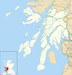
Location within Argyll and Bute | |
OS grid reference | NM4023 |
Council area | |
Lieutenancy area | |
Country | Scotland |
Sovereign state | United Kingdom |
Post town | ISLE OF MULL |
Postcode district | PA67 |
Police | Scotland |
Fire | Scottish |
Ambulance | Scottish |
UK Parliament | |
Scottish Parliament | |
Knockan (Scottish Gaelic : An Cnocan) is a township of six crofts in the community of Ardtun, in the south of the Isle of Mull off the west coast of Scotland.
Cnocan in Gaelic means "little hill". The cottage called "Knockan" is distinguished by its bright red roof and white walls, set by a small hill. It is around 200 years old and was originally built by a weaver of the local crofting community. It is now owned by his descendants, the family of Donald Black. The other crofting cottages in the "township" of Knockan include "Knockan House" and "Rhudda na Cruban"
Knockan is situated on an unclassified road, north of its junction with the A849. [1] The A849 is the main route across southern Mull, travelling from Salen to Fionnphort, via Craignure. [2]
Eriskay, from the Old Norse for "Eric's Isle", is an island and community council area of the Outer Hebrides in northern Scotland with a population of 143, as of the 2011 census. It lies between South Uist and Barra and is connected to South Uist by a causeway which was opened in 2001. In the same year Ceann a' Ghàraidh in Eriskay became the ferry terminal for travelling between South Uist and Barra. The Caledonian MacBrayne vehicular ferry travels between Eriskay and Ardmore in Barra. The crossing takes around 40 minutes.
Bunessan, meaning "bottom of the waterfall", is a small village on the Ross of Mull, a peninsula in the south-west of the Isle of Mull, off the west coast of Scotland. The settlement is at OS grid reference NM382218, within the parish of Kilfinichen and Kilvickeon, and is situated on the A849, at the head of a cove at the southern end of Loch na Làthaich.
Crofting is a form of land tenure and small-scale food production peculiar to the Scottish Highlands, the islands of Scotland, and formerly on the Isle of Man. Within the 19th-century townships, individual crofts were established on the better land, and a large area of poorer-quality hill ground was shared by all the crofters of the township for grazing of their livestock. In the 21st century, crofting is found predominantly in the rural Western and Northern Isles and in the coastal fringes of the western and northern Scottish mainland.
Craignure is a village and the main ferry port on the Isle of Mull, Argyll and Bute, Scotland. The village is within the parish of Torosay.
Garenin is a crofting township on the west coast of the Isle of Lewis in the Outer Hebrides of Scotland. Garenin is in the Carloway municipality and has a population of about 80 people. It is also within the parish of Uig. Today, the village is most famous for the "blackhouse village", which consists of nine restored traditional thatched cottages. The village is found at the end of the Garenin road beside the village bay. These houses were lived in until 1974 and were the last group of blackhouses to be inhabited in the Western Isles. Piped water was not available in the village until the 1960s.
Assynt is a sparsely populated area in the south-west of Sutherland, lying north of Ullapool on the west coast of Scotland. Assynt is known for its landscape and its remarkable mountains, which have led to the area, along with neighbouring Coigach, being designated as the Assynt-Coigach National Scenic Area, one of 40 such areas in Scotland.
Auchlyne is a small hamlet in Stirling, Scotland. It is located approximately five miles west of Killin on Loch Tay, off the main A85 road that runs from Perth to Oban.
Fearnan is a small crofting village on the north shore of Loch Tay in Perthshire, Scotland.
Tarskavaig is a crofting village on the west coast of Sleat on the Isle of Skye in Scotland. It sits in a glen which meets Tarskavaig Bay and lies opposite the Isles of Eigg, Rum and Canna. It is often said that Tarskavaig has the best view of the Cuillin in Skye.
Knocknafenaig is a ruined township on the Isle of Mull, Scotland.
Ardtun is a settlement on the Isle of Mull, in Argyll and Bute, Scotland. Ardtun is within the parish of Kilfinichen and Kilvickeon.
The Ross of Mull is the largest peninsula of the Isle of Mull, about 28 kilometres (17 mi) long, and makes up the south-western part of the island. It is bounded to the north by Loch Scridain and to the south by the Firth of Lorne. The main villages are Bunessan and Fionnphort, with smaller settlements including Ardtun, Camas, Carsaig, Knockan, Pennyghael and Uisken. Knocknafenaig, Suidhe, and Shiaba are three of the many cleared settlements on the Ross.
Cromore is a crofting township on the Isle of Lewis in the district of Pairc, in the Outer Hebrides, Scotland. The settlement is within the parish of Lochs. Cromore is about 27 miles away by road from Stornoway, the nearest town.
Elphin is a crofting township in Assynt, in the Sutherland area of Highland in Scotland. It lies about 15 miles north of Ullapool. The village contains a telephone box, a post box, a tearoom, a Scottish Mountaineering Club Hut, Grampian Speleological Group Hut, a small caravan site and many self-catering options. Assynt Primary School closed in 2001, and the building is now a community hall operated by Elphin Ledmore and Knockan Community Association Limited. The township now has its own website, see external links.
Camuscross is a small crofting township on the Isle of Skye in Scotland.
Drumfearn is a small crofting township, lying at the head of the Sleat peninsula, at the head of Loch Eishort, on the isle of Skye in the Highalnds of Scotland and is in the Scottish council area of Highland.
Eilean Fladday is a previously populated tidal island off Raasay, near the Isle of Skye, Scotland.
Loch na Keal, meaning Loch of the Kyle, or Narrows, also Loch of the Cliffs, is the principal sea loch on the western, or Atlantic coastline of the island of Mull, in the Inner Hebrides, Argyll and Bute, Scotland. Loch na Keal extends over 20 kilometres (12 mi) inland, almost bisecting Mull, and extending to within 5 km (3 mi) of the eastern shore. The loch gives its name to the Loch na Keal National Scenic Area, one of forty national scenic areas in Scotland.
Pennyghael is a small village in the Ross of Mull, Argyll and Bute, Scotland. It is located along the A849 road aligned along the coast line of Ross, on Loch Scridain in southwestern Mull, along the road to Bunessan. The Leidle River passes to the west of the village into the Loch.
Shiaba is a ruined township located on the southwestern peninsula of the Isle of Mull, Scotland. It lies about 8 km to the east of the village of Bunessan, beyond Loch Assapol and Scoor House. It was awarded the status of Scheduled monument in 1993 due to its significance as a source of information about 18th and 19th century rural life in Scotland.