Bunessan

Last updated

Bunessan
Bunessan.JPG
Bunessan village viewed from the road to Fionnphort
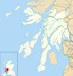
Argyll and Bute UK location map.svg
Red pog.svg
Bunessan
Location within Argyll and Bute
Population107 (1961)
OS grid reference NM381217
Civil parish
  • Kilfinichen and Kilvickeon
Council area
Lieutenancy area
Country Scotland
Sovereign state United Kingdom
Post town ISLE OF MULL
Postcode district PA67
Dialling code 01681
Police Scotland
Fire Scottish
Ambulance Scottish
UK Parliament
Scottish Parliament
Bunessan Lighthouse
Eileanan Liathanaitch
Gray Islands OOjs UI icon edit-ltr-progressive.svg
Na Liathanaich's diminutive lighthouse (geograph 5796173) (cropped).jpg
Coordinates 56°20′34″N6°16′22″W / 56.342770°N 6.272858°W / 56.342770; -6.272858
Constructed1901 (first)
Constructionmetal skeletal tower
Automated2001
Height5 metres (16 ft)
Shapequadrangular tower with aluminium panels as daymark
Markingswhite tower
OperatorNorthern Lighthouse Board [1]
First lit2001 (current)
Deactivated2001 (first)
Focal height12 metres (39 ft)
Range8 nmi (15 km; 9.2 mi) (white), 6 nmi (11 km; 6.9 mi) (red)  OOjs UI icon edit-ltr-progressive.svg
Characteristic Fl WR 6s.
List of places
UK
Scotland
56°18′58″N6°14′06″W / 56.316°N 6.235°W / 56.316; -6.235

Bunessan (Scottish Gaelic : Bun Easain), meaning "bottom of the waterfall", [2] is a small village on the Ross of Mull, a peninsula in the south-west of the Isle of Mull, off the west coast of Scotland. The settlement is at OS grid reference NM382218, [3] within the parish of Kilfinichen and Kilvickeon, [4] and is situated on the A849, [5] at the head of a cove at the southern end of Loch na Làthaich.
Contents

Community

In 1961[ needs update ] it had a population of 107. [4] A village hall is used for dances throughout the year. The primary school for the Ross of Mull is found in Bunessan.

Economy

Business has included crofting, a mill (now home to the Ross of Mull Historical Centre), weaving and a small fishing fleet, up to the end of the 20th century. The village still has a lobster fishery. [6]

Bunessan village has one hotel, The Bunessan Inn (previously named Argyll Arms) (the only pub in the area), one grocery shop and a craft shop.

Bunessan Inn

The Bunessan Inn, previously the Argyll Arms, is the only pub and hotel in the village of Bunessan in Argyll and Bute.

It was established over three centuries ago (the exact date is unknown). The earliest record of the inn was in 1773 when Dr Samuel Johnson and James Boswell, on their way to the isle of Iona, stopped at the inn in search of whisky from Lachlan McLean; but upon asking the innkeeper they found that the whisky supplies were empty due to a funeral a few days before. [7] [ better source needed ]

The Inn was reopened in June 2023 under new ownership following a cellar refurbishment and installation of new toilet and baby change facilities. the guest rooms are set to reopen from Easter of 2024. [7]

Hymn tune

Mary Macdonald (Màiri Dhòmhnallach) from the nearby crofting community of Ardtun used a traditional local melody for her Scottish Gaelic Christmas carol titled Leanabh an Àigh. In the 1880s Lachlan Macbean translated the text as "Child in the Manger" and called the air "Bunessan". The tune was reused in the 1930s for the hymn "Morning Has Broken".

Lighthouse

Bunessan lighthouse is located on a skerry of Gray Island in the entrance to Loch na Làthaich and the harbour of Bunessan. The present lighthouse is a metal skeletal tower covered by white aluminium panel as a daymark and the light on the top. The light emits a white or red flash, depending on the direction every six seconds.

See also

Related Research Articles

Lismore is an island of some 2,351 hectares in the Inner Hebrides of Scotland. The climate is damp and mild, with over 166 centimetres (65 in) of rain recorded annually. This fertile, low-lying island was once a major centre of Celtic Christianity, with a 6th-century monastery associated with Saint Moluag, and later became the seat of the medieval Bishop of Argyll. There are numerous ruined structures, including a broch and two 13th-century castles.

<span class="mw-page-title-main">Isle of Mull</span> Island off the coast of Scotland

The Isle of Mull or simply Mull is the second-largest island of the Inner Hebrides and lies off the west coast of Scotland in the council area of Argyll and Bute.

<span class="mw-page-title-main">Argyll</span> Historic county and registration county of western Scotland

Argyll, sometimes called Argyllshire, is a historic county and registration county of western Scotland. The county ceased to be used for local government purposes in 1975 and most of the area now forms part of the larger Argyll and Bute council area.

<span class="mw-page-title-main">Cowal</span> Peninsula in Argyll and Bute, Scotland

Cowal is a rugged peninsula in Argyll and Bute, on the west coast of Scotland. It is connected to the mainland to the north, and is bounded by Loch Fyne to the west, by Loch Long and the Firth of Clyde to the east, and by the Kyles of Bute to the south.

<span class="mw-page-title-main">Lagavulin</span> Human settlement in Scotland

Lagavulin is a small village approximately 3 miles outside Port Ellen on the Isle of Islay, Scotland. The village is within the parish of Kildalton, and is situated on the A846 road.

<span class="mw-page-title-main">Port Bannatyne</span> Human settlement in Scotland

Port Bannatyne, is a coastal village on the Isle of Bute, Firth of Clyde, Scotland that is home to many steamers. Port Bannatyne developed into the 1900s as a quieter alternative to Rothesay. It is a popular harbour, with a small yacht marina and boatyard and an unusual 13-hole golf course rather than the standard 18.

<span class="mw-page-title-main">Sandbank, Argyll</span> Village in Scotland

Sandbank is a village on the Cowal peninsula in Argyll and Bute, Scotland. It is located 2.5 miles north of Dunoon on the coastal A815 or the inland A885. It sits on the southern shore of the Holy Loch, a sea loch of the Firth of Clyde.

<span class="mw-page-title-main">Craignure</span> Ferry port on Isle of Mull, Scotland

Craignure is a village and the main ferry port on the Isle of Mull, Argyll and Bute, Scotland. The village is within the parish of Torosay.

<span class="mw-page-title-main">Port Askaig</span> Human settlement in Scotland

Port Askaig is a port village on the east coast of the island of Islay, in Argyll and Bute, Scotland. The village lies on the Sound of Islay across from Jura.

<span class="mw-page-title-main">Connel</span> Human settlement in Scotland

Connel is a village in Argyll and Bute, Scotland. It is situated on the southern shore of Loch Etive. The Lusragan Burn flows through the village and into the loch.

<span class="mw-page-title-main">Aridhglas</span> Hamlet near Fionnphort on Isle of Mull, Scotland

Aridhglas is a village on the Ross of Mull, Isle of Mull in Argyll and Bute, Scotland. Creich Hall, Creich War memorial and Creich Church are located in or around the settlement. Aridhglass is one mile (1.6 km) east of Fionnphort on the road to Bunessan, at the junction with the road to Kintra.

<span class="mw-page-title-main">Salen, Mull</span> Human settlement in Scotland

Salen is a settlement on the Isle of Mull, Scotland. It is on the east coast of the island, on the Sound of Mull, approximately halfway between Craignure and Tobermory at the narrowest part of the island. The full name of the settlement is 'Sàilean Dubh Chaluim Chille'. In 1991 it had a population of 500.

<span class="mw-page-title-main">Sound of Mull</span> Sound between the Inner Hebridean island of Mull and mainland Scotland

The Sound of Mull is a sound between the Inner Hebridean island of Mull and mainland Scotland. It forms part of the Atlantic Ocean.

<span class="mw-page-title-main">Pennyghael</span> Human settlement in Scotland

Pennyghael is a small village in the Ross of Mull, Argyll and Bute, Scotland. It is located along the A849 road aligned along the coast line of Ross, on Loch Scridain in southwestern Mull, along the road to Bunessan. The Leidle River passes to the west of the village into the Loch.

<span class="mw-page-title-main">Shiaba</span> Human settlement in Scotland

Shiaba is a ruined township located on the southwestern peninsula of the Isle of Mull, Scotland. It lies about 8 km to the east of the village of Bunessan, beyond Loch Assapol and Scoor House. It was awarded the status of Scheduled monument in 1993 due to its significance as a source of information about 18th and 19th century rural life in Scotland.

Suidhe is a ruined township located on the southwestern peninsula of the Isle of Mull, Scotland. It lies about three-quarters mile (1.2 km) to the west of the village of Bunessan in the civil parish of Kilfinichen and Kilvickeon. It was awarded the status of Scheduled monument in 2004 on the basis of its potential value as a source of information about post-medieval, and possibly medieval, settlement and economy in the Western Isles of Scotland.

<span class="mw-page-title-main">Lochdon</span> Human settlement in Scotland

Lochdon or Lochdonhead is a small village on the Isle of Mull, in the council area of Argyll and Bute, off the west coast of Scotland. The village is within the parish of Torosay, just south of Craignure on the A849 at the head of Loch Don. The name Lochdonhead means "The head of the bad loch".

<span class="mw-page-title-main">Torosay</span> Civil parish on Isle of Mull, Scotland

Torosay is a civil parish on the Isle of Mull in the county of Argyll, Scotland, part of the Argyll and Bute council area. It is one of three parishes on the island and extends over the central and south-eastern part. It is bordered by the parish of Kilninian and Kilmore in the north and Kilfinichen and Kilvickeon in the south-west. It extends about 12 miles east-west and 10 miles north-south. On the north-east coast it is separated from the mainland by the Sound of Mull. On its south-east coast, part of it is almost severed from the rest of the parish by the sea lochs Spelve and Buie, together with the freshwater loch Uisg, in between. This peninsula, which includes the hamlet of Croggan, is joined to the main island by a small isthmus at Kinlochspelvie and another at the settlement of Lochbuie. There is a smaller sea loch Loch Don, which gives its name to the hamlet of Lochdon. Further north, there is a bay at Craignure which is the location of a ferry port.

<span class="mw-page-title-main">Kilfinichen and Kilvickeon</span> Civil parish on Isle of Mull, Scotland

Kilfinichen and Kilvickeon is a civil parish on the Isle of Mull in the county of Argyll, Scotland, part of the Argyll and Bute council area. It is one of three parishes on the island and extends over the south-western part and includes the islands of Iona, Erraid and Inch Kenneth. It is bordered by the parish of Torosay in the north and east. It extends about 23 miles north-east to south-west and is 18 miles wide.

References

  1. Rowlett, Russ. "Lighthouses of Scotland: Argyll and Bute". The Lighthouse Directory. University of North Carolina at Chapel Hill . Retrieved 22 May 2016.
  2. Scottish Parliament
  3. "ARGYLL ARMS HOTEL BUNESSAN (LB12306)". portal.historicenvironment.scot. Retrieved 20 February 2024.
  4. 1 2 "Details of Bunessan". Scottish Places. Retrieved 31 December 2014.
  5. "A849". Sabre. Retrieved 31 December 2014.
  6. "Bunessan: Argyll and Bute". Gazetteer for Scotland. Retrieved 8 December 2020.
  7. 1 2 "Bunessan Inn - Good Food and Drink in Bunessan, Isle of Mull". Bunessan Inn. Retrieved 20 February 2024.