Oldany Island

Last updated

Oldany Island
Meaning of namefruit
Location
Sutherland UK relief location map.jpg
Red pog.svg
Oldany Island
Oldany Island shown within Scotland
OS grid reference NC088345
Coordinates 58°16′N5°16′W / 58.26°N 5.26°W / 58.26; -5.26
Physical geography
Island group Highland / Islands of Sutherland
Area200 ha [1]
Area rank109 [2]
Highest elevationSidhean nan Ealachan 104 m
Administration
Council area Highland Council
Country Scotland
Sovereign state United Kingdom
Demographics
Population0
Lymphad3.svg
References [1] [3] [4] [5]

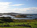
Oldany Island (formerly Oldney Island) is an uninhabited island in Assynt, Sutherland, north-west Scotland.

The name is Norse in origin and possibly means fruit. [6]

Geography

Oldany Island is a large tidal island at the southwestern entrance to Eddrachillis Bay/Kylesku. It has an area of 200 hectares (500 acres) and its highest point is Sìdhean nan Ealachan (The Swans' Fairy Mound) at 104 metres (341 ft). [1] Handa Island is to the north, across Eddrachillis Bay; Eilean Chrona is to the south west and Sgeir nan Gall (Norsemen's Skerry) is to the north. The island is part of the Assynt-Coigach National Scenic Area, one of 40 in Scotland. [7]

The settlement of Oldany is on the adjacent mainland. The island has long been used for grazing sheep. Oldany island is owned by the Turner family. [8]

Notes and references

  1. 1 2 3 "Overview of Oldany". Gazetteer for Scotland. Retrieved 14 December 2007.
  2. Area and population ranks: there are c.300 islands over 20ha in extent. 93 permanently inhabited islands were listed in the 2011 census and 101 such islands in 2022.
  3. National Records of Scotland (15 August 2013). "Appendix 2: Population and households on Scotland's Inhabited Islands" (PDF). Statistical Bulletin: 2011 Census: First Results on Population and Household Estimates for Scotland Release 1C (Part Two) (PDF) (Report). SG/2013/126. Retrieved 15 July 2025.
  4. Haswell-Smith, Hamish. (2004) The Scottish Islands. Edinburgh. Canongate.
  5. Ordnance Survey: Landranger map sheet 15 Loch Assynt (Lochinver & Kylesku) (Map). Ordnance Survey. 2012. ISBN   9780319231265.
  6. Place names Highlands & Islands of Scotland. Alex. Macbain. 1922. ISBN   9785878525244 . Retrieved 26 October 2018.{{cite book}}: ISBN / Date incompatibility (help)
  7. "National Scenic Areas" Archived 2017-03-11 at the Wayback Machine . SNH. Retrieved 30 Mar 2011.
  8. "Property Page:Oldany". Who owns Scotland. Retrieved 21 January 2008.[ dead link ] Alt URL [ dead link ]

58°15.5′N5°15.5′W / 58.2583°N 5.2583°W / 58.2583; -5.2583