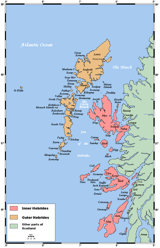
The Outer Hebrides or Western Isles, sometimes known as the Long Isle or Long Island, is an island chain off the west coast of mainland Scotland. The islands form part of the archipelago of the Hebrides, separated from the Scottish mainland and from the Inner Hebrides by the waters of the Minch, the Little Minch, and the Sea of the Hebrides. The Outer Hebrides are considered to be the traditional heartland of the Gaelic language. The islands form one of the 32 council areas of Scotland, which since 1998 has used only the Gaelic form of its name, including in English language contexts. The council area is called Na h-Eileanan an Iar and its council is Comhairle nan Eilean Siar.
Grimsay is a tidal island in the Outer Hebrides of Scotland.
Berneray is an island and community in the Sound of Harris, Scotland. It is one of fifteen inhabited islands in the Outer Hebrides. It is famed for its rich and colourful history which has attracted much tourism. It lies within the South Lewis, Harris and North Uist National Scenic Area, one of 40 such areas in Scotland which are defined so as to identify areas of exceptional scenery and to ensure its protection from inappropriate development.

Pabbay is one of the Barra Isles at the southern tip of the Outer Hebrides of Scotland. The name comes from Papey, which is Norse for "island of the papar". At only 250 hectares (1 sq mi), it never had a large population, and, after all the able-bodied men were killed in a fierce storm while out on a fishing trip on 1 May 1897, it was abandoned in the early twentieth century.
Soay is an uninhabited islet in the St Kilda archipelago, Scotland. The name is from Old Norse Sauðey, meaning "island of sheep". The island is part of the St Kilda World Heritage Site and home to a primitive breed of sheep. Excluding Rockall, it is the westernmost point of the United Kingdom.
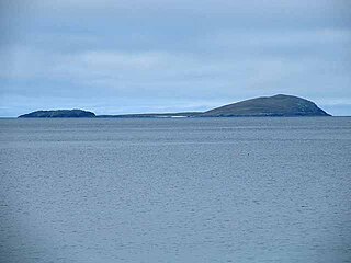
Shillay is an uninhabited island which lies 2 km north of Pabbay in the Outer Hebrides of Scotland.
Ceann Ear is the largest island in the Monach or Heisgeir group off North Uist in north west Scotland. It is 203 hectares in size and connected by sandbanks to Ceann Iar via Sibhinis at low tide. It is said that it was at one time possible to walk all the way to Baleshare, and on to North Uist, 5 miles away at low tide. In the 16th century, a large tidal wave was said to have washed this away.
Ceann Iar is one of the Monach Isles/Heisgeir, to the west of North Uist in the Outer Hebrides. It is a slender island, approximately a mile, or two kilometres long.
Hermetray is an uninhabited island off North Uist, in the Outer Hebrides of Scotland.
The flora and fauna of the Outer Hebrides in northwest Scotland comprises a unique and diverse ecosystem. A long archipelago, set on the eastern shores of the Atlantic Ocean, it attracts a wide variety of seabirds, and thanks to the Gulf Stream a climate more mild than might be expected at this latitude. Because it is on the Gulf Stream, it also occasionally gets exotic visitors.
Ceallasaigh Mòr is a low-lying island in Loch Maddy off North Uist in the Outer Hebrides of Scotland. This an area of shallow lagoons filled and drained by the tides each day. Ceallasaigh Beag lies to the south and these two islets are connected by a narrow strip of sand at low tide. Ceallasaigh Mòr may also join mainland North Uist near Bràigh Cheallasaigh at some stages of the tide.

Stac Levenish or Stac Leibhinis is a sea stack in the St Kilda archipelago in Scotland. Lying 2.5 kilometres off Village Bay on Hirta, it is part of the rim of an extinct volcano that includes Dùn, Ruaival and Mullach Sgar.

Boreray is an uninhabited island in the St Kilda archipelago in the North Atlantic.
Stromay is a tidal island off North Uist in the Sound of Harris, Scotland.
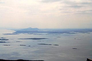
The Sound of Harris is a channel between the islands of Harris and North Uist in the Outer Hebrides of Scotland.

Fraoch-eilean is a small island with an uncertain population north of Benbecula in the Outer Hebrides of Scotland. It is about 55 hectares in extent and the highest point is 11 metres (36 ft). Its name derives from the Gaelic for "heather island".

South Lewis, Harris and North Uist is a large national scenic area (NSA) in the Western Isles of Scotland. It is one of 40 such areas in Scotland, which are defined so as to identify areas of exceptional scenery and to ensure its protection from inappropriate development. The designated area covers 202,388 ha in total, of which 112,301 ha is on land, with a further 90,087 ha being marine, making it the largest of the NSAs in both total and marine area. The designated area includes the mountainous south west of Lewis, all of Harris, the Sound of Harris and the northern part of North Uist.

Ceallasaigh Beag is a low-lying island in Loch Maddy off North Uist in the Outer Hebrides of Scotland. This an area of shallow lagoons filled and drained by the tides each day. Ceallasaigh Mòr lies to the south and these two islets are connected by a narrow strip of sand during some low tides.
This page is based on this
Wikipedia article Text is available under the
CC BY-SA 4.0 license; additional terms may apply.
Images, videos and audio are available under their respective licenses.


