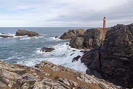
The Butt of Lewis (Scottish Gaelic : Rubha Robhanais) is the most northerly point of Lewis in the Outer Hebrides. The headland, which lies in the North Atlantic, is frequently battered by heavy swells and storms and is marked by the Butt of Lewis Lighthouse. The nearest populated area is the village of Eoropie, about 1 mile (1.5 kilometres) to the south. [1] [2]
The road to the lighthouse passes a sheltered cove called Port Stoth. Southwest from the lighthouse is a natural arch called the "Eye of the Butt" (Scottish Gaelic : Sùil an Rubha).
It is claimed that the Butt of Lewis is one of the windiest locations in the United Kingdom. [3] [4]
The Butt of Lewis Lighthouse was built by the famous lighthouse builder David Stevenson in 1862. [5] Other sources include Thomas Stevenson as one of the builders too. [6] Little is known of the station's early history. A plaque in the lightroom indicates that the present equipment was installed in 1905. The station became the radio link for the keepers on the isolated Flannan Islands in the early 1930s, and continued to function as such until 1971, when the Flannans was made automatic. [5]
The light was most-likely fuelled by fish oil in the beginning. This was then replaced by a paraffin burner in 1869 and finally by electricity in 1976. [5]
It was operated by three Keepers who lived at the Station with their families but the fog signal was discontinued on 31 March 1995 and the light was automated on 30 March 1998. It is now remotely monitored from Edinburgh. [5]
Until the early 1960s, all supplies were delivered by sea because of the poor road system on the island. This would occur at the nearby Port Stoth, where small cargo vessels would regularly berth if the weather allowed it to offload provisions for the lighthouse station. [4]
The Butt of Lewis was also one the General Lighthouse Authorities transmitting stations for Differential GPS until March 2022. [5]
One kilometre south-west of the Butt is a stack, or small island, of Eilean nan Luchruban, also known as the Pygmies' Isle. The isle was first mentioned by Dean Munro in about 1549 and described as being a ‘kirk’ where pygmies were buried. There are several structures on the island and earlier historical records mention bones in the structures. [7] It was excavated by antiquarians sometime before 1905, when bones and pottery were found. The bones were found to be from animals [7] and the pottery was later found to be from the Neolithic period. [8]
RCAHMS surveyed the isle in 1928 and found part of the structures had collapsed since the excavations. [9] A survey in 2005 found some additional structures not mentioned by the earlier sources. [10]
The name is derived from Lusbirdan/Luspardan which, in both Gaelic and Scots, means "pigmy". It is thought that it is derived from Lug/i-npiorad, which means "little spirit". In Blaeu's map, the name of the isle is Ylen Dunibeg ("Island of the Little Men"). [7]
The Hebrides are an archipelago off the west coast of the Scottish mainland. The islands fall into two main groups, based on their proximity to the mainland: the Inner and Outer Hebrides.
The Outer Hebrides or Western Isles, sometimes known as the Long Isle/Long Island, is an island chain off the west coast of mainland Scotland. The islands are geographically coextensive with Comhairle nan Eilean Siar, one of the 32 unitary council areas of Scotland. They form part of the archipelago of the Hebrides, separated from the Scottish mainland and from the Inner Hebrides by the waters of the Minch, the Little Minch, and the Sea of the Hebrides. Scottish Gaelic is the predominant spoken language, although in a few areas English speakers form a majority.
The Isle of Lewis or simply Lewis is the northern part of Lewis and Harris, the largest island of the Western Isles or Outer Hebrides archipelago in Scotland. The two parts are frequently referred to as if they were separate islands. The total area of Lewis is 683 square miles (1,770 km2).
The Inner Hebrides is an archipelago off the west coast of mainland Scotland, to the south east of the Outer Hebrides. Together these two island chains form the Hebrides, which experience a mild oceanic climate. The Inner Hebrides comprise 35 inhabited islands as well as 44 uninhabited islands with an area greater than 30 hectares. Skye, Mull, and Islay are the three largest, and also have the highest populations. The main commercial activities are tourism, crofting, fishing and whisky distilling. In modern times the Inner Hebrides have formed part of two separate local government jurisdictions, one to the north and the other to the south. Together, the islands have an area of about 4,130 km2 (1,594 sq mi), and had a population of 18,948 in 2011. The population density is therefore about 4.6 inhabitants per square kilometre.
Barra Head, also known as Berneray, is the southernmost island of the Outer Hebrides in Scotland. Within the Outer Hebrides, it forms part of the Barra Isles archipelago. Originally, Barra Head only referred to the southernmost headland of Berneray but is now a common name for the entire island. The highest point of the island is Sotan, a Marilyn.
The Flannan Isles or alternatively, the Seven Hunters are a small island group in the Outer Hebrides of Scotland, approximately 32 kilometres west of the Isle of Lewis. They may take their name from Saint Flannan, the 7th century Irish preacher and abbot.
Point, also known as the Eye Peninsula, is a peninsula some 11 km long in the Outer Hebrides, Scotland. The majority of Point is connected to the rest of the Isle of Lewis by a narrow isthmus, one mile in length and at one point barely 100 metres wide. The peninsula is just 6 km east of the regional capital of Stornoway, however the district of Point actually starts at the Parkend estate on Stornoway's outskirts. Point is home to around 2,600 people and is one of the few districts of the Western Isles where the population is increasing. There are about 17 villages and hamlets in Point: Melbost (Mealabost), Branahuie, Aignish (Aiginis), Knock, Swordale (Suardail), Garrabost, Lower Bayble, Eagleton, Upper Bayble, Shulishader, Sheshader (Seisiader), Flesherin (Fleisirin), Cnoc Amhlaigh, Portnaguran, Aird, Broker (Brocair), and Portvoller.
The Minch, also called North Minch, is a strait in north-west Scotland, separating the north-west Highlands and the northern Inner Hebrides from Lewis and Harris in the Outer Hebrides. It was known as Skotlandsfjörð in Old Norse.
Bragar is a village on the west side of the Isle of Lewis in the Outer Hebrides, Scotland, 14 miles from the island's only town, Stornoway. Bragar is within the parish of Barvas, and is situated on the A858 between Carloway and Barvas.
Ross-shire is a historic county in the Scottish Highlands. The county borders Sutherland to the north and Inverness-shire to the south, as well as having a complex border with Cromartyshire – a county consisting of numerous enclaves or exclaves scattered throughout Ross-shire's territory. Ross-shire includes most of Ross along with Lewis in the Outer Hebrides. Dingwall is the traditional county town. The area of Ross-shire is based on that of the historic province of Ross, but with the exclusion of the many enclaves that form Cromartyshire.
The Hebrides were settled early on in the settlement of the British Isles, perhaps as early as the Mesolithic era, around 8500–8250 BC, after the climatic conditions improved enough to sustain human settlement. There are examples of structures possibly dating from up to 3000 BC, the finest example being the standing stones at Callanish, but some archaeologists date the site as Bronze Age. Little is known of the people who settled in the Hebrides but they were likely of the same Celtic stock that had settled in the rest of Scotland. Settlements at Northton, Harris, have both Beaker & Neolithic dwelling houses, the oldest in the Western Isles, attesting to the settlement.
North Dell is a village on the Isle of Lewis in the community of Ness, in the Outer Hebrides, Scotland. North Dell is within the parish of Barvas. It lies 5 km south of the Butt of Lewis, between the settlements of South Dell and Cross and comprises 22 crofts. North Dell is reputed to be the best village for the growing of potatoes in Lewis – along with Garrabost in Point!
Stac Dhòmnuill Chaim, or Stac Dhòmhnaill Chaim, or Stac Domhnuill Chaim, is a fortified promontory located near Mangursta on the Isle of Lewis in the Outer Hebrides of Scotland. The stack and its surrounding site is listed and protected as a scheduled monument. The site of the stack is located at grid reference NB00223152. The site is named after Donald Cam Macaulay, the early 17th century hero of the Macaulays of Uig. The site was documented in the late 19th century, but today it is considered inaccessible. In 2003 and 2006, an archaeological team of rock climbers scaled the promontory and documented the site; finding in 2006 a piece of possibly Neolithic pottery.
Port Stoth, known locally as Stoth and pronounced Stow, is a sheltered inlet just southeast of the Butt of Lewis in the Outer Hebrides, Scotland. It is the most northerly landing in the Outer Hebrides. A track leads down to a slipway which runs across the sandy beach.
Butt of Lewis Lighthouse, designed by David Stevenson, was built at Butt of Lewis to aid shipping in the 1860s. Unusual for a lighthouse in Scotland, it is constructed of red brick, and is unpainted. The station was automated in 1998, one of the last to be converted. A modern differential GPS base station has now been sited on a nearby hill to further aid navigation. This hill was also the site for a Lloyd's Signal Station from the 1890s.
Flannan Isles Lighthouse is a lighthouse near the highest point on Eilean Mòr, one of the Flannan Isles in the Outer Hebrides off the west coast of Scotland. It is best known for the mysterious disappearance of its keepers in 1900.
Rubha nan Gall lighthouse is located north of Tobermory on the Isle of Mull beside the Sound of Mull. The name means "Stranger's Point" in Scottish Gaelic. It was built in 1857 by David and Thomas Stevenson and is operated by the Northern Lighthouse Board. The lighthouse was automated in 1960 and the nearby former keepers' cottages are privately owned.