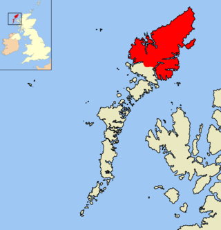
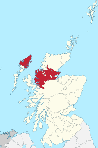
The Isle of Lewis or simply Lewis is the northern part of Lewis and Harris, the largest island of the Western Isles or Outer Hebrides archipelago in Scotland. The two parts are frequently referred to as if they were separate islands. The total area of Lewis is 683 square miles (1,770 km2).

Ross and Cromarty, is an area in the Highlands and Islands of Scotland. In modern usage, it is a registration county and a lieutenancy area. Between 1889 and 1975 it was a county.
Sleat is a peninsula and civil parish on the island of Skye in the Highland council area of Scotland, known as "the garden of Skye". It is the home of the clan MacDonald of Sleat. The name comes from the Scottish Gaelic Slèite, which in turn comes from Old Norse sléttr, which well describes Sleat when considered in the surrounding context of the mainland, Skye and Rùm mountains that dominate the horizon all about Sleat.
Knock, from the Gaelic, An Cnoc, is a village in Point peninsula on the Isle of Lewis in the Outer Hebrides of Scotland. Point is connected by road across a narrow isthmus to Stornoway, the main administrative centre of the Western Isles.

Portnaguran is a settlement situated within Point, on the Isle of Lewis, in the Outer Hebrides, Scotland. Portnaguran is the township at the north-easternmost point of the peninsula. It lies 1 mile (1.6 km) southwest of Tiumpan Head and just south of the headland called Geòdha 'ic Sheòrais or sometimes Small Head amongst locals. Portnaguran is situated at the north-eastern end of the A866, within the parish of Stornoway.

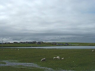
Aignish is located northwest of Knock and east of Stornoway on the east coast of the Isle of Lewis, in the Outer Hebrides, Scotland. The township is at the island side of the isthmus connecting to the Eye peninsula. Aignish is within the parish of Stornoway, and is situated on the A866 between Stornoway and Portnaguran.

Shawbost is a large village in the West Side of the Isle of Lewis. The village of Shawbost has a population of around 500 and lies around 20 miles west of Lewis's capital Stornoway. Shawbost is within the parish of Barvas. A recent development in the village was the renovation of the old school into the new community centre. The scattered settlement is split into three sections: North Shawbost, South Shawbost and New Shawbost. There is a small museum of folk life and nearby is a small stone circle. The village is overlooked by a small hill named Beinn Bhragair, 261 m high. Shawbost is a prominent village on the Isle of Lewis, due to the school, community centre, beach and Harris Tweed mill.
Aird is a village in the Scottish council area of Eileanan Siar. It is located on the Eye Peninsula on the east coast of the Isle of Lewis. Aird is within the parish of Stornoway, and is situated on the A866 near the northern end of the road.

Carloway is a crofting township and a district on the west coast of the Isle of Lewis, in the Outer Hebrides, Scotland. The district has a population of around 500. Carloway township is within the parish of Uig, and is situated on the A858.

Flesherin is a small village on the Point peninsula of the Isle of Lewis in the Outer Hebrides. Located near Portnaguran, the village has a population of around 100. Flesherin is within the parish of Stornoway. Flesherin is home to the famous accordionists Tommy Darky and John 'Tonkan' Macdonald. Flesherin is also home to the mother of Stuart Braithwaite, from the Glasgow rock band Mogwai and Ronnie McKinnon the famous Scotland football player.
Melbost is a traditionally Gaelic-speaking village in Point on the east coast of the Isle of Lewis, in Scotland's north-west. It is largely a crofting township and is about 2+1⁄2 miles east of Stornoway at the head of an isthmus connecting with the Eye Peninsula. Melbost is technically in the district of Point; however, it is not located on the Eye Peninsula itself. The RAF Stornoway war memorial is located in the village.
Bayble is a village in Point, on the Isle of Lewis, 6 miles east of Stornoway. Bayble is also within the parish of Stornoway.
Ross-shire, or the County of Ross, was a county in the Scottish Highlands. It bordered Sutherland to the north and Inverness-shire to the south, as well as having a complex border with Cromartyshire, a county consisting of numerous enclaves or exclaves scattered throughout Ross-shire's territory. The mainland had a coast to the east onto the Moray Firth and a coast to the west onto the Minch. Ross-shire was named after and covered most of the ancient province of Ross, and also included the Isle of Lewis in the Outer Hebrides. The county town was Dingwall.
Derick Smith Thomson was a Scottish poet, publisher, lexicographer, academic and writer. He was originally from Lewis, but spent much of his life in Glasgow, where he was Professor of Celtic at the University of Glasgow from 1963 to 1991. He is best known for setting up the publishing house Gairm, along with its magazine, which was the longest-running periodical ever to be written entirely in Gaelic, running for over fifty years under his editorship. Gairm has since ceased, and was replaced by Gath and then STEALL. He was an Honorary President of the Scottish Poetry Library, and a Fellow of the Royal Society of Edinburgh and the British Academy. In June 2007, he received an honorary degree from Glasgow University.

Garrabost is a village in the Point peninsula isthmus on the east coast of the Isle of Lewis, in the Outer Hebrides, Scotland. The village is one of the largest in Point, comprising Upper and Lower Garrabost, and Claypark. Garrabost is within the civil parish of Stornoway. The church parish for Point is called Knock, and both Knock Church of Scotland and Knock Free Church of Scotland are located in Garrabost. Garrabost is situated on the A866, between Stornoway and Portnaguran.
Branahuie is a village on the Isle of Lewis in the Outer Hebrides, Scotland. Branahuie is within the parish of Stornoway, and is situated on the A866. It is also close to Stornoway, Stornoway Airport and Melbost.

Anne Frater is a Scottish poet. She was born in Stornoway (Steòrnabhagh), in Lewis on the Western Isles. She was brought up in the village of Upper Bayble in the district of Point, a small community which has also been home to Derick Thomson and Iain Crichton Smith.
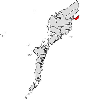
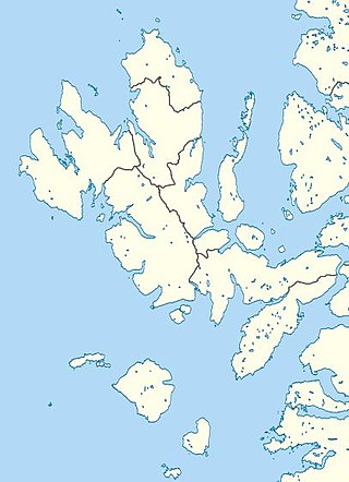
Sgìre an Rubha is one of the 11 wards of Comhairle nan Eilean Siar. Created in 2007, the ward elects two councillors using the single transferable vote electoral system. Originally a three-member ward, the number of members elected in Sgìre an Rubha was reduced following a boundary review and it has elected two councillors since the 2022 Comhairle nan Eilean Siar election.

