History
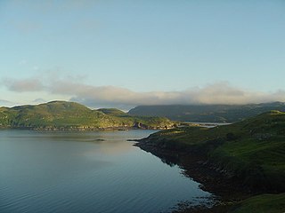
Like many of the surrounding islands, Vacsay is uninhabited due to the Highland Clearances, which occurred here in 1827. [3]
It was bought in 1993 by Sirdar Baron Iqbal Singh, a London business man, who currently lives in Lesmahagow. He has bought the title, "Lord of Butley Manor" and also wishes to rename Vacsay, "Robert Burns' island" [3] or Eilean Burns, [5] although Burns never visited the Outer Hebrides.
Grimsay is a tidal island in the Outer Hebrides of Scotland.

Great Bernera, often known just as Bernera, is an island and community in the Outer Hebrides of Scotland. With an area of just over 21 square kilometres, it is the thirty-fourth largest Scottish island.
The Flannan Isles or the Seven Hunters are a small island group in the Outer Hebrides of Scotland, approximately 32 kilometres west of the Isle of Lewis. They may take their name from Saint Flannan, the 7th century Irish preacher and abbot.

Ronay is an island in the Outer Hebrides of Scotland, which lies a short distance off the east coast of Grimsay.

Seaforth Island is an uninhabited island in the Outer Hebrides of Scotland. Unlike many other islands of the Outer Hebrides which are mainly surrounded by open sea, Seaforth Island lies in a narrow fjord-like sea loch named Loch Seaforth, 8 kilometres (5.0 mi) from the open waters of The Minch.
Eilean Mhealasta is an uninhabited island off the west coast of Lewis in the Outer Hebrides of Scotland. It takes its name from Mealista, a nearby township on Lewis.

Bayble Island lies at the southern end of Bayble Bay. It consists of two islands, but these appear as a single island from most directions. The hamlets of Upper and Lower Bayble overlook the island and bay.

Little Bernera is a small island situated off the west coast of the Isle of Lewis in the Outer Hebrides.
Hermetray is an uninhabited island off North Uist, in the Outer Hebrides of Scotland.

Stockinish Island is an uninhabited island off Harris, in the Outer Hebrides.
Fuaigh Mòr is an island in the Outer Hebrides of Scotland. It is off the west coast of Lewis near Great Bernera in Loch Ròg. It is 84 hectares and 67 metres at its highest point.
Pabay Mòr or Pabaigh Mòr is an uninhabited island in the Outer Hebrides of Scotland.
Stuley is an island lying to the east of South Uist in the Outer Hebrides, Scotland. It lies off the section of coastline between Loch Eynort and Loch Boisdale. It is 45 hectares (0.17 sq mi) and 40 metres (131 ft) at its highest point.

Eilean Liubhaird or Eilean Iubhard is an island in the Outer Hebrides, to the east of Lewis.
Fuaigh Beag or Vuia Be(a)g is an island in the Outer Hebrides. It is off the west coast of Lewis near Great Bernera in Loch Roag. Its name means "little Fuaigh", and is named in contrast to Fuaigh Mòr nearby.
Ceallasaigh Mòr is a low-lying island in Loch Maddy off North Uist in the Outer Hebrides of Scotland. This an area of shallow lagoons filled and drained by the tides each day. Ceallasaigh Beag lies to the south and these two islets are connected by a narrow strip of sand at low tide. Ceallasaigh Mòr may also join mainland North Uist near Bràigh Cheallasaigh at some stages of the tide.

Lewis and Harris, or Lewis with Harris, is a Scottish island in the Outer Hebrides, around 24 miles (39 km) from the Scottish mainland.

Eilean Mòr is an island in Loch Langavat on the Isle of Lewis in the Outer Hebrides of Scotland.
Gasker is a small uninhabited islet in the Outer Hebrides of Scotland, 8 kilometres southwest of Scarp, off the west coast of Harris.
This page is based on this
Wikipedia article Text is available under the
CC BY-SA 4.0 license; additional terms may apply.
Images, videos and audio are available under their respective licenses.


