Rhinns complex

Last updated

Rocks of the Rhinns complex at Claddach bay on the southernmost tip of the Rhinns of Islay Rocks near Claddach bay - geograph.org.uk - 565909.jpg
Rocks of the Rhinns complex at Claddach bay on the southernmost tip of the Rhinns of Islay
Geological map of Islay Islay Geology.png
Geological map of Islay

The Rhinns complex is a deformed Palaeoproterozoic igneous complex that is considered to form the basement to the Colonsay Group of metasedimentary rocks. The largest outcrop of the complex is on the Rhinns of Islay, from where the complex gets its name. It has also been recognised in three other inliers extending to the southwest as far as Inishtrahull, off the north coast of County Donegal.

Contents

Distribution

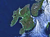
The Rhinns complex has been recognised in a series of four outcrops that form inliers within younger cover sequences of the Dalradian Supergroup and the Colonsay Group. The most easterly of these exposures is on the islands of Colonsay, where the complex consists of strongly retrogressed orthogneisses, [1] although the correlation of this outcrop with the Rhinns complex has been questioned on the basis of new radiometric dating and Hf isotope analyses. [2] On the Rhinns of Islay, gneisses of the Rhinns complex lie unconformably beneath the Colonsay Group, which is correlated with the Dalradian Supergroup. The gneisses on Islay consist of two main types, a dominant medium to coarse-grained syenitic gneiss, which is cut by large intrusions of gabbro (now deformed). Between Islay and Inishtrahull, a third submarine outcrop has been recognised from dredged seabed samples and geophysical data. The final outcrop is on the island of Inishtrahull, which has similar lithologies to that on the Rhinns of Islay. [1]

Formation

The Rhinns complex consists of a set of Palaeoproterozoic igneous rocks that were intruded about 1.78 Ga (billions of years ago). They had been metamorphosed by 1.71 Ga. The overall chemistry of the rocks is consistent with magmatism associated with an Andean type subduction complex. [3]

Related Research Articles

<span class="mw-page-title-main">Rinns of Islay</span> Peninsula in Scotland

The Rinns of Islay is an area on the west of the island of Islay in the Inner Hebrides of Scotland.

<span class="mw-page-title-main">Inishtrahull</span> Island off Malin Head, Ireland

Inishtrahull is the most northerly island of Ireland. It has an area of 34 hectares and lies about ten kilometres northeast of Malin Head, County Donegal, and just over fifty kilometres southwest of the island of Orsay, in the Inner Hebrides of Scotland. The most northerly landfall of Ireland, the Tor Beg rock, is another kilometre to the north. Inishtrahull is home to Ireland's northernmost lighthouse. The island had a resident community until 1929 and the lighthouse was staffed until 1987. Today it is uninhabited and has been designated a protected area due to its wildlife.

<span class="mw-page-title-main">Dalradian</span>

The Dalradian Supergroup is a stratigraphic unit in the lithostratigraphy of the Grampian Highlands of Scotland and in the north and west of Ireland. The diverse assemblage of rocks which constitute the supergroup extend across Scotland from Islay in the west to Fraserburgh in the east and are confined by the Great Glen Fault to the northwest and the Highland Boundary Fault to the southeast. Much of Shetland east of the Walls Boundary Fault is also formed from Dalradian rocks. Dalradian rocks extend across the north of Ireland from County Antrim in the north east to Clifden on the Atlantic coast, although obscured by later Palaeogene lavas and tuffs or Carboniferous rocks in large sections.

<span class="mw-page-title-main">Narryer Gneiss Terrane</span> Geological complex of ancient rocks in Western Australia

The Narryer Gneiss Terrane is a geological complex in Western Australia that is composed of a tectonically interleaved and polydeformed mixture of granite, mafic intrusions and metasedimentary rocks in excess of 3.3 billion years old, with the majority of the Narryer Gneiss Terrane in excess of 3.6 billion years old. The rocks have experienced multiple metamorphic events at amphibolite or granulite conditions, resulting in often complete destruction of original igneous or sedimentary (protolith) textures. Importantly, it contains the oldest known samples of the Earth's crust: samples of zircon from the Jack Hills portion of the Narryer Gneiss have been radiometrically dated at 4.4 billion years old, although the majority of zircon crystals are about 3.6-3.8 billion years old.

<span class="mw-page-title-main">Gascoyne Complex</span> Granite and metamorphic rock in Western Australia

The Gascoyne Complex is a terrane of Proterozoic granite and metamorphic rock in the central-western part of Western Australia. The complex outcrops at the exposed western end of the Capricorn Orogen, a 1,000 km-long arcuate belt of folded, faulted and metamorphosed rocks between two Archean cratons; the Pilbara craton to the north and the Yilgarn craton to the south. The Gascoyne Complex is thought to record the collision of these two different Archean continental fragments during the Capricorn Orogeny at 1830–1780 Ma.

<span class="mw-page-title-main">Geology of Guernsey</span>

Guernsey has a geological history stretching further back into the past than most of Europe. The majority of rock exposures on the Island may be found along the coastlines, with inland exposures scarce and usually highly weathered. There is a broad geological division between the north and south of the Island. The Southern Metamorphic Complex is elevated above the geologically younger, lower lying Northern Igneous Complex. Guernsey has experienced a complex geological evolution with multiple phases of intrusion and deformation recognisable.

Islay is the southernmost island of the Inner Hebrides of Scotland. Known as "The Queen of the Hebrides", it lies in Argyll just south west of Jura and around 40 kilometres north of the Northern Irish coast. The island's capital is Bowmore where the distinctive round Kilarrow Parish Church and a distillery are located. Port Ellen is the main port.

<span class="mw-page-title-main">Moine Supergroup</span>

The Moine Supergroup is a sequence of Neoproterozoic metamorphic rocks that form the dominant outcrop of the Scottish Highlands between the Moine Thrust Belt to the northwest and the Great Glen Fault to the southeast. The sequence is metasedimentary in nature and was metamorphosed and deformed in a series of tectonic events during the Late Proterozoic and Early Paleozoic. It takes its name from A' Mhòine, a peat bog in northern Sutherland.

<span class="mw-page-title-main">Lewisian complex</span> Suite of Precambrian metamorphic rocks that outcrop in the northwestern part of Scotland

The Lewisian complex or Lewisian gneiss is a suite of Precambrian metamorphic rocks that outcrop in the northwestern part of Scotland, forming part of the Hebridean Terrane and the North Atlantic Craton. These rocks are of Archaean and Paleoproterozoic age, ranging from 3.0–1.7 billion years (Ga). They form the basement on which the Torridonian and Moine Supergroup sediments were deposited. The Lewisian consists mainly of granitic gneisses with a minor amount of supracrustal rocks. Rocks of the Lewisian complex were caught up in the Caledonian orogeny, appearing in the hanging walls of many of the thrust faults formed during the late stages of this tectonic event.

Uriconian rocks are volcanic rocks found in parts of Shropshire, United Kingdom. The name relates to Uriconio, the Latin name for an Iron Age hillfort on the summit of the Wrekin, a hill formed of Uriconian rock.

<span class="mw-page-title-main">Wrekin Terrane</span> Inferred basement rock terrane of the southern United Kingdom

The Wrekin Terrane is one of five inferred fault bounded terranes that make up the basement rocks of the southern United Kingdom. The other notable geological terranes in the region are the Charnwood Terrane, Fenland Terrane, Cymru Terrane and the Monian Composite Terrane. The Wrekin Terrane is bounded to the west by the Welsh Borderland Fault System and to the east by the Malvern Lineament. The geological terrane to the west is the Cymru Terrane and to the east is Charnwood Terrane. The majority of rocks in the area are associated with the outcrops that are evident at the faulted boundaries.

The Cymru Terrane is one of five inferred fault bounded terranes that make up the basement rocks of the southern United Kingdom. The other notable geological terranes are the Charnwood Terrane, Fenland Terrane, Wrekin Terrane and the Monian Composite Terrane. In this article the definition of terrane is that implying rocks associated with the composition of the Precambrian basement. The Cymru Terrane is bounded to the northwest by the Menai Strait Fault System and to the southeast by the Pontesford Lineament. The geological terrane to the west is the Monian Composite Terrane and to the east is Wrekin Terrane. The majority of rocks in the area are associated with the outcrops that are evident at the faulted boundaries.

<span class="mw-page-title-main">Colonsay Group</span>

The Colonsay Group is an estimated 5,000 m thick sequence of mildly metamorphosed Neoproterozoic sedimentary rocks that outcrop on the islands of Colonsay, Islay and Oronsay and the surrounding seabed. They have been correlated with the Grampian Group, the oldest part of the Dalradian Supergroup.

The Coal Creek Serpentinite(Coal Creek Serpentine) is a name for a Precambrian rock formation that outcrops on the southeastern side of the Llano Uplift in Gillespie and Blanco counties, Texas. The Coal Creek Serpentinite is tabular south-dipping body of serpentinite. Its outcrop is about 3.7 mi (6.0 km) long along an east–west axis and varies in width from 0.3 to 1.4 mi (0.48 to 2.25 km). Along the central part of the body, the southern contact of the serpentinite slopes about 60° to the south and gradually decreases in dip to about 40° further west. The southern and northern contacts are shear zones. The serpentinite underlies a very sparsely vegetated east–west trending ridge.

<span class="mw-page-title-main">Bowmore Sandstone Group</span>

The Bowmore Sandstone Group is a sequence of metasedimentary rocks, dominantly sandstones, of probable Neoproterozoic age. Their outcrop on the island of Islay in the Inner Hebrides is entirely fault-bounded, between the Loch Gruinart Fault to the west and the Loch Skerrols Shear Zone to the east.

<span class="mw-page-title-main">Tectonic evolution of the Aravalli Mountains</span> Overview article

The Aravalli Mountain Range is a northeast-southwest trending orogenic belt in the northwest part of India and is part of the Indian Shield that was formed from a series of cratonic collisions. The Aravalli Mountains consist of the Aravalli and Delhi fold belts, and are collectively known as the Aravalli-Delhi orogenic belt. The whole mountain range is about 700 km long. Unlike the much younger Himalayan section nearby, the Aravalli Mountains are believed much older and can be traced back to the Proterozoic Eon. They are arguably the oldest geological feature on Earth. The collision between the Bundelkhand craton and the Marwar craton is believed to be the primary mechanism for the development of the mountain range.

The geology of Uganda extends back to the Archean and Proterozoic eons of the Precambrian, and much of the country is underlain by gneiss, argillite and other metamorphic rocks that are sometimes over 2.5 billion years old. Sedimentary rocks and new igneous and metamorphic units formed throughout the Proterozoic and the region was partially affected by the Pan-African orogeny and Snowball Earth events. Through the Mesozoic and Cenozoic, ancient basement rock has weathered into water-bearing saprolite and the region has experienced periods of volcanism and rift valley formation. The East Africa Rift gives rise to thick, more geologically recent sediment sequences and the country's numerous lakes. Uganda has extensive natural resources, particularly gold.

<span class="mw-page-title-main">Geology of Sudan</span>

The geology of Sudan formed primarily in the Precambrian, as igneous and metamorphic crystalline basement rock. Ancient terranes and inliers were intruded with granites, granitoids as well as volcanic rocks. Units of all types were deformed, reactivated, intruded and metamorphosed during the Proterozoic Pan-African orogeny. Dramatic sheet flow erosion prevented almost any sedimentary rocks from forming during the Paleozoic and Mesozoic. From the Mesozoic into the Cenozoic the formation of the Red Sea depression and complex faulting led to massive sediment deposition in some locations and regional volcanism. Sudan has petroleum, chromite, salt, gold, limestone and other natural resources.

The geology of South Korea includes rocks dating to the Archean and two large massifs of metamorphic rock as the crystalline basement, overlain by thick sedimentary sequences, younger metamorphic rocks and volcanic deposits. Although extent is small, Geology is diverse, and there are diverse rocks that were formed during the Precambrian to Cenozoic Era in the Korea Peninsula.

The geology of Loch Lomond and The Trossachs National Park in the southwestern part of the Scottish Highlands consists largely of Neoproterozoic and Palaeozoic bedrock faulted and folded and subjected to low grade metamorphism during the Caledonian orogeny. These older rocks, assigned to the Dalradian Supergroup, lie to the northwest of the northeast – southwest aligned Highland Boundary Fault which defines the southern edge of the Highlands. A part of this mountainous park extends south of this major geological divide into an area characterised by younger Devonian rocks which are assigned to the Old Red Sandstone.

References

  1. 1 2 Muir, R.J.; Fitches W.R.; Maltman A.J.; Bentley M.R. (1994). "Precambrian rocks of the southern Inner Hebrides—Malin Sea region: Colonsay, west Islay, Inishtrahull and Iona". In Harris A.L. & Gibbons W. (ed.). A Revised Correlation of Precambrian Rocks in the British Isles. Special Report. Vol. 22 (2 ed.). London: Geological Society. pp. 54–56. ISBN   9781897799116 . Retrieved 15 September 2012.
  2. Daly, J.S.; Flowerdew M.J.; McAteer C.; Horstwood M.S.A.; Whitehouse M.J.; Chew D.M. (2009). "Palaeoproterozoic orthogneiss on Colonsay, SW Scotland" (PDF). 52nd Irish Geological Research Meeting. p. 28. Retrieved 15 September 2012.
  3. Daly, J.S.; Muir R.J.; Cliff R.A. (1991). "A precise U-Pb zircon age for the Inishtrahull syenitic gneiss, County Donegal, Ireland". Journal of the Geological Society. Geological Society. 148 (4): 639–642. doi:10.1144/gsjgs.148.4.0639 . Retrieved 15 September 2012.

55°40′N6°33′W / 55.67°N 6.55°W / 55.67; -6.55