Scapa Flow is a body of water in the Orkney Islands, Scotland, sheltered by the islands of Mainland, Graemsay, Burray, South Ronaldsay and Hoy. Its sheltered waters have played an important role in travel, trade and conflict throughout the centuries. Vikings anchored their longships in Scapa Flow more than a thousand years ago. It was the United Kingdom's chief naval base during the First and Second World wars, but the facility was closed in 1956.

Formigas Islets, sometimes referred to as the Formigas Bank, are a group of uninhabited rocky outcroppings in the eastern group of the Azores archipelago, an autonomous region of Portugal. The bank is located 43 kilometres (27 mi) northeast of Santa Maria and southeast of São Miguel, covering a surface area of approximately 9,000 square metres (97,000 sq ft). The submerged Dollabarat Reef is in the same area. The only structure on the islets is a lighthouse located on Formigão, the largest islet.

HMS Otranto was an armed merchant cruiser requisitioned by the British Admiralty when World War I began in 1914. Built before the war for the UK–Australia run as SS Otranto, she was primarily used in the war to search for German commerce raiders. She played small roles in the Battle of Coronel in November 1914 when the German East Asia Squadron destroyed the British squadron searching for it and in the Battle of the Falkland Islands the following month when a British squadron annihilated the Germans in turn.

The Manacles are a set of treacherous rocks off The Lizard peninsula in Cornwall. The rocks are rich in marine wildlife and they are a popular spot for diving due to the many shipwrecks. Traditionally pronounced mean-a'klz (1808), the name derives from the Cornish meyn eglos, the top of St Keverne church spire being visible from the area.

Calve Island is an uninhabited low-lying island off the east coast of the Isle of Mull in Argyll and Bute on the west coast of Scotland. A whitewashed farmhouse with substantial outbuildings stands on the western shore, used as a summer residence. The island is 1+1⁄4 miles in length, and 1⁄2 mile wide at its widest point. Calve is owned by the Cotton family who make use of it in the summer months.

Downderry is a coastal village in south-east Cornwall, England, United Kingdom. It is 12 miles (19 km) west of Plymouth and one mile east of Seaton.
Kilchoman is a small settlement and large parish on the Scottish island of Islay, within the unitary council of Argyll and Bute.

Boat Harbour is a small beach located on the southern side of the Botany Bay National Park in Kurnell, Sydney, New South Wales, Australia.

SS James Eagan Layne was a liberty ship. She was beached and sunk during the Second World War off Whitsand Bay, Cornwall, United Kingdom.

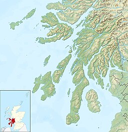
Islay is the southernmost island of the Inner Hebrides of Scotland. Known as "The Queen of the Hebrides", it lies in Argyll and Bute just south west of Jura and around 40 kilometres north of the Northern Irish coast. The island's capital is Bowmore where the distinctive round Kilarrow Parish Church and a distillery are located. Port Ellen is the main port.
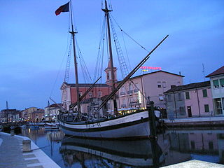
The trabàccolo, trabaccalo, trabacalo or trabakul, is a type of Adriatic Sea sailing coaster. The name comes from the word trabacca, which means tent, which in turn recalls the vessel's sails. The trabàccolo was a typical Venetian boat-form that dates back to the first half of the 15th century and that spread throughout the Adriatic. Built of oak and larch, trabàccoli were slow but reliable cargo vessels ranging between 50 and 200 deadweight tons. They had round bows and sterns, and were wide, compact, and with good stowage. Other characteristics included a large rudder that extended below the depth of the keel, two masts with lug sails and rigging, a bowsprit, and a carved and colorfully painted stern. The usual such vessel was about 20 metres long, with a breadth equal to about a third of the length. Typically a trabàccolo would have a crew of 10 to 20 sailors.

The RMS Mülheim was a German cargo ship that was built in Romania and launched in May 1999. It was wrecked on 22 March 2003 at Land's End, United Kingdom.
Events from the year 1918 in Scotland.
SS Telefon was a Norwegian cargo steamship of about 1,400 GRT built by on the River Tyne in 1900. She was wrecked in South Shetland Islands in 1908, though later salved, repaired and returned to service. She was sunk in a collision off Denmark in 1913 as the British Kinneil.
The following index is provided as an overview of and topical guide to Wikipedia's articles on recreational dive sites. The level of coverage may vary:
The Hive Shipwreck is a heritage-listed shipwreck site of the Hive, a former convict transportation ship located approximately 40 metres (130 ft) off Bherwerre Beach, Jervis Bay Territory, Australia. It was added to the New South Wales State Heritage Register on 1 April 2010.

Recreational dive sites are specific places that recreational scuba divers go to enjoy the underwater environment or for training purposes. They include technical diving sites beyond the range generally accepted for recreational diving. In this context all diving done for recreational purposes is included. Professional diving tends to be done where the job is, and with the exception of diver training and leading groups of recreational divers, does not generally occur at specific sites chosen for their easy access, pleasant conditions or interesting features.