
Claggain Bay is an inlet on the southeast of Islay, Scotland. A well known walking path follows near to Claggain Bay and continues to Ardtalla. [1]
Claggain Bay is an inlet on the southeast of Islay, Scotland. A well known walking path follows near to Claggain Bay and continues to Ardtalla. [1]
55°42′25″N6°02′10″W / 55.7069°N 6.0361°W
| Villages | 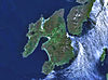 | |
|---|---|---|
| Geographical features | ||
| History and architecture |
| |
| Islay whisky | ||
| Other Islay related articles | ||
| | This Scottish location article is a stub. You can help Wikipedia by expanding it. |