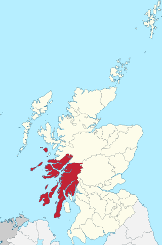
Argyll, sometimes called Argyllshire, is a historic county and registration county of western Scotland. The county ceased to be used for local government purposes in 1975 and most of the area now forms part of the larger Argyll and Bute council area.

Loch Leven is a sea loch located onto the west coast of Scotland. It is spelled Loch Lyon in Timothy Pont's map of the area and is pronounced Li' un. However, the local Gaelic pronunciation is Lee' oon

Jura distillery is Island single malt Scotch whisky distillery located on the island of Jura in the Inner Hebrides off the West Coast of Scotland.

The Crowlin Islands are a group of uninhabited islands in the Inner Hebrides of Scotland. They lie between Skye and the Applecross peninsula on the mainland.

This particular Eilean Dubh is sometimes known as Glen Caladh Island and lies just off the Cowal peninsula in the Kyles of Bute. The island is around 0.3 kilometres at its longest length and rises to a height of 19 metres above sea level. It is almost entirely covered by woodland.

Portnahaven is a village on Islay in the Inner Hebrides, Scotland. The village is within the parish of Kilchoman.
Lunga is one of the Slate Islands in the Firth of Lorn in Argyll and Bute, Scotland. The "Grey Dog" tidal race, which runs in the sea channel to the south, reaches 8 knots (15 km/h) in full flood. The name "Lunga" is derived from the Old Norse for "isle of the longships', but almost all other place names are Gaelic in origin.

Texa is a small island 700 metres directly south of Islay, in the Inner Hebrides, Scotland. It reaches a height of 48 metres at its highest point, Ceann Garbh. It is part of the parish of Kildalton on Islay. The distilleries of Laphroaig and Lagavulin are nearby on the Islay coast, as well as Port Ellen. It is currently inhabited, but is home to wild goats, as well as otters.

Bayble Island is an uninhabited island off the south coast of the Eye Peninsula of Lewis, in the Outer Hebrides of Scotland.

Finlaggan is a historic site on Eilean Mòr in Loch Finlaggan. The Loch, the island, and Finlaggan Castle lie on Islay, around two kilometres to the northwest of Ballygrant.

Nave Island lies to the north of Islay in the Inner Hebrides near the mouth of Loch Gruinart. It is uninhabited.
Na h-Eileanan Iasgaich comprise a small uninhabited archipelago in Loch Boisdale, in the south east of the island of South Uist, in the Outer Hebrides, Scotland. The individual islands are separated from one another at high tide, but connected to one another at low tide,. They are around 50 ha in extent and over 20m at their highest point. Their boundaries are ill-defined.
Alexander Mackenzie, known as "Ionraic", traditionally counted as 6th of Kintail, was the first chief of the Clan Mackenzie of whom indisputable contemporary documentary evidence survives. During his long life, he greatly expanded his clan's territories and influence.

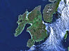
Islay is the southernmost island of the Inner Hebrides of Scotland. Known as "The Queen of the Hebrides", it lies in Argyll and Bute just south west of Jura and around 40 kilometres north of the Northern Irish coast. The island's capital is Bowmore where the distinctive round Kilarrow Parish Church and a distillery are located. Port Ellen is the main port.

Loch Gorm Castle is a ruined castle located on Eilean Mòr on Loch Gorm, Islay, Scotland. It was built in the early 15th century and served as a stronghold for Clan Donald.

Eilean Mhic Chrion is a tidal island sheltering Ardfern in Loch Craignish, Scotland.

The Sound of Islay is a narrow strait between the islands of Islay and Jura off the west coast of Scotland. It is about 30 kilometres in extent from north to south and lies between Rubh' a' Mhàil on Islay and Rubh' Aird na Sgitheich on Jura to the north and Macarthur's Head and Rubha na Tràille to the south. The islands in the Sound are Am Fraoch Eilean, Brosdale Island and Glas Eilean, all of which are off the south east coast of Jura. These islands, Jura south of Loch Tarbert and the eastern part of the Sound are one of 40 National Scenic Areas in Scotland.

Description of the Western Isles of Scotland is the oldest known account of the Hebrides and the Islands of the Clyde, two chains of islands off the west coast of Scotland. The author was Donald Monro, a clergyman who used the title of "Dean of the Isles" and who lived through the Scottish Reformation. Monro wrote the original manuscript in 1549, although it was not published in any form until 1582 and was not widely available to the public in its original form until 1774. A more complete version, based on a late 17th-century manuscript written by Sir Robert Sibbald, was first published as late as 1961. Monro wrote in Scots and some of the descriptions are difficult for modern readers to render into English. Although Monro was criticised for publishing folklore and for omitting detail about the affairs of the churches in his diocese, Monro's Description is a valuable historical account and has reappeared in part or in whole in numerous publications, remaining one of the most widely quoted publications about the western islands of Scotland.