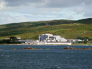
Lagavulin distillery is an Islay single malt Scotch whisky distillery located in the village of Lagavulin on the south of the island of Islay, Scotland.
Port Ellen distillery is located in Port Ellen on the isle of Islay, Scotland.

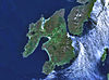
Lagavulin is a small village approximately 3 miles outside Port Ellen on the Isle of Islay, Scotland. The village is within the parish of Kildalton, and is situated on the A846 road.
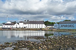
Laphroaig distillery is a single malt Scotch whisky distillery on Islay, Scotland. It is situated on the south coast of the island, near Port Ellen, at the head of a small bay known as Loch Laphroaig. The Lagavulin and Ardbeg distilleries are close by.
This is a list of the extreme points of the United Kingdom: the points that are farther north, south, east or west than any other location. Traditionally the extent of the island of Great Britain has stretched "from Land's End to John o' Groats".
Cara Island is a small island which is located off the west coast of Kintyre in Scotland.

Caol Ila distillery is a Scotch whisky distillery near Port Askaig on the isle of Islay, Scotland, owned by Diageo.
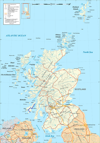
The A846 road is one of the two principal roads of Islay in the Inner Hebrides off the west coast of mainland Scotland and the only 'A' road on the neighbouring island of Jura.
Hazelburn distillery was Campbeltown single malt Scotch whisky distillery in Campbeltown, Scotland, which was in operation between approximately 1825 and 1925.
Eden Water is a tributary of the River Tweed in the Scottish Borders of Scotland. "Water" is the Lowland Scots term for a small river.

Texa is a small island 700 metres directly south of Islay, in the Inner Hebrides, Scotland. It reaches a height of 48 metres at its highest point, Ceann Garbh. It is part of the parish of Kildalton on Islay. The distilleries of Laphroaig and Lagavulin are nearby on the Islay coast, as well as Port Ellen. It is currently uninhabited, but is home to wild goats, as well as otters.
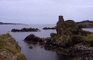
Dunyvaig Castle is located on the south side of Islay, in Argyll, Scotland, on the shore of Lagavulin Bay, 4 kilometres from Port Ellen. The castle was once a naval base of the Lord of the Isles, chiefs of Clan Donald. It was held by the chiefs of the Clan MacDonald of Dunnyveg.
Pescueza is a municipality located in the province of Cáceres, Extremadura, Spain. According to the 2005 census (INE), the municipality has a population of 167 inhabitants.

Urie Lingey is one of the Shetland Islands. It is between Fetlar and Unst, and Yell is to the west.

Unalaska is a volcanic island in the Fox Islands group of the Aleutian Islands in the US state of Alaska located at 53°38′N167°00′W. The island has a land area of 1,051 square miles (2,720 km2). It measures 79.4 mi (127.8 km) long and 34.7 mi (55.8 km) wide. The city of Unalaska, Alaska, covers part of the island and all of neighboring Amaknak Island where the Port of Dutch Harbor is located. The population of the island excluding Amaknak as of the 2000 census was 1,759 residents.
The Croker River is a waterway above the Arctic Circle on the mainland of Northern Canada in the western Kitikmeot Region, Nunavut. It is the largest river between Darnley Bay and Coronation Gulf that flows into Amundsen Gulf. The Croker averages 55 m (180 ft) in width.

Aros Bay is an embayment of ocean waters near the southeast of Islay, Scotland.

Claggain Bay is an inlet on the southeast of Islay, Scotland. A well known walking path follows near to Claggain Bay and continues to Ardtalla.
Brunswick is a settlement in British Columbia, located near the Village of Lions Bay. The name Brunswick is used for the railway point and former flagstop at this location for the British Columbia Railway.

Manor Water is a river in the parish of Manor, Peeblesshire in the Scottish Borders. It rises in the Ettrick Forest and flows down through the Maynor valley, passing the various farms and hamlets of Maynor as well as Kirkton Manynor, where the Maynor kirk and village hall are flowing into the River Tweed one mile south of Peebles at Olde Maynor Brig, which is closed to traffic for the foreseeable future.