Royal Air Force Bishopscourt or more simply RAF Bishopscourt is a former Royal Air Force airfield, radar control and reporting station located on the south east coast of Northern Ireland, approximately 5.8 miles (9.3 km) from Downpatrick, County Down, Northern Ireland and 24.7 miles (39.8 km) from Belfast, Northern Ireland. A Marconi AMES Type 84 radar was located on the airfield and an AMES Type 80 radar was located at Killard Point, Ballyhornan. An AMES Type 93 mobile radar was also located on the airfield from 1989 until the station closed.

ROTOR was an elaborate air defence radar system built by the British Government in the early 1950s to counter possible attack by Soviet bombers. To get it operational as quickly as possible, it was initially made up primarily of WWII-era systems, notably the original Chain Home radars for the early warning role, and the AMES Type 7 for plotting and interception control. Data from these stations was sent to a network of control stations, mostly built underground, using an extensive telephone and telex network.

Remote Radar Head Benbecula or RRH Benbecula, is an air defence radar station operated by the Royal Air Force. It is located at Cleitreabhal a'Deas, 17 kilometres (11 mi) from Lochmaddy on the isle of North Uist in the Outer Hebrides of Scotland.
Remote Radar Head Saxa Vord or RRH Saxa Vord, is a Royal Air Force radar station located on the island of Unst, the most northern of the Shetland Islands in Scotland. As of July 2019 it is once more a fully operational radar station, after closure in 2006. The station's motto Praemoneo de Periculis reflects its role. RAF Saxa Vord is further north than Saint Petersburg in Russia, and on the same latitude as Anchorage, Alaska. The station was named after Saxa Vord, which is the highest hill on Unst at 935 ft (285 m). It holds the unofficial British record for wind speed, which in 1992 was recorded at 197 mph (317 km/h) — just before the measuring equipment blew away.

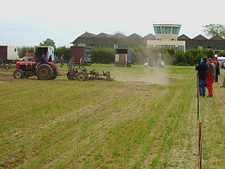
Islay Airport is located 4.5 nautical miles north-northwest of Port Ellen on the island of Islay in Argyll and Bute, off the west coast of Scotland. It is a small rural airport owned and maintained by Highlands and Islands Airports Limited. Today the airport is used for scheduled services to the Scottish mainland, and for air ambulances.
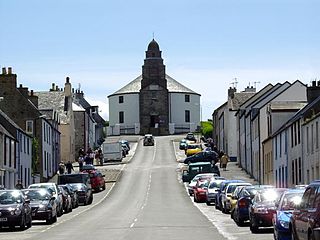
Bowmore is a small town on the Scottish island of Islay. It serves as administrative capital of the island, and gives its name to the noted Bowmore distillery producing Bowmore single malt scotch whisky.
A BT site engineering code is a group of letters assigned by BT, or its predecessor the General Post Office, to a physical location which is equipped by the company with unusual amounts or types of telecommunications.

Port Askaig is a port village on the east coast of the island of Islay, in Scotland. The village lies on the Sound of Islay across from Jura.

Machrihanish is a village in Argyll, on the west coast of Scotland. It is a short distance north of the tip of the Mull of Kintyre, which faces out towards Northern Ireland and the Atlantic.

No. 245 Squadron was a squadron of the Royal Air Force. It flew as an anti-submarine squadron during World War I and as a fighter squadron during World War II. After the war it was first a jet-fighter squadron and its last role was as a radar-calibration unit.
Royal Air Force Lindholme or more simply RAF Lindholme is a former Royal Air Force station in South Yorkshire, England. It was located 3.9 miles (6.3 km) south of Thorne and 6.9 miles (11.1 km) north east of Doncaster and was initially called RAF Hatfield Woodhouse.

Royal Air Force Goldsborough or more simply RAF Goldsborough is a former Royal Air Force station located in North Yorkshire, England.
Remote Radar Head Buchan or RRH Buchan is an air defence radar station operated by the Royal Air Force. It is located at Stirling Hill, 3.2 kilometres (2.0 mi) south of Peterhead on the Aberdeenshire coast of North East Scotland.
No. 199 Squadron was a Royal Air Force aircraft squadron that operated during the Second World War and later in the 1950s as a radar countermeasures squadron.
RAF Sopley was a World War II station, codenamed Starlight, near the village of Sopley in Hampshire. The Radar Station was opened in December 1940. In 1959 it became an air traffic control radar station, and finally closed on 27 September 1974. Nearby Sopley Camp was built in the early 1950s as a domestic site for the radar station and is probably best known as the initial home of the Vietnamese Boat People, in 1979. The camp was sold in 1993 to a local partnership under the name Merryfield Park. Most of the old barracks site had been redeveloped as housing, but the 2-storey building at the Sopley end has been converted into a museum/education centre by Friends Of New Forest Airfields (FONFA). The museum opened in May 2016.
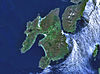
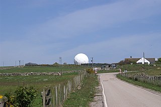
Islay is the southernmost island of the Inner Hebrides of Scotland. Known as "The Queen of the Hebrides", it lies in Argyll just south west of Jura and around 40 kilometres north of the Northern Irish coast. The island's capital is Bowmore where the distinctive round Kilarrow Parish Church and a distillery are located. Port Ellen is the main port.
No. 165 Squadron RAF was a unit of the Royal Air Force that was formed during World War I and served during World War II. The squadron has been formed twice.
No. 527 Squadron RAF was a radar calibration unit of the Royal Air Force between 1943 and 1958.

Royal Air Force Aird Uig was a Royal Air Force radar station located on the western edge of the Isle of Lewis in the Outer Hebrides, Scotland. The main masts and operations room were located north of the village of Aird Uig on Gallan Head, with a separate domestic site nearer to the village, five-eighths mile further south.