Royal Air Force Bishopscourt or more simply RAF Bishopscourt is a former Royal Air Force airfield, radar control and reporting station located on the south east coast of Northern Ireland, approximately 5.8 miles (9.3 km) from Downpatrick, County Down, Northern Ireland and 24.7 miles (39.8 km) from Belfast, Northern Ireland. A Marconi AMES Type 84 radar was located on the airfield and an AMES Type 80 radar was located at Killard Point, Ballyhornan. An AMES Type 93 mobile radar was also located on the airfield from 1989 until the station closed.

ROTOR was an elaborate air defence radar system built by the British Government in the early 1950s to counter possible attack by Soviet bombers. To get it operational as quickly as possible, it was initially made up primarily of WWII-era systems, notably the original Chain Home radars for the early warning role, and the AMES Type 7 for plotting and interception control. Data from these stations was sent to a network of control stations, mostly built underground, using an extensive telephone and telex network.

Royal Air Force Boulmer or more simply RAF Boulmer is a Royal Air Force station near Alnwick in Northumberland, England, and is home to Aerospace Surveillance and Control System (ASACS) Force Command, Control and Reporting Centre (CRC) Boulmer.
Royal Air Force Buchan or more simply RAF Buchan is a former Royal Air Force station near Peterhead in Aberdeenshire, Scotland.
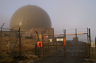
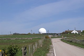
Remote Radar Head Saxa Vord or RRH Saxa Vord, is a Royal Air Force radar station located on the island of Unst, the most northern of the Shetland Islands in Scotland. As of July 2019 it is once more a fully operational radar station, after closure in 2006. The station's motto Praemoneo de Periculis reflects its role. RAF Saxa Vord is further north than Saint Petersburg in Russia, and on the same latitude as Anchorage, Alaska. The station was named after Saxa Vord, which is the highest hill on Unst at 935 ft (285 m). It holds the unofficial British record for wind speed, which in 1992 was recorded at 197 mph (317 km/h) — just before the measuring equipment blew away.

Remote Radar Head Neatishead, and commonly abbreviated RRH Neatishead, is an air defence radar site operated by the Royal Air Force (RAF). It is located approximately 11 kilometres north-east of Norwich in the county of Norfolk, England.

Ground-controlled interception (GCI) is an air defence tactic whereby one or more radar stations or other observational stations are linked to a command communications centre which guides interceptor aircraft to an airborne target. This tactic was pioneered during World War I by the London Air Defence Area organization, which became the Royal Air Force's Dowding system in World War II, the first national-scale system. The Luftwaffe introduced similar systems during the war, but most other combatants did not suffer the same threat of air attack and did not develop complex systems like these until the Cold War era.
AMES, short Air Ministry Experimental Station, was the name given to the British Air Ministry's radar development team at Bawdsey Manor in the immediate pre-World War II era. The team was forced to move on three occasions, changing names as part of these moves, so the AMES name applies only to the period between 1936 and 1939.
Regional seats of government or RSGs were the best known aspect of Britain's civil defence preparations against nuclear war. In fact, however, naming conventions changed over the years as strategies in Whitehall changed.

Royal Air Force Ash or more simply RAF Ash was a Royal Air Force underground control centre and radar station situated near the village of Woodnesborough, Kent, England.
Royal Air Force Bempton or more simply RAF Bempton is a former Royal Air Force station situated at Bempton in the East Riding of Yorkshire, England, 6 miles (10 km) north of Bridlington. During the Second World War it was established as a radar station, becoming part of the Chain Home Low (CHL) network.

Royal Air Force Ventnor or more simply RAF Ventnor is a former Royal Air Force radar station located 0.7 miles (1.1 km) north east of Ventnor on the Isle of Wight, England. It was initially constructed in 1937 as part of a World War II coastal defence programme codenamed Chain Home. The site played an important role during the Second World War, providing early warnings of incoming bomber attacks carried out by the Luftwaffe.
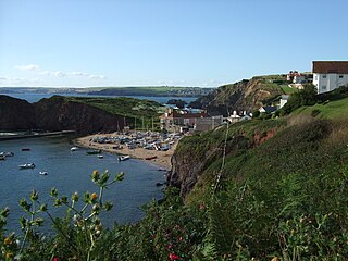
Hope Cove is a small seaside village within the civil parish of South Huish in South Hams District, Devon, England. It is located 5 miles (8.0 km) west of Salcombe and 5 miles (8.0 km) south west of Kingsbridge. It has two beaches, and is sheltered by the headland of Bolt Tail.
RAF Sopley was a World War II station, codenamed Starlight, near the village of Sopley in Hampshire. The Radar Station was opened in December 1940. In 1959 it became an air traffic control radar station, and finally closed on 27 September 1974. Nearby Sopley Camp was built in the early 1950s as a domestic site for the radar station and is probably best known as the initial home of the Vietnamese Boat People, in 1979. The camp was sold in 1993 to a local partnership under the name Merryfield Park. Most of the old barracks site had been redeveloped as housing, but the 2-storey building at the Sopley end has been converted into a museum/education centre by Friends Of New Forest Airfields (FONFA). The museum opened in May 2016.
Royal Air Force Bolt Head or more simply RAF Bolt Head is a former Royal Air Force satellite airfield 1 mile (1.6 km) south west of Salcombe on the south Devon coast, England from 1941 to 1945. During the Second World War it was used as a satellite for RAF Exeter. There were two runways, of 3,680 ft at 45° and 4,200 ft at 120°

Royal Air Force Holmpton or more simply RAF Holmpton is a former Royal Air Force Cold War era nuclear bunker that was built in the 1950s as an early warning radar station as part of the ROTOR Radar Defence Programme. Located just south of the village of Holmpton, in the East Riding of Yorkshire, England, RAF Holmpton remained a part of the Defence Estate right up to 8 December 2014 when it was sold into private ownership after 62 years of military service.
RAF Wartling was a Royal Air Force station located near the village of Wartling in East Sussex. It was a Second World War and later Cold War Ground Controlled Interception (GCI) station built to complement the nearby Chain Home station at RAF Pevensey.

The AMES Type 80, sometimes known by its development rainbow code Green Garlic, was a powerful early warning (EW) and ground-controlled interception (GCI) radar developed by the Telecommunications Research Establishment (TRE) and built by Decca for the Royal Air Force (RAF). It could reliably detect a large fighter or small bomber at ranges over 210 nautical miles, and large, high-flying aircraft were seen out to the radar horizon. It was the primary military ground-based radar in the UK from the mid-1950s into the late 1960s, providing coverage over the entire British Isles.

The AMES Type 7, also known as the Final GCI, was a ground-based radar system introduced during World War II by the Royal Air Force (RAF). The Type 7 was the first truly modern radar used by the Allies, providing a 360 degree view of the airspace around the station out to a distance of about 90 miles (140 km). It allowed fighter interceptions to be plotted directly from the radar display, a concept known as ground controlled intercept, or GCI.