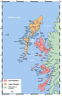
The Hebrides are a Scottish archipelago off the west coast of the Scottish mainland. The islands fall into two main groups, based on their proximity to the mainland: the Inner and Outer Hebrides.
Scalpay is an inhabited island in the Inner Hebrides of Scotland which has a population of 4.

The Slate Islands are an island group in the Inner Hebrides, lying immediately off the west coast of Scotland, north of Jura and southwest of Oban. The main islands are Seil, Easdale, Luing, Shuna, Torsa and Belnahua. Scarba and Kerrera, which lie nearby, are not usually included.
Scalpay is an island in the Outer Hebrides of Scotland.
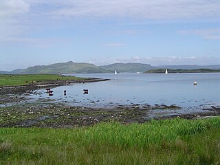
Luing is one of the Slate Islands, Firth of Lorn, in the west of Argyll in Scotland, about 16 miles (26 km) south of Oban. The island has an area of 1,430 hectares and is bounded by several small skerries and islets. It has a population of around 200 people, mostly living in Cullipool, Toberonochy, and Blackmillbay.
The Treshnish Isles are an archipelago of small islands and skerries, lying west of the Isle of Mull, in Scotland. They are part of the Inner Hebrides. Trips to the Treshnish Isles operate from Ulva Ferry, Tobermory Ardnamurchan and Tiree
Boreray is an island with a single croft, lying 2 kilometres (1.2 mi) north of North Uist in the Outer Hebrides of Scotland.

Eilean Bàn is a six-acre (2.4 ha) island between Kyle of Lochalsh and the Isle of Skye, in the historic county of Ross and Cromarty in the Highland local government area. The Skye Bridge uses the island as a stepping-stone as it crosses the mouth of Loch Alsh from the mainland to Skye.

Grimsay, south east of Benbecula is a tidal island of the Outer Hebrides. It is connected to Benbecula by a causeway which carries the B891. In the 2001 census, Grimsay had a population of 19, and 20 in 2011.
There are many small islands in Scotland called Flodday or similar and this list provides a guide to their location. The derivation of the name is from the Old Norse floti meaning "raft" or "float". The similar island names Fladda and Flotta are also from the Norse flatr and mean "flat island". Usage is not always consistent in external sources.
Longa Island is a small uninhabited island at the mouth of Loch Gairloch, on the west coast of Scotland. Longa is nearly one mile in length with an area of 126 hectares and a maximum elevation of 70 metres (230 ft) above sea level.
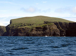
Arnamul is a stack off the west coast of Mingulay in the Western Isles, Scotland. Although precipitous, sheep were grazed on its relatively flat summit during the human occupation of Mingulay.
Gunna is an island in the Inner Hebrides of Scotland.
Hermetray is an uninhabited island off North Uist, in the Outer Hebrides of Scotland.

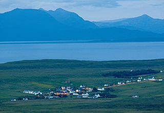
Portnalong is a small village on north west of the Isle of Skye on the shore of Loch Harport. Portnalong is Gaelic for "harbour of the ships". It was founded by crofters from Lewis and Harris in 1921.

Glendale is a community-owned estate on the north-western coastline of the Duirinish peninsula on the island of Skye and is in the Scottish council area of Highland. The estate encompasses the small crofting townships of Skinidin, Colbost, Fasach, Glasphein, Holmisdale, Lephin, Hamaraverin, Borrodale, Milovaig and Waterstein, Feriniquarrie, Totaig, Glasphein, Hamara, and others
Staffin is a district with the Gaelic name An Taobh Sear, which translates as "the East Side", on the northeast coast of the Trotternish peninsula of the island of Skye. It is located on the A855 road about 17 miles north of Portree and is overlooked by the Trotternish Ridge with the famous rock formations of The Storr and the Quiraing. The district comprises 23 townships made up of, from south to north, Rigg, Tote, Lealt, Lonfearn, Grealin, Breackry, Cul-nan-cnoc, Bhaltos, Raiseburgh, Ellishadder, Garafad, Clachan, Garros, Marrishader, Maligar, Stenscholl, Brogaig, Sartle, Glasphein, Digg, Dunan, Flodigarry and Greap. The Kilmartin River runs northwards through the village. From where it reaches the sea a rocky shore leads east to a slipway at An Corran. Here a local resident found a slab bearing a dinosaur track, probably made by a small ornithopod. Experts subsequently found more dinosaur prints of up to 50 cm, the largest found in Scotland, made by a creature similar to Megalosaurus. At about 160 million years old they are the youngest dinosaur remains to be found in Scotland.

Minginish is a peninsula on the Isle of Skye in Scotland. It is situated on the west coast of the island and runs from Loch Scavaig in the south, along the western coast of Skye to Loch Bracadale in the north west, to Loch Harport in the north east, and Glen Sligachan in the south east. It includes most of the peaks of the Cuillin hills including Sgurr Alasdair, the highest point on the island at 992 metres (3,255 ft). The island of Soay lies offshore across the Soay Sound, with the Small Isles further south across the Cuillin Sound.
Duirinish is a peninsula on the island of Skye in Scotland. It is situated in the north west between Loch Dunvegan and Loch Bracadale.

Eilean na Cille, south east of Benbecula is an island of the Outer Hebrides connected to Grimsay (South) by a causeway which carries the B891. The road was built to service the pier at Peter's Port, which was constructed in 1896 at cost of £2,000 – although the anchorage is awkward and should not be used without local knowledge.


