Tarner Island is a triangular shaped island in Loch Bracadale just off the coast off the Harlosh peninsula of Skye in Scotland.[1][2] It is about 28 hectares (69 acres) in extent and is 0.65 miles at its longest by 0.33 miles at its widest
Looking south east from Harlosh Point, to Tarner Island, over Loch Bracadale.
The coastline is largely cliff-lined and rocky however slopes down to the northernmost part of the island at which point it is possible to land by small boat or kayak.
Tarner Island is dotted with small sea caves around the perimeter, many large enough to kayak into, and there is a natural arch to the north. The west of the island is dominated by cliffs and a large leaning boulder, known as 'Fingal's Limpet Hammer'. ("A huge block of trap, which has slipped from the face of a cliff in one of the islands of Loch Bracadale in Skye, is called ' Ord-bàirnich Fhinn,' Fingal's limpet-hammer."[3]
Tarner Island is 0.5 miles from mainland Skye at its nearest point and there are several skerries including Sgeir Mhòr and Sgeir Bheag that lie just offshore to the north east between the island and Colbost Head.[1] Grey seals frequent these skerries and can be seen in numbers around Tarner Island.
There is a large colony of Common Gulls which nest on the shore as well as Oystercatchers and other gulls. Cormorants nest in numbers around the coast.
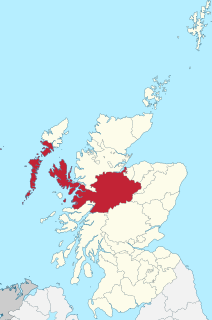
Ross and Cromarty, sometimes referred to as Ross-shire and Cromartyshire, is a variously defined area in the Highlands and Islands of Scotland. There is a registration county and a lieutenancy area in current use, the latter of which is 8,019 square kilometres in extent. Historically there has also been a constituency of the Parliament of the United Kingdom, a local government county, a district of the Highland local government region and a management area of the Highland Council. The local government county is now divided between two local government areas: the Highland area and Na h-Eileanan Siar. Ross and Cromarty border Sutherland to the north and Inverness-shire to the south.
Ullinish is a crofting township on Loch Bracadale, on the southwest coast of Skye, Scotland. The only promontory fort on Skye is located at Ullinish. It is situated to the west of Struan and just south of the hamlet of Ebost. Historically, Ullinish is associated with the MacLeod family. Of literary note, Samuel Johnson's views and denunciation of James Macpherson's Ossian were confirmed while Johnson was in Ullinish.
Wiay, pronounced "waya" is an uninhabited island in Loch Bracadale, off the coast of the Isle of Skye
The Ascrib Islands are a group of small uninhabited islands off the northwest coast of the Isle of Skye, in the Highland council area of Scotland. They are in Loch Snizort, between the Trotternish and Waternish peninsulas.
Struan is a small village on the west coast of the island of Skye, on the shores of Loch Beag, itself an inlet of Loch Bracadale. "Struan" is the anglicized form of the Scottish Gaelic word sruthan, meaning "small stream", or the flow at the point where a spring appears.
Ross-shire is a historic county in the Scottish Highlands. The county borders Sutherland to the north and Inverness-shire to the south, as well as having a complex border with Cromartyshire – a county consisting of numerous enclaves or exclaves scattered throughout Ross-shire's territory. Ross-shire includes most of Ross along with Lewis in the Outer Hebrides. Dingwall is the traditional county town. The area of Ross-shire is based on that of the historic province of Ross, but with the exclusion of the many enclaves that form Cromartyshire.
Pabay is a Scottish island just off the coast of Skye. The name Pabay is derived from an old Norse word meaning "priest's isle" and there are the remains of a 13th-century chapel.
Loch Bracadale is a sea loch on the west coast of Skye in Scotland. It separates the Minginish Peninsula in the south from the Duirinish Peninsula in the north.
Oronsay is an uninhabited tidal island in Loch Bracadale on the west coast of Skye, Scotland.
Hermetray is an uninhabited island off North Uist, in the Outer Hebrides of Scotland.
Bracadale is a settlement and parish on the Isle of Skye in Scotland. It lies on the west coast of the island, west-south-west of Portree, on Loch Beag, an inlet off Loch Harport. Nearby settlements include Struan to the west and Coillore on the opposite shore of Loch Beag.
Fiskavaig or Fiscavaig is a picturesque crofting settlement on the north-west shore of the Minginish peninsula, Isle of Skye in the Highland Council area.
Harlosh is a settlement on the island of Skye off the west coast of Scotland. The settlement is on a peninsula of the same name.
Roag, meaning noisy place or 'deer bay' in Norse, is a small remote scattered hamlet on the north west shore of Pool Roag in the west of the Duirinish peninsula. Located on the Isle of Skye, Scottish Highlands, it is in the Scottish council area of Highland.
Inverness-shire is a historic county, registration county and lieutenancy area of Scotland. Covering much of the Highlands and Outer Hebrides, it is Scotland's largest county, though one of the smallest in population, with 67,733 people or 1.34% of the Scottish population.
Minginish is a peninsula on the Isle of Skye in Scotland. It is situated on the west coast of the island and runs from Loch Scavaig in the south, along the western coast of Skye to Loch Bracadale in the north west, to Loch Harport in the north east, and Glen Sligachan in the south east. It includes most of the peaks of the Cuillin hills including Sgurr Alasdair, the highest point on the island at 992 metres (3,255 ft). The island of Soay lies offshore across the Soay Sound, with the Small Isles further south across the Cuillin Sound.
Duirinish is a peninsula on the island of Skye in Scotland. It is situated in the north west between Loch Dunvegan and Loch Bracadale.
South Ascrib is an island in Loch Snizort between the Waternish and Trotternish peninsulas on the northern coasts of the island of Skye in Scotland.
Harlosh Island is one of four islands to be found in Skye's Loch Bracadale. Harlosh Island is one mile from the coast of the Duirinish Peninsula and four miles from the coast of the Minginish peninsula. At low tide it is only about 100 metres (330 ft) from Harlosh Point on mainland Skye.
This page is based on this Wikipedia article Text is available under the CC BY-SA 4.0 license; additional terms may apply. Images, videos and audio are available under their respective licenses.


![Oronsay, Loch Bracadale Uninhabited tidal island in [[Loch Bracadale]] on the west coast of Skye, Scotland](https://upload.wikimedia.org/wikipedia/commons/thumb/e/e6/Oronsay_.jpg/320px-Oronsay_.jpg)