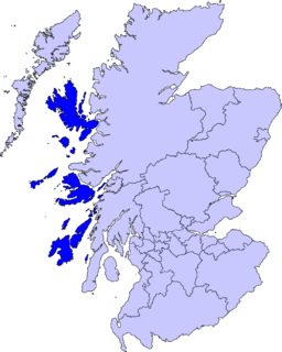
The Inner Hebrides is an archipelago off the west coast of mainland Scotland, to the south east of the Outer Hebrides. Together these two island chains form the Hebrides, which experience a mild oceanic climate. The Inner Hebrides comprise 35 inhabited islands as well as 44 uninhabited islands with an area greater than 30 hectares. Skye, Mull, and Islay are the three largest, and also have the highest populations. The main commercial activities are tourism, crofting, fishing and whisky distilling. In modern times the Inner Hebrides have formed part of two separate local government jurisdictions, one to the north and the other to the south. Together, the islands have an area of about 4,130 km2 (1,594 sq mi), and had a population of 18,948 in 2011. The population density is therefore about 4.6 inhabitants per square kilometre.

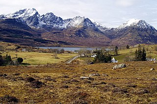
The Cuillin is a range of rocky mountains located on the Isle of Skye in Scotland. The main Cuillin ridge is also known as the Black Cuillin to distinguish it from the Red Cuillin, which lie to the east of Glen Sligachan.

Knoydart is a peninsula in Lochaber, Highland, on the west coast of Scotland. Knoydart is sandwiched between Lochs Nevis and Hourn — often translated as "Loch Heaven" and "Loch Hell" respectively, although the somewhat poetic nature of these derivations is disputed. Forming the northern part of what is traditionally known as na Garbh-Chrìochan or "the Rough Bounds", because of its harsh terrain and remoteness, Knoydart is also referred to as "Britain's last wilderness". It is only accessible by boat, or by a 16-mile (26 km) walk through rough country, and the seven miles (11 km) of tarred road are not connected to the UK road system.

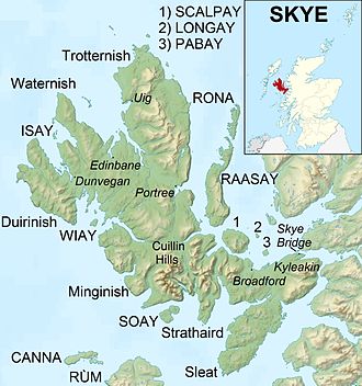
Sleat is a peninsula on the island of Skye in the Highland council area of Scotland, known as "the garden of Skye". It is the home of the clan MacDonald of Sleat. The name comes from the Scottish Gaelic Slèite, which in turn comes from Old Norse sléttr, which well describes Sleat when considered in the surrounding context of the mainland, Skye and Rùm mountains that dominate the horizon all about Sleat.

Blà Bheinn, is a mountain on the Isle of Skye in Scotland. It is usually regarded as an outlier to the Black Cuillin. It is mainly composed of gabbro, a rock with excellent grip for mountaineers and scramblers. The name Blà Bheinn is thought to mean "blue mountain", from a combination of Norse and Gaelic. Whereas blå in Modern Norwegian means "blue", the Old Norse word blá could, however, also refer to the colours blue-black and black.

Trotternish or Tròndairnis is the northernmost peninsula of the Isle of Skye, in Scotland. Its most northerly point, Rubha Hùinis, is the most northerly point of Skye.

Clan Donald, also known as Clan MacDonald, is a Highland Scottish clan and one of the largest Scottish clans. The Lord Lyon King of Arms, who is the Scottish official with responsibility for regulating heraldry in that country, issuing new grants of coats of arms, and serving as the judge of the Court of the Lord Lyon, recognizes under Scottish law the High Chief of Clan Donald. Historically the chiefs of the Clan Donald held the title of Lord of the Isles until 1493 and two of those chiefs also held the title of Earl of Ross until 1476.

The John Muir Trust (JMT) is a Scottish charity, established in 1983 to conserve wild land and wild places for the benefit of all. The Trust runs an environmental award scheme, manages several estates, mainly in the Highlands and Islands of Scotland and campaigns for better protection of wild land. In 2017, it took on a lease to manage Glenridding Common in the English Lake District.
A dun is an ancient or medieval fort.
Torrin is a settlement on the island of Skye in Scotland.

Camasunary is a bay on the Strathaird peninsula of the Isle of Skye, Scotland. Camasunary is the Scots form of the Gaelic name Camas Fhionnairigh, and means "Bay of the White Shieling". The township has about 10 ruined houses.

Dun Ringill is an Iron Age hill fort on the Strathaird peninsula on the island of Skye, Scotland. Further fortified in the Middle Ages, tradition holds that it was for several centuries the seat of Clan MacKinnon. It is located east of Kirkibost on the west shore of Loch Slapin.

Kilmarie or Kilmaree, is a village in the Isle of Skye, Scotland. Its most notable feature is the village church and graveyard. The graveyard has a significant number of tombstones from highland clans, in particular Clan MacKinnon. Nearby is Kilmarie House, former residence of Jethro Tull member Ian Anderson.
Elgol is a village on the shores of Loch Scavaig towards the end of the Strathaird peninsula in the Isle of Skye, in the Scottish Highlands.

Glen Shiel is a glen in the Northwest Highlands of Scotland.

The Isle of Skye, or simply Skye, is the largest and northernmost of the major islands in the Inner Hebrides of Scotland. The island's peninsulas radiate from a mountainous hub dominated by the Cuillin, the rocky slopes of which provide some of the most dramatic mountain scenery in the country. Although Sgitheanach has been suggested to describe a winged shape, no definitive agreement exists as to the name's origins.

Minginish is a peninsula on the Isle of Skye in Scotland. It is situated on the west coast of the island and runs from Loch Scavaig in the south, along the western coast of Skye to Loch Bracadale in the north west, to Loch Harport in the north east, and Glen Sligachan in the south east. It includes most of the peaks of the Cuillin hills including Sgurr Alasdair, the highest point on the island at 992 metres (3,255 ft). The island of Soay lies offshore across the Soay Sound, with the Small Isles further south across the Cuillin Sound.
Duirinish is a peninsula on the island of Skye in Scotland. It is situated in the north west between Loch Dunvegan and Loch Bracadale.

Rubha an Dùnain or Rubh' an Dùnain is an uninhabited peninsula to the south of the Cuillin hills on the Isle of Skye in Scotland. It contains unique archaeological sites which in 2017 were designated as a Historic Monument of national importance by Historic Environment Scotland.

Lochalsh is a district of mainland Scotland that is currently part of the Highland council area. It is a hilly peninsula that lies between Loch Carron and Loch Alsh. The main settlement is Kyle of Lochalsh, located at the entrance to Loch Alsh, opposite the village of Kyleakin on the adjacent island of Skye. A ferry used to connect the two settlements but was replaced by the Skye Bridge in 1995.