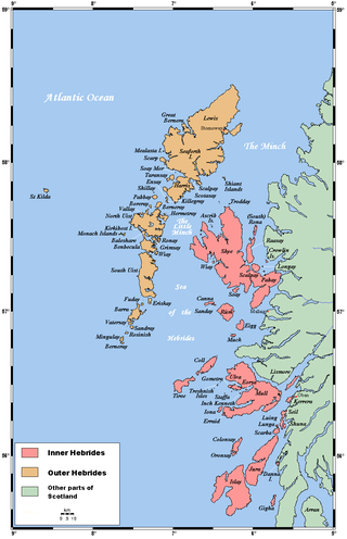
The Hebrides are an archipelago off the west coast of the Scottish mainland. The islands fall into two main groups, based on their proximity to the mainland: the Inner and Outer Hebrides.

The Inner Hebrides is an archipelago off the west coast of mainland Scotland, to the south east of the Outer Hebrides. Together these two island chains form the Hebrides, which experience a mild oceanic climate. The Inner Hebrides comprise 35 inhabited islands as well as 44 uninhabited islands with an area greater than 30 hectares. Skye, Mull, and Islay are the three largest, and also have the highest populations. The main commercial activities are tourism, crofting, fishing and whisky distilling. In modern times the Inner Hebrides have formed part of two separate local government jurisdictions, one to the north and the other to the south. Together, the islands have an area of about 4,130 km2 (1,594 sq mi), and had a population of 18,948 in 2011. The population density is therefore about 4.6 inhabitants per square kilometre.
Raasay or the Isle of Raasay is an island between the Isle of Skye and the mainland of Scotland. It is separated from Skye by the Sound of Raasay and from Applecross by the Inner Sound. It is famous for being the birthplace of Gaelic poet Sorley MacLean, an important figure in the Scottish Renaissance.

Rona, sometimes called South Rona to distinguish it from North Rona, is an inhabited island in the Inner Hebrides. It lies between the Sound of Raasay and the Inner Sound just north of the neighbouring island of Raasay and east of the Trotternish peninsula of Skye. It has a total area of 930 hectares (3.6 sq mi) and a population of 3.

Clan MacLeod is a Highland Scottish clan associated with the Isle of Skye. There are two main branches of the clan: the MacLeods of Harris and Dunvegan, whose chief is MacLeod of MacLeod, are known in Gaelic as Sìol Tormoid ; the Clan MacLeod of Lewis and Raasay, whose chief is MacLeod of The Lewes, are known in Gaelic as Sìol Torcaill. Both branches claim descent from Leòd, who lived in the 13th century.

Isay is an uninhabited island in the Inner Hebrides of the west coast of Scotland. It lies in Loch Dunvegan, 1 kilometre (1,100 yd) off the northwest coast of the Isle of Skye. Two smaller isles of Mingay and Clett lie nearby. The name originated from the Old Norse ise-øy meaning porpoise island. The island of Lampay is due south. The area of Isay is 60 hectares.
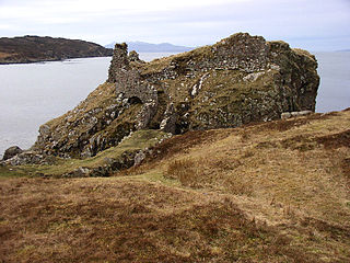
Dunscaith Castle also known as Dun Scaich, Dun Sgathaich Castle and Tokavaig, is a ruined castle on the coast of the Isle of Skye, in the north-west of Scotland. It is located in the Parish of Sleat, in the Highland council area, and in the former county of Inverness-shire, at grid reference NG595120. Also called "Fortress of Shadows", it is the legendary home of the warrior maiden Scáthach, after whom it is named. It is protected as a scheduled monument.
Malcolm Slesser was a Scottish energy analyst, scientist and mountaineer.

Clach Glas is a mountain on the Black Cuillin of the Isle of Skye, Scotland. Its elevation is 786 m (2,579 ft) and the name translates as The Grey Stone. It is often traversed as a sustained scrambling route to Blà Bheinn, mostly at a standard between Easy and Moderate, depending on the line followed. It is the penultimate mountain in the Greater Traverse of the Black Cuillin.
Na Fir Bhrèige is a set of three standing stones on the Isle of North Uist in the Outer Hebrides. They lie on the northwestern slope of Blashaval.

Waternish or Vaternish is a peninsula approximately 12 kilometres long on the island of Skye, Scotland, situated between Loch Dunvegan and Loch Snizort in the northwest of the island, and originally inhabited and owned by Clan MacNeacail/MacNicol/Nicolsons.

The Battle of the Spoiling Dyke (also known as the Battle of the Spoiled Dyke, was a Scottish clan battle that took place in 1578, fought in the Scottish Highlands, between the MacDonalds of Uist and the Clan MacLeod.
Stein is a crofting township, situated on the north eastern shore of Loch Bay, in the west of the Waternish peninsula, on the isle of Skye in the Highlands of Scotland. Previously known as Lochbay, it is in the council area of Highland.

The Isle of Skye, or simply Skye, is the largest and northernmost of the major islands in the Inner Hebrides of Scotland. The island's peninsulas radiate from a mountainous hub dominated by the Cuillin, the rocky slopes of which provide some of the most dramatic mountain scenery in the country. Although Sgitheanach has been suggested to describe a winged shape, no definitive agreement exists as to the name's origins.

The Battle of Carinish was a Scottish clan battle fought in North Uist in 1601. It was part of a year of feuding between Clan MacLeod of Dunvegan and the Clan MacDonald of Sleat, that ended with a MacDonald victory and an enforced peace.
Minginish is a peninsula on the Isle of Skye in Scotland. It is situated on the west coast of the island and runs from Loch Scavaig in the south, along the western coast of Skye to Loch Bracadale in the north west, to Loch Harport in the north east, and Glen Sligachan in the south east. It includes most of the peaks of the Cuillin hills including Sgurr Alasdair, the highest point on the island at 992 metres (3,255 ft). The island of Soay lies offshore across the Soay Sound, with the Small Isles further south across the Cuillin Sound.
Duirinish is a peninsula and civil parish on the island of Skye in Scotland. It is situated in the north west between Loch Dunvegan and Loch Bracadale.
Eilean Fladday is a previously populated tidal island off Raasay, near the Isle of Skye, Scotland.

Staffin Island is an uninhabited islet off the east coast of the Trotternish peninsula of Skye in Scotland.

Healabhal Mhòr, is a hill in the north of the Isle of Skye, Scotland. It is also known as MacLeod's Table North, as it lies close the fellow flat-topped hill of Healabhal Bheag, or MacLeod's Table South. Despite its lower height, it has a greater bulk than its neighbour.
