
Shetland, also called the Shetland Islands, is an archipelago in Scotland lying between Orkney, the Faroe Islands, and Norway. It is the northernmost region of the United Kingdom. Until 1975, it was known as Zetland.

Lerwick is the main town and port of the Shetland archipelago, Scotland. Shetland's only burgh, Lerwick had a population of about 7,000 residents in 2010. It is the northernmost major settlement within the United Kingdom.

Yell is one of the North Isles of Shetland, Scotland. In the 2011 census it had a usually resident population of 966. It is the second largest island in Shetland after the Mainland with an area of 82 square miles (212 km2), and is the third most populous in the archipelago, after the Mainland and Whalsay.

Fetlar is one of the North Isles of Shetland, Scotland, with a usually resident population of 61 at the time of the 2011 census. Its main settlement is Houbie on the south coast, home to the Fetlar Interpretive Centre. Other settlements include Aith, Funzie, Herra and Tresta. Fetlar is the fourth-largest island of Shetland and has an area of just over 4,000 ha.

Unst is one of the North Isles of the Shetland Islands, Scotland. It is the northernmost of the inhabited British Isles and is the third-largest island in Shetland after Mainland and Yell. It has an area of 46 sq mi (120 km2).

The North Isles are the northern islands of the Shetland Islands, Scotland. The main islands in the group are Yell, Unst and Fetlar. Sometimes the islands in Yell Sound are included in this group.
Uyea is an uninhabited island, lying south of Unst in Shetland, Scotland.

Out Stack is an island in Shetland, and the northernmost point of Scotland, the United Kingdom, and the British Isles.
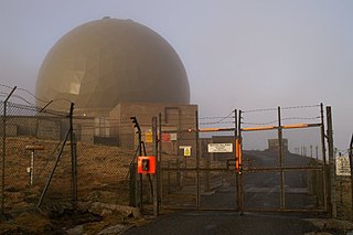
Remote Radar Head Saxa Vord or RRH Saxa Vord, is a Royal Air Force radar station located on the island of Unst, the most northern of the Shetland Islands in Scotland. As of July 2019 it is once more a fully operational radar station, after closure in 2006. The station's motto Praemoneo de Periculis reflects its role. RAF Saxa Vord is further north than Saint Petersburg in Russia, and on the same latitude as Anchorage, Alaska. The station was named after Saxa Vord, which is the highest hill on Unst at 935 ft (285 m). It holds the unofficial British record for wind speed, which in 1992 was recorded at 197 mph (317 km/h) — just before the measuring equipment blew away.

Muckle Flugga is a small rocky island north of Unst in the Shetland Islands, Scotland. It is often described as the northernmost point of the British Isles, but the smaller islet of Out Stack is actually further north. It used to be the northernmost inhabited island, but forfeited that accolade to Unst when Muckle Flugga Lighthouse was automated in 1995 and the last residents moved out.
Huney is an uninhabited island due east of the island of Unst in the Shetland Islands, Scotland. The island is located approximately 1 kilometre south west of Balta and has an area of just under 0.2 square kilometres (0.08 sq mi). Huney is separated from Unst by a narrow channel called The Yei. At extremely low tides a sandy tombolo may connect Huney to Unst.

Haroldswick or Harold's Wick, is on Unst, Shetland Islands, Scotland, and is one of the most northerly settlements in the British Isles.
Laurence Bruce of Cultmalindie was a Scottish landowner and factor to the Earl of Orkney. He features in a number of traditional stories of Shetland.

Baltasound is the largest settlement on the island of Unst in Shetland, Scotland. It comes from the Old Norse man's name Balti (Baltisund). Unst is the most northerly inhabited island in the United Kingdom. The village lies halfway along the island's east coast on a sheltered bay called Balta Sound.

The Valhalla Brewery in Unst, Shetland, Scotland, was the northernmost brewery in the United Kingdom. It was opened by the husband and wife team Sonny and Silvia Priest in December 1997, and originally based in a large shed in Baltasound, in the centre of Unst. In 2012 the brewery moved to a building at the former RAF Saxa Vord radar station, near Haroldswick. This larger premises allowed the brewery to double production to 144,000 litres a year.

The A968 in Shetland is the United Kingdom's northernmost A-road. It connects the islands of Yell and Unst to the island of Mainland. The road is actually separated into three. The length of the part of the road on Mainland is 9.8 miles (15.8 km), on Yell 17.4 miles (28.0 km), and on Unst 10 miles (16 km). The road is marked red on most maps and goes from the A970 on Mainland to Haroldswick. It is 41.9 miles (67.4 km) long.

Bluemull Sound is the strait between Unst and Yell in Shetland's North Isles. A ferry service crosses it regularly. Cullivoe is on the Yell side, and the island of Linga lies in the strait.
The Society of Our Lady of the Isles (SOLI) is a small Anglican religious order for women, founded in the late 20th century. It is located in Shetland, and is part of the Scottish Episcopal Church. It is arguably the most remote community within the Anglican Communion. The Rule of the community is a mixture of Franciscan and Cistercian, but with heavy Celtic influences.
Screenplay is an international film festival held annually in Shetland, Scotland. The festival is curated by the film critic Mark Kermode and the film historian Linda Ruth Williams in partnership with Shetland Arts. Since 2012 the festival has been hosted by Mareel arts venue in Lerwick.
SaxaVord Spaceport, previously known as Shetland Space Centre, is a UK spaceport located on the Lamba Ness peninsula on Unst, the most northerly of the inhabited Shetland Islands off the coast of Scotland. The site is near the RAF Saxa Vord radar station and the settlement of Skaw.

